TopoQuest Logo
Do you find TopoQuest useful?
Help keep TopoQuest running and adding new maps/features by donating!
Bitcoin:  19c7KJd3qBynnjoSw5npx9KScwjBe4ifkT
Litecoin:  LXs6TkuXGGXo1vDsWCkWVdjQX94eUKd6ui
Home View Maps Find Maps Find Places Resources & Links


Scotland, Connecticut Topographic Map

USGS Map Title: Scotland, CT
USGS Map MRC: 41072F1
DRG (GeoTIFF) Download: o41072f1.tif


Neighboring USGS Topographic Map Quads:


  Spring Hill, CT  
41072G2
 

  Hampton, CT  
41072G1
 

  Danielson, CT  
41071G8
 

  Willimantic, CT  
41072F2
 

  Scotland, CT  
41072F1
 

  Plainfield, CT  
41071F8
 

  Fitchville, CT  
41072E2
 

  Norwich, CT  
41072E1
 

  Jewett City, CT  
41071E8


Map MRC Location:

N42°
W73°
N42°
W72°
H8 H7 H6 H5 H4 H3 H2 H1
G8 G7 G6 G5 G4 G3 G2 G1
F8 F7 F6 F5 F4 F3 F2 F1
E8 E7 E6 E5 E4 E3 E2 E1
D8 D7 D6 D5 D4 D3 D2 D1
C8 C7 C6 C5 C4 C3 C2 C1
B8 B7 B6 B5 B4 B3 B2 B1
A8 A7 A6 A5 A4 A3 A2 A1
N41°
W73°
N41°
W72°

Scotland, CT USGS 1:24K Topographic Map Preview:
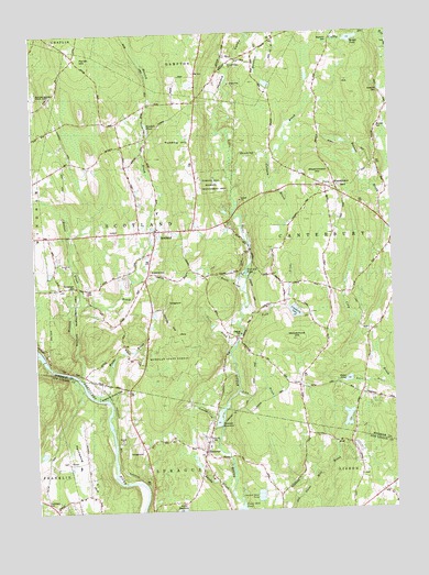
Scotland, CT USGS Topographic Map
Click on map above to begin viewing in our Map Viewer.

This topographic map contains these locations and features:
Feature Name Type Latitude Longitude GNIS ID View Map
Adams BrookStreamN41.6295°W72.0581°205041View Map
Bates BrookStreamN41.6587°W72.0017°205306View Map
Bates PondLakeN41.6589°W72.0157°205309View Map
Beaver BrookStreamN41.6795°W72.1087°205370View Map
Bennett CemeteryCemeteryN41.7248°W72.0039°205446View Map
Bradford CemeteryCemeteryN41.7341°W72.0033°205666View Map
Burnham BrookStreamN41.7473°W72.0473°205850View Map
Christian Fellowship ChurchChurchN41.7101°W72.0673°1924320View Map
Church BridgeBridgeN41.6868°W72.0856°1924322View Map
Clover BrookStreamN41.7193°W72.0867°1924331View Map
Coffey BrookStreamN41.7484°W72.0020°206353View Map
Colburn BrookStreamN41.7176°W72.0415°206359View Map
Deane BrookStreamN41.6787°W72.0359°206637View Map
Downing BrookStreamN41.7123°W72.0548°206732View Map
Edward Waldo House MuseumBuildingN41.6590°W72.1006°1924383View Map
Fall River Rod and Gun ClubLocaleN41.6657°W72.1184°599707View Map
Fort Ned PondLakeN41.6871°W72.0511°207152View Map
HanoverPopulated PlaceN41.6426°W72.0654°207663View Map
Hanover Congregational ChurchChurchN41.6407°W72.0662°1930991View Map
Hanover Post OfficePost OfficeN41.6418°W72.0660°1930992View Map
Hanover ReservoirReservoirN41.6495°W72.0610°207665View Map
Hanover Reservoir DamDamN41.6473°W72.0606°1771098View Map
Hickory Grove Roadside ParkParkN41.6990°W72.1101°1924454View Map
Highland CampgroundLocaleN41.6798°W72.0781°1924455View Map
Howard Valley ChurchChurchN41.7420°W72.0542°207984View Map
John BrookStreamN41.6565°W72.0537°208167View Map
Kimball PondReservoirN41.7255°W72.0845°208296View Map
Lisbon PondReservoirN41.6491°W72.0162°1771588View Map
Lisbon Pond DamDamN41.6468°W72.0179°1771587View Map
Merrick BrookStreamN41.6612°W72.1101°208837View Map
Monty BrookStreamN41.6826°W72.0517°209009View Map
Nature ConservatoryBuildingN41.7218°W72.0687°1924564View Map
New Scotland CemeteryCemeteryN41.6861°W72.0851°1924570View Map
Old Scotland CemeteryCemeteryN41.6877°W72.0844°210706View Map
Palmertown CemeteryCemeteryN41.6846°W72.1106°209602View Map
Parish HillSummitN41.7443°W72.1092°209635View Map
Park CemeteryCemeteryN41.7101°W72.0241°1924614View Map
Parker PondReservoirN41.6875°W72.1194°1924615View Map
Pautipaug CemeteryCemeteryN41.6273°W72.1218°209652View Map
Pautipaug Golf Course and Country ClubLocaleN41.6379°W72.1137°1931376View Map
Pautipaug HillSummitN41.6320°W72.1051°209653View Map
Peck BrookStreamN41.6782°W72.0495°209673View Map
Pudding HillSummitN41.7207°W72.0717°210008View Map
Raymond CemeteryCemeteryN41.7478°W72.0201°210124View Map
Saint Margarets ChurchChurchN41.6987°W72.0820°1924708View Map
ScotlandPopulated PlaceN41.6984°W72.0815°210705View Map
Scotland Congregational ChurchChurchN41.6993°W72.0817°1924720View Map
Scotland DamDamN41.6651°W72.1220°1770564View Map
Scotland Elementary SchoolSchoolN41.7034°W72.0815°1924721View Map
Scotland Post OfficePost OfficeN41.6987°W72.0807°1924722View Map
Scotland Public LibraryBuildingN41.6982°W72.0826°1924723View Map
Scotland Volunteer Fire Department Station 16BuildingN41.7014°W72.0831°1924725View Map
Smith BrookStreamN41.6670°W72.0556°210912View Map
Town of ScotlandCivilN41.6978°W72.0880°213501View Map
Town of SpragueCivilN41.6305°W72.0758°213510View Map
Waldo BrookStreamN41.6551°W72.0998°211767View Map
WestminsterPopulated PlaceN41.7095°W72.0181°212021View Map
Westminster CemeteryCemeteryN41.7098°W72.0200°1924822View Map
Westminster Congregational ChurchChurchN41.7093°W72.0198°1924821View Map
Westminster HillSummitN41.7112°W72.0229°212022View Map
Woodchuck HillSummitN41.6701°W72.0337°212241View Map
Wright PondLakeN41.7481°W72.0126°212288View Map

Note: Coordinates in the location and feature list above are referenced to NAD83 datum.


Copyright (C) 2008-2025 Ryan Niemi / Sunset Dynamics ... All Rights Reserved