TopoQuest Logo
Do you find TopoQuest useful?
Help keep TopoQuest running and adding new maps/features by donating!
Bitcoin:  19c7KJd3qBynnjoSw5npx9KScwjBe4ifkT
Litecoin:  LXs6TkuXGGXo1vDsWCkWVdjQX94eUKd6ui
Home View Maps Find Maps Find Places Resources & Links


Scotts Hill, Tennessee Topographic Map

USGS Map Title: Scotts Hill, TN
USGS Map MRC: 35088E2
DRG (GeoTIFF) Download: o35088e2.tif


Neighboring USGS Topographic Map Quads:


  Chesterfield, TN  
35088F3
 

  Parsons, TN  
35088F2
 

  Jeannette, TN  
35088F1
 

  Reagan, TN  
35088E3
 

  Scotts Hill, TN  
35088E2
 

  Perryville, TN  
35088E1
 

  Sardis, TN  
35088D3
 

  Thurman, TN  
35088D2
 

  Bath Springs, TN  
35088D1


Map MRC Location:

N36°
W89°
N36°
W88°
H8 H7 H6 H5 H4 H3 H2 H1
G8 G7 G6 G5 G4 G3 G2 G1
F8 F7 F6 F5 F4 F3 F2 F1
E8 E7 E6 E5 E4 E3 E2 E1
D8 D7 D6 D5 D4 D3 D2 D1
C8 C7 C6 C5 C4 C3 C2 C1
B8 B7 B6 B5 B4 B3 B2 B1
A8 A7 A6 A5 A4 A3 A2 A1
N35°
W89°
N35°
W88°

Scotts Hill, TN USGS 1:24K Topographic Map Preview:
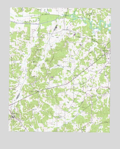
Scotts Hill, TN USGS Topographic Map
Click on map above to begin viewing in our Map Viewer.

This topographic map contains these locations and features:
Feature Name Type Latitude Longitude GNIS ID View Map
Arms CreekStreamN35.6176°W88.1714°1275860View Map
Averett CemeteryCemeteryN35.5248°W88.1595°1304902View Map
Bear CreekStreamN35.6109°W88.1506°1276589View Map
Beech River SloughStreamN35.6103°W88.2120°1276856View Map
Betsy BranchStreamN35.5656°W88.1675°1277183View Map
Big CreekStreamN35.6181°W88.1820°1277280View Map
Blue CreekStreamN35.5423°W88.2361°1277751View Map
Brasher CemeteryCemeteryN35.5145°W88.1884°1278244View Map
Buckner HollowValleyN35.6212°W88.2341°1278885View Map
Bumpers BluffCliffN35.6159°W88.1603°1278983View Map
Camp Ground ChurchChurchN35.5956°W88.1625°1305628View Map
Cane CreekStreamN35.6190°W88.2489°1305662View Map
Chumney CemeteryCemeteryN35.5426°W88.2461°1280544View Map
Commissioner District 3CivilN35.5908°W88.1385°2464137View Map
Concord ChurchChurchN35.5387°W88.1361°1306063View Map
Crawford ChurchChurchN35.5151°W88.1886°1281581View Map
Crawford School (historical)SchoolN35.5154°W88.1898°1316731View Map
Crowell Chapel Methodist Church (historical)ChurchN35.5948°W88.2325°1317465View Map
Crowell SchoolSchoolN35.5945°W88.2311°1281755View Map
Darden BranchStreamN35.6184°W88.2014°1282039View Map
Davis CemeteryCemeteryN35.5376°W88.1800°1282141View Map
Davis SchoolSchoolN35.5440°W88.1706°1282205View Map
Decatur County Training School (historical)SchoolN35.5801°W88.1281°1316735View Map
Decaturville Division (historical)CensusN35.5276°W88.1450°1648669View Map
Decaturville Elementary SchoolSchoolN35.5745°W88.1275°1316736View Map
Dixie MillsPopulated PlaceN35.6148°W88.1828°1314950View Map
Dunivant SchoolSchoolN35.5592°W88.2039°1307266View Map
Festus Jackson DamDamN35.5543°W88.1960°1301918View Map
Festus Jackson LakeReservoirN35.5550°W88.1970°1301917View Map
Flat CreekStreamN35.6181°W88.2106°1284379View Map
GarrettPopulated PlaceN35.6020°W88.1761°1315098View Map
Garrett School (historical)SchoolN35.5901°W88.1784°1316742View Map
Graves ChapelChurchN35.5023°W88.1603°1316744View Map
Graves Chapel SchoolSchoolN35.5023°W88.1600°1285959View Map
Harrington CemeteryCemeteryN35.5706°W88.1792°1286938View Map
Hensley CemeteryCemeteryN35.5862°W88.2161°1287458View Map
Herndon CemeteryCemeteryN35.6184°W88.1253°1287495View Map
Houston CemeteryCemeteryN35.5851°W88.1311°1288507View Map
Johnson CreekStreamN35.6142°W88.1561°1289600View Map
Lacy BranchStreamN35.5781°W88.2253°1290444View Map
Laster BranchStreamN35.5437°W88.1409°1290664View Map
Lewis Lacy Dam Number TwoDamN35.5984°W88.1700°1301950View Map
Lewis Lacy Lake Number TwoReservoirN35.5980°W88.1700°1301951View Map
Millpond BranchStreamN35.5326°W88.2400°1293987View Map
Mills BranchStreamN35.6195°W88.2025°1293989View Map
Mount Zion Baptist ChurchChurchN35.5584°W88.2031°1294880View Map
Myracle CemeteryCemeteryN35.6231°W88.1781°1295195View Map
New Hope Baptist ChurchChurchN35.5987°W88.1773°1295533View Map
Newson CemeteryCemeteryN35.5948°W88.2106°1295703View Map
Old Ponta PondLakeN35.6212°W88.2183°1296350View Map
Panther CreekStreamN35.6145°W88.1684°1296733View Map
Peace ChapelChurchN35.5220°W88.2206°1297041View Map
Pearcy BranchStreamN35.5876°W88.1439°1297070View Map
Pentecost ChurchChurchN35.5062°W88.2331°1316770View Map
Polly BranchStreamN35.5717°W88.1664°1298076View Map
Powers BranchStreamN35.5956°W88.1873°1298435View Map
Powers BranchStreamN35.5692°W88.2309°1298436View Map
Pratt CemeteryCemeteryN35.5403°W88.2231°1298464View Map
Presley CemeteryCemeteryN35.5928°W88.2261°1298474View Map
Pudding BranchStreamN35.5256°W88.1623°1298652View Map
Robins Store (historical)LocaleN35.5951°W88.2114°1317516View Map
Rosson CemeteryCemeteryN35.6242°W88.1381°1300136View Map
Rushing CemeteryCemeteryN35.5673°W88.1909°1316773View Map
Rushing Creek ChurchChurchN35.5595°W88.1367°1300287View Map
Rushing Grove ChurchChurchN35.5670°W88.1911°1300290View Map
Scotts HillPopulated PlaceN35.5151°W88.2453°1300964View Map
Scotts Hill First Baptist ChurchChurchN35.5184°W88.2464°1317528View Map
Scotts Hill SchoolSchoolN35.5134°W88.2442°1317529View Map
Scotts Hill Volunteer Fire DepartmentBuildingN35.5145°W88.2455°2654280View Map
Skull BranchStreamN35.6078°W88.1261°1310590View Map
Smith ChapelChurchN35.5723°W88.2211°1303672View Map
Smith School (historical)SchoolN35.5606°W88.1325°1316775View Map
Thompson BranchStreamN35.5462°W88.1492°1272504View Map
Trinity Tabernacle Assembly of God ChurchChurchN35.5695°W88.1275°1644678View Map
Turkey CreekStreamN35.6040°W88.1473°1273000View Map
Whites SpringSpringN35.5967°W88.1468°1274464View Map
Yarbro CemeteryCemeteryN35.5809°W88.1486°1275234View Map

Note: Coordinates in the location and feature list above are referenced to NAD83 datum.


Copyright (C) 2008-2025 Ryan Niemi / Sunset Dynamics ... All Rights Reserved