TopoQuest Logo
Do you find TopoQuest useful?
Help keep TopoQuest running and adding new maps/features by donating!
Bitcoin:  19c7KJd3qBynnjoSw5npx9KScwjBe4ifkT
Litecoin:  LXs6TkuXGGXo1vDsWCkWVdjQX94eUKd6ui
Home View Maps Find Maps Find Places Resources & Links


Sugar Tree, Tennessee Topographic Map

USGS Map Title: Sugar Tree, TN
USGS Map MRC: 35088G1
DRG (GeoTIFF) Download: o35088g1.tif


Neighboring USGS Topographic Map Quads:


  Seventeen Creek, TN  
35088H2
 

  Rockport, TN  
35088H1
 

  Hustburg, TN  
35087H8
 

  Holladay, TN  
35088G2
 

  Sugar Tree, TN  
35088G1
 

  Daniels Landing, TN  
35087G8
 

  Parsons, TN  
35088F2
 

  Jeannette, TN  
35088F1
 

  Pine View, TN  
35087F8


Map MRC Location:

N36°
W89°
N36°
W88°
H8 H7 H6 H5 H4 H3 H2 H1
G8 G7 G6 G5 G4 G3 G2 G1
F8 F7 F6 F5 F4 F3 F2 F1
E8 E7 E6 E5 E4 E3 E2 E1
D8 D7 D6 D5 D4 D3 D2 D1
C8 C7 C6 C5 C4 C3 C2 C1
B8 B7 B6 B5 B4 B3 B2 B1
A8 A7 A6 A5 A4 A3 A2 A1
N35°
W89°
N35°
W88°

Sugar Tree, TN USGS 1:24K Topographic Map Preview:
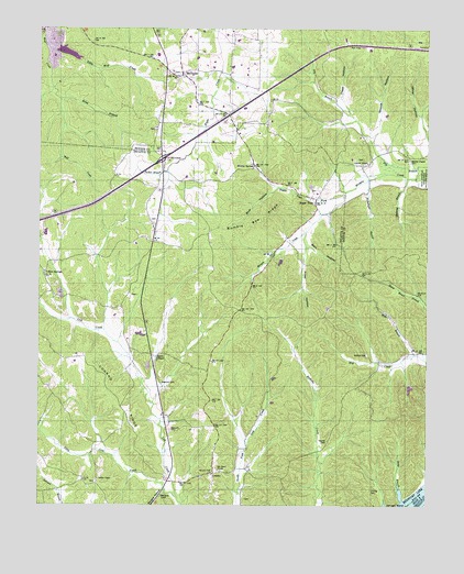
Sugar Tree, TN USGS Topographic Map
Click on map above to begin viewing in our Map Viewer.

This topographic map contains these locations and features:
Feature Name Type Latitude Longitude GNIS ID View Map
Akins ChapelChurchN35.7903°W88.0900°1275520View Map
Akins ChapelPopulated PlaceN35.7890°W88.0867°1310568View Map
Atkins Chapel School (historical)SchoolN35.7856°W88.0881°1316714View Map
Baker CemeteryCemeteryN35.7537°W88.0370°1647365View Map
Barn HollowValleyN35.8192°W88.0389°1276329View Map
Baugus HollowValleyN35.7534°W88.0860°1276500View Map
Bawcum CemeteryCemeteryN35.7695°W88.0828°1276502View Map
Bawcum CemeteryCemeteryN35.7823°W88.0861°1276503View Map
Becks BranchStreamN35.7515°W88.0078°1305045View Map
Bliss (historical)Populated PlaceN35.7912°W88.0956°1310571View Map
Blue HollowValleyN35.8333°W88.0486°1277767View Map
Bumble Bee RidgeRidgeN35.8240°W88.0564°1278980View Map
Cantrell ChapelChurchN35.8401°W88.0195°1305677View Map
Cheney CemeteryCemeteryN35.7539°W88.0178°1280317View Map
Conrad RidgeRidgeN35.7801°W88.1003°1281098View Map
CozettePopulated PlaceN35.7584°W88.0686°1306161View Map
Diggs HollowValleyN35.8563°W88.0282°1282468View Map
Dry BranchStreamN35.8370°W88.0006°1282884View Map
Etna (historical)Populated PlaceN35.7592°W88.0811°1310576View Map
Flatwood SchoolSchoolN35.8484°W88.0875°1284453View Map
Flatwoods Baptist ChurchChurchN35.8492°W88.0873°1644703View Map
Flawoods CemeteryCemeteryN35.8487°W88.0875°1644704View Map
Hartley CemeteryCemeteryN35.7898°W88.0195°1287053View Map
Haynes CemeteryCemeteryN35.7670°W88.0323°1287227View Map
Holladay - McIllwain Volunteer Fire DepartmentBuildingN35.8631°W88.0821°2653918View Map
Interchange 126CrossingN35.8409°W88.0856°1310582View Map
Little Lick CreekStreamN35.7520°W88.0800°1291560View Map
Little Wolf CreekStreamN35.8706°W88.1228°1291714View Map
Malins Store (historical)LocaleN35.8737°W88.0625°1316854View Map
Manley Chapel (historical)ChurchN35.8434°W88.0100°1316855View Map
Manley Chapel CemeteryCemeteryN35.8406°W88.0059°1292578View Map
Manley Chapel SchoolSchoolN35.8395°W88.0192°1292579View Map
McIllwainPopulated PlaceN35.8628°W88.0798°1293335View Map
McIllwain Methodist ChurchChurchN35.8631°W88.0786°1644713View Map
McIllwain School (historical)SchoolN35.8634°W88.0789°1316856View Map
Mills BranchStreamN35.7895°W88.0039°1293988View Map
Moore Chapel SchoolSchoolN35.8690°W88.0548°1294284View Map
Moores Chapel Methodist ChurchChurchN35.8684°W88.0542°1644714View Map
Morris SpringSpringN35.8392°W88.0564°1294438View Map
Nickeltown BranchStreamN35.8356°W88.0189°1295743View Map
Northford Post Office (historical)Post OfficeN35.7596°W88.0617°1650585View Map
Oak Grove CemeteryCemeteryN35.7592°W88.0659°1307244View Map
Oak Grove ChurchChurchN35.7592°W88.0667°1296096View Map
Oakview (historical)Populated PlaceN35.7901°W88.0028°1310585View Map
Old Morgans Creek CemeteryCemeteryN35.8409°W88.0206°1644723View Map
Poley HollowValleyN35.8173°W88.0388°1298051View Map
Riley BranchStreamN35.8567°W88.1184°1299448View Map
Rocky Springs SchoolSchoolN35.7748°W88.1159°1299938View Map
Shakerag BranchStreamN35.8362°W88.0067°1301204View Map
Spence Cumberland Presbyterian Church (historical)ChurchN35.8256°W88.0900°1644676View Map
Spence SchoolSchoolN35.8251°W88.0903°1270984View Map
Spences StoreLocaleN35.8312°W88.0889°1303750View Map
Sugar TreePopulated PlaceN35.8292°W88.0361°1303902View Map
Sugar Tree ForkStreamN35.8317°W88.0273°1303903View Map
Sugar Tree Post OfficePost OfficeN35.8288°W88.0364°1650592View Map
Sugar Tree School (historical)SchoolN35.8326°W88.0348°1316777View Map
Suttles ChapelChurchN35.7567°W88.1056°1303951View Map
Suttles School (historical)SchoolN35.7584°W88.1167°1316778View Map
Tucker BranchStreamN35.8376°W88.0848°1272940View Map
Wesson CemeteryCemeteryN35.8326°W88.0359°1644679View Map
Wesson Chapel Cumberland Presbyterian ChurchChurchN35.8273°W88.0364°1644680View Map
Woods HollowValleyN35.8476°W88.0169°1275086View Map
Yellow Spring ChurchChurchN35.8103°W88.1234°1316783View Map
Yellow SpringsPopulated PlaceN35.8109°W88.1231°1314548View Map
Yellow Springs School (historical)SchoolN35.8101°W88.1234°1316784View Map

Note: Coordinates in the location and feature list above are referenced to NAD83 datum.


Copyright (C) 2008-2024 Ryan Niemi / Sunset Dynamics ... All Rights Reserved