TopoQuest Logo
Do you find TopoQuest useful?
Help keep TopoQuest running and adding new maps/features by donating!
Bitcoin:  19c7KJd3qBynnjoSw5npx9KScwjBe4ifkT
Litecoin:  LXs6TkuXGGXo1vDsWCkWVdjQX94eUKd6ui
Home View Maps Find Maps Find Places Resources & Links


Sewee Bay, South Carolina Topographic Map

USGS Map Title: Sewee Bay, SC
USGS Map MRC: 32079H6
DRG (GeoTIFF) Download: o32079h6.tif


Neighboring USGS Topographic Map Quads:


  Huger, SC  
33079A7
 

  Ocean Bay, SC  
33079A6
 

  Awendaw, SC  
33079A5
 

  Cainhoy, SC  
32079H7
 

  Sewee Bay, SC  
32079H6
 

  Bull Island, SC  
32079H5
 

  Fort Moultrie, SC  
32079G7
 

  Capers Inlet, SC  
32079G6


Map MRC Location:

N33°
W80°
N33°
W79°
H8 H7 H6 H5 H4 H3 H2 H1
G8 G7 G6 G5 G4 G3 G2 G1
F8 F7 F6 F5 F4 F3 F2 F1
E8 E7 E6 E5 E4 E3 E2 E1
D8 D7 D6 D5 D4 D3 D2 D1
C8 C7 C6 C5 C4 C3 C2 C1
B8 B7 B6 B5 B4 B3 B2 B1
A8 A7 A6 A5 A4 A3 A2 A1
N32°
W80°
N32°
W79°

Sewee Bay, SC USGS 1:24K Topographic Map Preview:
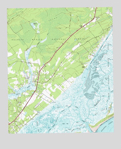
Sewee Bay, SC USGS Topographic Map
Click on map above to begin viewing in our Map Viewer.

This topographic map contains these locations and features:
Feature Name Type Latitude Longitude GNIS ID View Map
Alston CreekStreamN32.9268°W79.7359°1228011View Map
Awendaw ChurchChurchN32.9807°W79.6604°1229364View Map
Awendaw Fire District Station 1BuildingN32.9005°W79.7319°2368176View Map
Awendaw Fire District Station 2BuildingN32.9862°W79.6453°2368083View Map
Awendaw Post OfficePost OfficeN32.9819°W79.6573°2489772View Map
Awendaw SchoolSchoolN32.9896°W79.6437°1229366View Map
Awendaw Sheriff's DepartmentBuildingN32.9900°W79.6438°2489666View Map
Back CreekStreamN32.9105°W79.6295°1229368View Map
Bull NarrowsChannelN32.9041°W79.6442°1229481View Map
ChandlerPopulated PlaceN32.9046°W79.7356°1229540View Map
Charleston County Sheriff's Office SubstationBuildingN32.9899°W79.6436°2334853View Map
Clauson CreekStreamN32.9013°W79.6784°1229563View Map
Deer Creek FarmLocaleN32.9211°W79.7406°2652252View Map
Hickory BayBayN32.9285°W79.6337°1229795View Map
I'on SwampSwampN32.9819°W79.6959°1229840View Map
Mark BayBayN32.8846°W79.6823°1229971View Map
Mayrants ReserveReservoirN32.9833°W79.7198°1229980View Map
Moores LandingPopulated PlaceN32.9399°W79.6573°1230036View Map
Nebo ChurchChurchN32.9604°W79.6881°1230084View Map
Santee PassChannelN32.8774°W79.6823°1230300View Map
Santo Sotille RanchLocaleN32.9266°W79.6770°1253225View Map
Schooner CreekStreamN32.8805°W79.6581°1230310View Map
Sewee BayBayN32.9355°W79.6498°1230315View Map
Sewee ChurchChurchN32.9424°W79.7062°1230317View Map
Ten MilePopulated PlaceN32.8874°W79.7440°1230400View Map
Town of AwendawCivilN32.9826°W79.6458°2405192View Map
Twelve Mile School (historical)SchoolN32.9166°W79.7187°1253294View Map
Twenty One Mile School (historical)SchoolN32.9810°W79.6601°1253296View Map
Wappetaw Independent Congregational Church (historical)ChurchN32.9271°W79.7165°1253315View Map
Wappetow CemeteryCemeteryN32.9274°W79.7165°1230463View Map
Ward BridgeBridgeN32.9452°W79.7254°1230464View Map
WAVF-FM (Hanahan)TowerN32.9288°W79.7106°1252504View Map
WCBD-TV (Charleston)TowerN32.9402°W79.6956°1252563View Map
WCIV-TV (Charleston)TowerN32.9246°W79.6992°1252564View Map
WCSC-TV (Charleston)TowerN32.9246°W79.6992°1252565View Map
WITV-TV (Charleston)TowerN32.9246°W79.6992°1252566View Map
WoodvillePopulated PlaceN32.9313°W79.7290°1230520View Map
WSCI-FM (Charleston)TowerN32.9246°W79.6992°1252455View Map
WTAT-TV (Charleston)TowerN32.9402°W79.6956°1252568View Map
WXTC-FM (Charleston)TowerN32.9246°W79.6992°1252456View Map
Zion ChurchChurchN32.8980°W79.7337°1253348View Map

Note: Coordinates in the location and feature list above are referenced to NAD83 datum.


Copyright (C) 2008-2025 Ryan Niemi / Sunset Dynamics ... All Rights Reserved