TopoQuest Logo
Do you find TopoQuest useful?
Help keep TopoQuest running and adding new maps/features by donating!
Bitcoin:  19c7KJd3qBynnjoSw5npx9KScwjBe4ifkT
Litecoin:  LXs6TkuXGGXo1vDsWCkWVdjQX94eUKd6ui
Home View Maps Find Maps Find Places Resources & Links


Ocean Bay, South Carolina Topographic Map

USGS Map Title: Ocean Bay, SC
USGS Map MRC: 33079A6
DRG (GeoTIFF) Download: o33079a6.tif


Neighboring USGS Topographic Map Quads:


  Bethera, SC  
33079B7
 

  Shulerville, SC  
33079B6
 

  Honey Hill, SC  
33079B5
 

  Huger, SC  
33079A7
 

  Ocean Bay, SC  
33079A6
 

  Awendaw, SC  
33079A5
 

  Cainhoy, SC  
32079H7
 

  Sewee Bay, SC  
32079H6
 

  Bull Island, SC  
32079H5


Map MRC Location:

N34°
W80°
N34°
W79°
H8 H7 H6 H5 H4 H3 H2 H1
G8 G7 G6 G5 G4 G3 G2 G1
F8 F7 F6 F5 F4 F3 F2 F1
E8 E7 E6 E5 E4 E3 E2 E1
D8 D7 D6 D5 D4 D3 D2 D1
C8 C7 C6 C5 C4 C3 C2 C1
B8 B7 B6 B5 B4 B3 B2 B1
A8 A7 A6 A5 A4 A3 A2 A1
N33°
W80°
N33°
W79°

Ocean Bay, SC USGS 1:24K Topographic Map Preview:
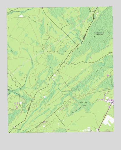
Ocean Bay, SC USGS Topographic Map
Click on map above to begin viewing in our Map Viewer.

This topographic map contains these locations and features:
Feature Name Type Latitude Longitude GNIS ID View Map
Apple Old Field CemeteryCemeteryN33.0316°W79.7290°1234414View Map
Awendaw ChurchChurchN33.0279°W79.6270°1252670View Map
Bates Still (historical)LocaleN33.1204°W79.7492°1252153View Map
Bell CreekStreamN33.0318°W79.6367°1228009View Map
Bennett BranchStreamN33.0424°W79.7465°1229399View Map
Cooter CreekStreamN33.0274°W79.6615°1229590View Map
Cropnel Dam CreekStreamN33.0657°W79.7198°1229607View Map
Fish PondLakeN33.0579°W79.6292°1230582View Map
Fort CornerPopulated PlaceN33.0791°W79.6256°1231292View Map
Halfway CreekStreamN33.0868°W79.6601°1229764View Map
Halfway CreekPopulated PlaceN33.1138°W79.6473°1234510View Map
Halfway Creek CemeteryCemeteryN33.1146°W79.6476°1234511View Map
Halfway Creek ChurchChurchN33.1141°W79.6476°1234512View Map
Halfway Creek SchoolSchoolN33.1135°W79.6476°1229765View Map
Halfway Creek Trail CampLocaleN33.0574°W79.6934°1230586View Map
Harleston Dam CreekStreamN33.0424°W79.7465°1245905View Map
Huitt BranchStreamN33.1207°W79.7329°1229835View Map
King SwampSwampN33.0175°W79.7454°1234536View Map
Lake AwendawReservoirN33.0316°W79.6259°1252671View Map
Northampton CreekStreamN33.0424°W79.7465°1230112View Map
Oakie BranchStreamN33.0916°W79.7129°1228008View Map
Oakie BranchStreamN33.1071°W79.7498°1230118View Map
Ocean BayBasinN33.0627°W79.6929°1230119View Map
Ocean Grove ChurchChurchN33.0013°W79.6431°1230120View Map
Old Man LeadStreamN33.1207°W79.7431°1230124View Map
Porcher Elementary SchoolSchoolN33.0024°W79.6454°1253139View Map
Steed CreekStreamN33.0316°W79.6359°1230364View Map
Swamp Fox TrailTrailN33.0602°W79.6887°1230563View Map
Twenty Four Mile SchoolSchoolN33.0277°W79.6273°1253295View Map
Twin Pond Rifle RangeLocaleN33.0521°W79.6401°1230583View Map
Wambaw Swamp WildernessReserveN33.1017°W79.6356°1230559View Map
Willow Hall SwampSwampN33.0307°W79.6868°1230506View Map
Withey Wood CanalStreamN33.0274°W79.6615°1230514View Map

Note: Coordinates in the location and feature list above are referenced to NAD83 datum.


Copyright (C) 2008-2024 Ryan Niemi / Sunset Dynamics ... All Rights Reserved