TopoQuest Logo
Do you find TopoQuest useful?
Help keep TopoQuest running and adding new maps/features by donating!
Bitcoin:  19c7KJd3qBynnjoSw5npx9KScwjBe4ifkT
Litecoin:  LXs6TkuXGGXo1vDsWCkWVdjQX94eUKd6ui
Home View Maps Find Maps Find Places Resources & Links


Bull Island, South Carolina Topographic Map

USGS Map Title: Bull Island, SC
USGS Map MRC: 32079H5
DRG (GeoTIFF) Download: o32079h5.tif


Neighboring USGS Topographic Map Quads:


  Ocean Bay, SC  
33079A6
 

  Awendaw, SC  
33079A5
 

  McClellanville, SC  
33079A4
 

  Sewee Bay, SC  
32079H6
 

  Bull Island, SC  
32079H5


  Capers Inlet, SC  
32079G6


Map MRC Location:

N33°
W80°
N33°
W79°
H8 H7 H6 H5 H4 H3 H2 H1
G8 G7 G6 G5 G4 G3 G2 G1
F8 F7 F6 F5 F4 F3 F2 F1
E8 E7 E6 E5 E4 E3 E2 E1
D8 D7 D6 D5 D4 D3 D2 D1
C8 C7 C6 C5 C4 C3 C2 C1
B8 B7 B6 B5 B4 B3 B2 B1
A8 A7 A6 A5 A4 A3 A2 A1
N32°
W80°
N32°
W79°

Bull Island, SC USGS 1:24K Topographic Map Preview:
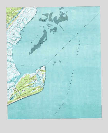
Bull Island, SC USGS Topographic Map
Click on map above to begin viewing in our Map Viewer.

This topographic map contains these locations and features:
Feature Name Type Latitude Longitude GNIS ID View Map
Anderson CreekStreamN32.9385°W79.6137°1229351View Map
Belvedere CreekStreamN32.9732°W79.6056°1229398View Map
Big PondReservoirN32.9113°W79.5963°1229424View Map
Bird Island (historical)IslandN32.9643°W79.5640°1229428View Map
Bird Island ShoalBarN32.9629°W79.5759°1229429View Map
Blind CreekStreamN32.9441°W79.6176°1229431View Map
Bull BreakersBarN32.8846°W79.5576°1229477View Map
Bull CreekStreamN32.9274°W79.6028°1229478View Map
Bull HarborBayN32.9468°W79.6009°1229479View Map
Bull IslandIslandN32.9080°W79.6090°1229480View Map
Bulls BayBayN32.9752°W79.5581°1229484View Map
Jack CreekGutN32.9227°W79.5823°1229843View Map
Lower Summerhouse PondReservoirN32.9049°W79.6086°1229959View Map
Moccasin PondLakeN32.9064°W79.5905°1230029View Map
Northeast PointCapeN32.9343°W79.5751°1230113View Map
Saltpond CreekGutN32.9907°W79.6051°1230288View Map
Sewee CampLocaleN32.9899°W79.6156°1230316View Map
Summerhouse CreekStreamN32.9221°W79.6095°1230384View Map
Turkey Walk TrailTrailN32.9083°W79.6122°1230429View Map
Upper Summerhouse PondReservoirN32.8989°W79.6183°1230438View Map
Vanderhorst CreekStreamN32.9674°W79.6056°1230441View Map
Venning CreekStreamN32.9574°W79.6131°1230444View Map
White IslandIslandN32.9910°W79.5462°1230487View Map
Wilson CemeteryCemeteryN32.9907°W79.6209°1230509View Map

Note: Coordinates in the location and feature list above are referenced to NAD83 datum.


Copyright (C) 2008-2025 Ryan Niemi / Sunset Dynamics ... All Rights Reserved