TopoQuest Logo
Do you find TopoQuest useful?
Help keep TopoQuest running and adding new maps/features by donating!
Bitcoin:  19c7KJd3qBynnjoSw5npx9KScwjBe4ifkT
Litecoin:  LXs6TkuXGGXo1vDsWCkWVdjQX94eUKd6ui
Home View Maps Find Maps Find Places Resources & Links


Marion, Kentucky Topographic Map

USGS Map Title: Marion, KY
USGS Map MRC: 37088C1
DRG (GeoTIFF) Download: o37088c1.tif


Neighboring USGS Topographic Map Quads:


  Cave-in-Rock, IL  
37088D2
 

  Repton, KY  
37088D1
 

  Blackford, KY  
37087D8
 

  Salem, KY  
37088C2
 

  Marion, KY  
37088C1
 

  Shady Grove, KY  
37087C8
 

  Dycusburg, KY  
37088B2
 

  Fredonia, KY  
37088B1
 

  Crider, KY  
37087B8


Map MRC Location:

N38°
W89°
N38°
W88°
H8 H7 H6 H5 H4 H3 H2 H1
G8 G7 G6 G5 G4 G3 G2 G1
F8 F7 F6 F5 F4 F3 F2 F1
E8 E7 E6 E5 E4 E3 E2 E1
D8 D7 D6 D5 D4 D3 D2 D1
C8 C7 C6 C5 C4 C3 C2 C1
B8 B7 B6 B5 B4 B3 B2 B1
A8 A7 A6 A5 A4 A3 A2 A1
N37°
W89°
N37°
W88°

Marion, KY USGS 1:24K Topographic Map Preview:
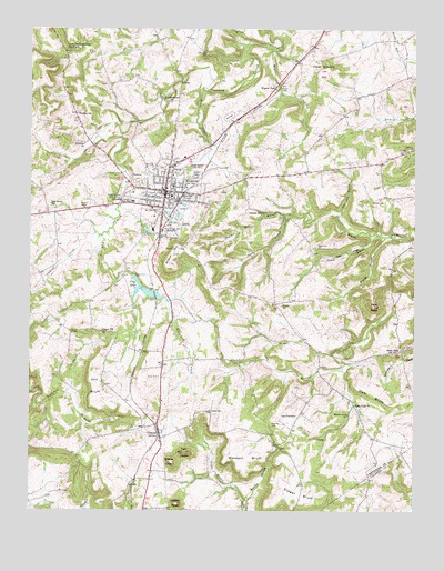
Marion, KY USGS Topographic Map
Click on map above to begin viewing in our Map Viewer.

This topographic map contains these locations and features:
Feature Name Type Latitude Longitude GNIS ID View Map
Aunt Jane Underdown TabernacleChurchN37.3698°W88.1095°486142View Map
Baker CemeteryCemeteryN37.3189°W88.0314°486244View Map
Blacks BranchStreamN37.3214°W88.0095°487419View Map
Burned Courthouses Historical MarkerParkN37.3325°W88.0818°2744070View Map
Chapel Hill Presbyterian ChurchChurchN37.2960°W88.1022°489338View Map
Chapel Hill Presbyterian Church Historical MarkerParkN37.2962°W88.1020°2744057View Map
City LakeReservoirN37.3077°W88.0886°489521View Map
City of MarionCivilN37.3320°W88.0795°2405022View Map
Cochran HillSummitN37.2795°W88.0864°507349View Map
CraynePopulated PlaceN37.2706°W88.0825°490310View Map
Crayne CemeteryCemeteryN37.2762°W88.0661°490311View Map
Crayne Census Designated PlaceCensusN37.2762°W88.0839°2629597View Map
Crayne KnobSummitN37.2626°W88.0781°490313View Map
Crittenden CountyCivilN37.3527°W88.0972°516874View Map
Crittenden County Courthouse Historical MarkerParkN37.3325°W88.0820°2743960View Map
Crittenden County DES and Rescue SquadBuildingN37.3322°W88.0840°2636281View Map
Crittenden County Emergency Medical ServicesBuildingN37.3286°W88.0856°2719081View Map
Crittenden County Fire DepartmentBuildingN37.3327°W88.0806°2636263View Map
Crittenden County High SchoolSchoolN37.3309°W88.0917°490356View Map
Crittenden County HospitalHospitalN37.3291°W88.0924°2660332View Map
Crittenden County Sheriff's OfficeBuildingN37.3327°W88.0818°2767592View Map
Crooked Creek (historical)Populated PlaceN37.2893°W88.0727°2743667View Map
Crooked Creek ChurchChurchN37.3570°W88.0814°490384View Map
Cruce BranchStreamN37.2526°W88.0547°490418View Map
Cruce CemeteryCemeteryN37.2848°W88.0828°490419View Map
Doctor Forrest Carlisle Pogue Junior Historical MarkerParkN37.3323°W88.0824°2743973View Map
F Julius Fohs Historical MarkerParkN37.3341°W88.0785°2744076View Map
Freedom ChurchChurchN37.3448°W88.1072°492503View Map
Freedom SchoolSchoolN37.3534°W88.1103°492509View Map
Harrison TrestleBridgeN37.3606°W88.0436°517170View Map
Haw BluffCliffN37.2798°W88.0142°493875View Map
Hill BluffCliffN37.2823°W88.1059°494243View Map
Hill CemeteryCemeteryN37.2689°W88.0311°494246View Map
Illinois Central Main Line Historical MarkerParkN37.3324°W88.0816°2743982View Map
Jackson KnobSummitN37.2517°W88.0767°495128View Map
James BranchStreamN37.3220°W88.0120°495157View Map
John Jordan Crittenden Historical MarkerParkN37.3326°W88.0816°2744063View Map
Judge Thomas Jefferson Nunn Historical MarkerParkN37.3334°W88.0847°2744077View Map
Lone Star SchoolSchoolN37.2748°W88.0378°497010View Map
Mapleview CemeteryCemeteryN37.3359°W88.0895°497523View Map
MarionPopulated PlaceN37.3328°W88.0811°497543View Map
Marion DivisionCivilN37.3443°W88.0912°1937134View Map
Marion Fire DepartmentBuildingN37.3332°W88.0816°2636945View Map
Marion Police DepartmentBuildingN37.3314°W88.0822°2767601View Map
Marion-Crittenden County AirportAirportN37.3360°W88.1105°517436View Map
Mary Mark Travis SpringSpringN37.3219°W88.0083°497645View Map
McHaley CreekStreamN37.2806°W88.1128°497880View Map
Medical SpringSpringN37.2748°W88.0212°498019View Map
Nathan Bedford Forrests Foraging Mission Historical MarkerParkN37.3453°W88.0655°2744095View Map
Oak Grove SchoolSchoolN37.3298°W88.1184°499698View Map
Old Marion CemeteryCemeteryN37.3287°W88.0834°499856View Map
Paris CemeteryCemeteryN37.2937°W88.0406°500173View Map
Pentecostal CemeteryCemeteryN37.3212°W88.0800°500396View Map
Peter Stevens HillSummitN37.3650°W88.0306°500472View Map
Pilot KnobSummitN37.3034°W88.0131°500644View Map
Pilot Knob CemeteryCemeteryN37.3687°W88.0672°500648View Map
Piney Creek ChurchChurchN37.2751°W88.0209°500730View Map
Piney ForkPopulated PlaceN37.2920°W88.0042°508826View Map
Pleasant Hill (historical)Populated PlaceN37.3278°W88.0483°2743700View Map
Pleasant Hill BranchStreamN37.3273°W88.0411°500838View Map
Pleasant Hill ChurchChurchN37.3276°W88.0484°500865View Map
Rocky HollowValleyN37.2525°W88.0544°502250View Map
Rush CreekStreamN37.3591°W88.0678°2635708View Map
Rushing CemeteryCemeteryN37.2728°W88.0458°502495View Map
Sam Gass BranchStreamN37.3264°W88.0245°502874View Map
Senator W J Deboe Historical MarkerParkN37.3308°W88.0816°2744182View Map
Stegar BluffCliffN37.2509°W88.0372°504326View Map
Twin KnobsSummitN37.2651°W88.0750°505714View Map
Wheeler CemeteryCemeteryN37.3031°W88.0428°506532View Map
Wheeler CemeteryCemeteryN37.3312°W88.0136°506534View Map
Wilson HillSummitN37.3128°W88.0800°506910View Map
Winlow CreekStreamN37.3709°W88.0450°506949View Map
Winlow ParkLocaleN37.3612°W88.0447°506950View Map
WMJL-AM (Marion)TowerN37.3378°W88.0675°517863View Map
Woodall BluffCliffN37.2606°W88.0561°507083View Map
Wyley HollowValleyN37.3210°W88.0136°507175View Map

Note: Coordinates in the location and feature list above are referenced to NAD83 datum.


Copyright (C) 2008-2025 Ryan Niemi / Sunset Dynamics ... All Rights Reserved