TopoQuest Logo
Do you find TopoQuest useful?
Help keep TopoQuest running and adding new maps/features by donating!
Bitcoin:  19c7KJd3qBynnjoSw5npx9KScwjBe4ifkT
Litecoin:  LXs6TkuXGGXo1vDsWCkWVdjQX94eUKd6ui
Home View Maps Find Maps Find Places Resources & Links


Wren, Mississippi Topographic Map

USGS Map Title: Wren, MS
USGS Map MRC: 33088H5
DRG (GeoTIFF) Download: o33088h5.tif


Neighboring USGS Topographic Map Quads:


  Shannon, MS  
34088A6
 

  Nettleton, MS  
34088A5
 

  Smithville, MS  
34088A4
 

  Egypt, MS  
33088H6
 

  Wren, MS  
33088H5
 

  Amory, MS  
33088H4
 

  Prairie, MS  
33088G6
 

  Aberdeen, MS  
33088G5
 

  Amory SW, MS  
33088G4


Map MRC Location:

N34°
W89°
N34°
W88°
H8 H7 H6 H5 H4 H3 H2 H1
G8 G7 G6 G5 G4 G3 G2 G1
F8 F7 F6 F5 F4 F3 F2 F1
E8 E7 E6 E5 E4 E3 E2 E1
D8 D7 D6 D5 D4 D3 D2 D1
C8 C7 C6 C5 C4 C3 C2 C1
B8 B7 B6 B5 B4 B3 B2 B1
A8 A7 A6 A5 A4 A3 A2 A1
N33°
W89°
N33°
W88°

Wren, MS USGS 1:24K Topographic Map Preview:
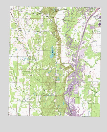
Wren, MS USGS Topographic Map
Click on map above to begin viewing in our Map Viewer.

This topographic map contains these locations and features:
Feature Name Type Latitude Longitude GNIS ID View Map
A G Doss Lake DamDamN33.9168°W88.5567°682396View Map
Acker Lake CutoffChannelN33.8946°W88.5464°687346View Map
Acker Lake Recreation AreaParkN33.8876°W88.5528°687347View Map
Amory Lagoon DamDamN33.9768°W88.5100°682424View Map
Amory West Elementary SchoolSchoolN33.9834°W88.5009°709308View Map
Becker Bottoms Access AreaParkN33.8979°W88.5292°687362View Map
Becker CutoffChannelN33.9407°W88.5345°687363View Map
Bell Mission (historical)ChurchN33.9287°W88.5589°709323View Map
Bells Ferry (historical)CrossingN33.9734°W88.5445°709314View Map
Bransford CemeteryCemeteryN33.9168°W88.6184°667527View Map
Bristo (historical)Populated PlaceN33.9873°W88.5520°687367View Map
Camp WrenwoodsLocaleN33.9957°W88.5634°667994View Map
Charity Hall (historical)SchoolN33.9290°W88.5589°709324View Map
Colberts HillSummitN33.9723°W88.5620°709326View Map
Coon Tail (historical)Populated PlaceN33.9196°W88.5598°687380View Map
Coontail Road Access AreaParkN33.9334°W88.5367°687381View Map
Cotton Gin Ferry (historical)CrossingN33.9718°W88.5470°709328View Map
Cotton Gin Port (historical)Populated PlaceN33.9709°W88.5431°709329View Map
Cotton Hill Gin EstatesPopulated PlaceN33.9779°W88.5681°687383View Map
Cowpen CreekStreamN33.8768°W88.6112°668909View Map
Drummond Branch CutoffChannelN33.9018°W88.5478°687388View Map
Fields Ferry (historical)CrossingN33.9723°W88.5464°687394View Map
Grace Baptist ChapelChurchN33.9096°W88.5606°670561View Map
Gradys Chapel United Methodist ChurchChurchN33.9923°W88.5842°670566View Map
Greenbrier BranchStreamN33.9046°W88.5025°670686View Map
H R Broadhead Pond DamDamN33.8868°W88.5500°682385View Map
Halfway Creek Access AreaParkN33.8793°W88.5209°687413View Map
Haughton Memorial ParkCemeteryN33.9893°W88.5056°671013View Map
James Jenkins Lake DamDamN33.9984°W88.5684°682434View Map
John T Smallwood Pond DamDamN33.9301°W88.5517°682407View Map
Lake MarthaReservoirN33.9521°W88.6016°682414View Map
Lake Martha DamDamN33.9534°W88.6017°682415View Map
Lake MonroeReservoirN33.9473°W88.5664°673733View Map
Lake Monroe DamDamN33.9418°W88.5667°682410View Map
Lake Monroe East SubdivisionPopulated PlaceN33.9432°W88.5639°687424View Map
Lake Monroe West SubdivisionPopulated PlaceN33.9459°W88.5703°687425View Map
Lawrence (historical)Populated PlaceN33.9718°W88.6209°687427View Map
League ChapelChurchN33.8979°W88.5603°672339View Map
Lou Anna S Paine Pond DamDamN33.9234°W88.5700°682399View Map
Lusbys Ferry (historical)CrossingN33.9773°W88.5417°687430View Map
Moccasin CreekStreamN33.8809°W88.5220°673722View Map
Moccasin SloughSwampN33.9050°W88.5100°673724View Map
Mound CemeteryCemeteryN33.9698°W88.5073°673900View Map
Mount Moriah Missionary Baptist ChurchChurchN33.8934°W88.5964°674076View Map
Mount Olive Missionary Baptist ChurchChurchN33.9209°W88.5956°674157View Map
New Hope CemeteryCemeteryN33.9143°W88.5617°687444View Map
New Hope Christian ChurchChurchN33.9165°W88.5617°674727View Map
New Point ChurchChurchN33.9118°W88.5120°674798View Map
New WrenPopulated PlaceN33.9718°W88.6134°674860View Map
North Mississippi Worship CenterChurchN33.9809°W88.5795°687445View Map
Old French Fort (historical)MilitaryN33.9889°W88.5508°1681363View Map
Presbyterian Lake DamDamN33.9001°W88.5667°682391View Map
Roundhouse BranchStreamN33.9515°W88.5306°676922View Map
Roundhouse Branch CutoffChannelN33.9504°W88.5292°687456View Map
Supervisor District 5CivilN33.9754°W88.6247°711991View Map
Thompson CemeteryCemeteryN33.8879°W88.5578°678696View Map
Thompson Memorial Methodist Church (historical)ChurchN33.8873°W88.5587°709399View Map
Town CreekStreamN33.9890°W88.5473°678845View Map
TranquilPopulated PlaceN33.9423°W88.5995°709400View Map
Tranquil United Methodist ChurchChurchN33.9426°W88.5978°678855View Map
Waltons Ferry (historical)CrossingN33.9871°W88.5514°687478View Map
Weaver CreekStreamN33.9368°W88.5323°679410View Map
WHAY-FM (Aberdeen)TowerN33.9223°W88.5570°680252View Map
WrenPopulated PlaceN33.9718°W88.5998°679885View Map
Wren CemeteryCemeteryN33.9784°W88.6009°679887View Map
Wren Church of ChristChurchN33.9868°W88.6200°709409View Map
Wren Community Center and LibraryBuildingN33.9709°W88.6145°687487View Map
Wren Consolidated SchoolSchoolN33.9715°W88.6145°687488View Map
Wren Presbyterian ChurchChurchN33.9751°W88.6131°679888View Map
Wren Volunteer Fire Department Station 1BuildingN33.9710°W88.6146°2665888View Map

Note: Coordinates in the location and feature list above are referenced to NAD83 datum.


Copyright (C) 2008-2025 Ryan Niemi / Sunset Dynamics ... All Rights Reserved