TopoQuest Logo
Do you find TopoQuest useful?
Help keep TopoQuest running and adding new maps/features by donating!
Bitcoin:  19c7KJd3qBynnjoSw5npx9KScwjBe4ifkT
Litecoin:  LXs6TkuXGGXo1vDsWCkWVdjQX94eUKd6ui
Home View Maps Find Maps Find Places Resources & Links


Black Butte, Oregon Topographic Map

USGS Map Title: Black Butte, OR
USGS Map MRC: 44121D6
DRG (GeoTIFF) Download: o44121d6.tif


Neighboring USGS Topographic Map Quads:


  Marion Lake, OR  
44121E7
 

  Candle Creek, OR  
44121E6
 

  Prairie Farm Spring, OR  
44121E5
 

  Three Fingered Jack, OR  
44121D7
 

  Black Butte, OR  
44121D6
 

  Little Squaw Back, OR  
44121D5
 

  Mount Washington, OR  
44121C7
 

  Black Crater, OR  
44121C6
 

  Sisters, OR  
44121C5


Map MRC Location:

N45°
W122°
N45°
W121°
H8 H7 H6 H5 H4 H3 H2 H1
G8 G7 G6 G5 G4 G3 G2 G1
F8 F7 F6 F5 F4 F3 F2 F1
E8 E7 E6 E5 E4 E3 E2 E1
D8 D7 D6 D5 D4 D3 D2 D1
C8 C7 C6 C5 C4 C3 C2 C1
B8 B7 B6 B5 B4 B3 B2 B1
A8 A7 A6 A5 A4 A3 A2 A1
N44°
W122°
N44°
W121°

Black Butte, OR USGS 1:24K Topographic Map Preview:
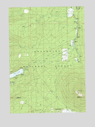
Black Butte, OR USGS Topographic Map
Click on map above to begin viewing in our Map Viewer.

This topographic map contains these locations and features:
Feature Name Type Latitude Longitude GNIS ID View Map
Allingham Guard StationLocaleN44.4732°W121.6381°1137155View Map
Allingham Recreation SiteLocaleN44.4721°W121.6359°1156762View Map
Black ButteSummitN44.3996°W121.6357°1138174View Map
Black Butte Elementary SchoolSchoolN44.4601°W121.6468°1138181View Map
Black Butte Lookout StationLocaleN44.4001°W121.6367°1167291View Map
Black Butte RanchPopulated PlaceN44.3773°W121.6537°1138180View Map
Black Butte Ranch Post OfficePost OfficeN44.3771°W121.6534°1164923View Map
Black Butte Ranch Wastewater Treatment PlantLocaleN44.3778°W121.6658°2697039View Map
Blue Bay Campground Boat RampLocaleN44.4214°W121.7313°2700056View Map
Blue Bay Recreation SiteLocaleN44.4207°W121.7345°1156876View Map
Cache CreekStreamN44.4387°W121.6634°1139125View Map
Camp ShermanPopulated PlaceN44.4604°W121.6412°1139266View Map
Camp Sherman Census Designated PlaceCensusN44.4493°W121.6496°2584410View Map
Camp Sherman Fire DepartmentBuildingN44.4498°W121.6543°2577099View Map
Camp Sherman Post OfficePost OfficeN44.4599°W121.6430°1165004View Map
Camp Sherman Recreation SiteLocaleN44.4637°W121.6392°1156269View Map
Cinder Beach Recreation SiteLocaleN44.4282°W121.7309°1926209View Map
Circle M RanchLocaleN44.4918°W121.6514°1139740View Map
Cold SpringsSpringN44.4538°W121.6484°1139968View Map
Davis CreekStreamN44.4659°W121.6387°1140656View Map
Dry CreekStreamN44.3912°W121.6962°1141301View Map
First CreekStreamN44.4843°W121.6387°1142137View Map
Gorge Recreation SiteLocaleN44.4860°W121.6401°1156877View Map
Head of Jack CreekLocaleN44.4721°W121.7264°1156274View Map
Head of Metolius Recreation SiteLocaleN44.4357°W121.6381°1926214View Map
Head of the MetoliusSpringN44.4342°W121.6398°1167290View Map
House on the Metolius ResortLocaleN44.4885°W121.6445°1156273View Map
Jack CreekStreamN44.4935°W121.6473°1144161View Map
Jack Creek Recreation SiteLocaleN44.4868°W121.6967°1156272View Map
Lake CreekStreamN44.4362°W121.7026°1144755View Map
Lake Creek LodgeLocaleN44.4459°W121.6556°1156270View Map
Matoles Post Office (historical)Post OfficeN44.4415°W121.6581°1164499View Map
Methodist Youth CampLocaleN44.4254°W121.7256°1156264View Map
Metolius SpringSpringN44.4342°W121.6380°1146119View Map
Middle Fork Lake CreekStreamN44.4415°W121.6612°1146150View Map
North Fork Lake CreekStreamN44.4565°W121.6428°1146971View Map
Pine Rest Recreation SiteLocaleN44.4790°W121.6364°1147720View Map
River Island Forest Camp (historical)LocaleN44.4679°W121.6401°1156763View Map
Riverside Recreation SiteLocaleN44.4359°W121.6370°1148493View Map
Scout LakeLakeN44.4100°W121.7471°1149186View Map
Scout Lake Group CampLocaleN44.4110°W121.7473°1149189View Map
Smiling River Recreation SiteLocaleN44.4748°W121.6345°1156764View Map
South Fork Lake CreekStreamN44.4529°W121.6428°1149983View Map
South Shore Campground Boat RampLocaleN44.4199°W121.7392°2700090View Map
South Shore Recreation SiteLocaleN44.4179°W121.7414°1150079View Map
Spring CreekStreamN44.4554°W121.6445°1155347View Map
Suttle LakeLakeN44.4216°W121.7408°1150712View Map
Suttle Lake Forest Service StationLocaleN44.4265°W121.7248°1116562View Map
Suttle Lake ResortLocaleN44.4265°W121.7284°1167292View Map
Suttle Lake Resort DockLocaleN44.4255°W121.7289°2699853View Map

Note: Coordinates in the location and feature list above are referenced to NAD83 datum.


Copyright (C) 2008-2024 Ryan Niemi / Sunset Dynamics ... All Rights Reserved