TopoQuest Logo
Do you find TopoQuest useful?
Help keep TopoQuest running and adding new maps/features by donating!
Bitcoin:  19c7KJd3qBynnjoSw5npx9KScwjBe4ifkT
Litecoin:  LXs6TkuXGGXo1vDsWCkWVdjQX94eUKd6ui
Home View Maps Find Maps Find Places Resources & Links


Shoals, Indiana Topographic Map

USGS Map Title: Shoals, IN
USGS Map MRC: 38086F7
DRG (GeoTIFF) Download: o38086f7.tif


Neighboring USGS Topographic Map Quads:


  Odon, IN  
38086G8
 

  Indian Springs, IN  
38086G7
 

  Williams, IN  
38086G6
 

  Loogootee, IN  
38086F8
 

  Shoals, IN  
38086F7
 

  Huron, IN  
38086F6
 

  Alfordsville, IN  
38086E8
 

  Rusk, IN  
38086E7
 

  Hillham, IN  
38086E6


Map MRC Location:

N39°
W87°
N39°
W86°
H8 H7 H6 H5 H4 H3 H2 H1
G8 G7 G6 G5 G4 G3 G2 G1
F8 F7 F6 F5 F4 F3 F2 F1
E8 E7 E6 E5 E4 E3 E2 E1
D8 D7 D6 D5 D4 D3 D2 D1
C8 C7 C6 C5 C4 C3 C2 C1
B8 B7 B6 B5 B4 B3 B2 B1
A8 A7 A6 A5 A4 A3 A2 A1
N38°
W87°
N38°
W86°

Shoals, IN USGS 1:24K Topographic Map Preview:
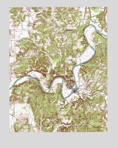
Shoals, IN USGS Topographic Map
Click on map above to begin viewing in our Map Viewer.

This topographic map contains these locations and features:
Feature Name Type Latitude Longitude GNIS ID View Map
American RunStreamN38.6306°W86.8344°450628View Map
Beaver CreekStreamN38.6570°W86.7519°450664View Map
Beech CreekStreamN38.6737°W86.8367°450669View Map
Branch RunStreamN38.7142°W86.8031°450701View Map
Buck KnobSummitN38.7342°W86.8306°450728View Map
Buck Knob CreekStreamN38.7392°W86.8450°450729View Map
Buzzard RunStreamN38.6784°W86.8747°450744View Map
Cedar BluffCliffN38.6928°W86.7950°450760View Map
Cedar BrookStreamN38.6920°W86.7906°450761View Map
Chalybeate SpringsSpringN38.7092°W86.8514°451786View Map
Church BrookStreamN38.6937°W86.8194°450776View Map
Dover HillPopulated PlaceN38.7251°W86.8028°450862View Map
Dover Hill Census Designated PlaceCensusN38.7221°W86.8002°2583449View Map
Dover RunStreamN38.7284°W86.7981°450863View Map
Flood RunStreamN38.6934°W86.7844°450919View Map
Free RunStreamN38.7128°W86.7633°450932View Map
Freemans Spring BranchStreamN38.7092°W86.7686°450935View Map
French RunStreamN38.6256°W86.8356°450941View Map
Friendship ChurchChurchN38.6959°W86.8069°450943View Map
Grove BrookStreamN38.6295°W86.8461°450986View Map
Gushing CreekStreamN38.6601°W86.7850°450991View Map
Hall CemeteryCemeteryN38.6564°W86.8253°450999View Map
Heathen BendBendN38.7278°W86.7736°451024View Map
Henry CreekStreamN38.7217°W86.7528°436031View Map
Hickory RidgeRidgeN38.7139°W86.7925°451033View Map
Hickory RunStreamN38.6876°W86.7950°451036View Map
Hill BranchStreamN38.7267°W86.8206°451039View Map
Hindostan ChurchChurchN38.6326°W86.8531°451044View Map
Houghton RunStreamN38.6412°W86.8706°451065View Map
House RockSummitN38.6806°W86.7956°451067View Map
House Rock BranchStreamN38.6923°W86.7844°451068View Map
Indian CreekStreamN38.7267°W86.7622°451082View Map
Indian RunStreamN38.6342°W86.8342°451086View Map
Iron CreekStreamN38.6581°W86.7725°451088View Map
IrontonPopulated PlaceN38.6623°W86.7753°451089View Map
Jet RunStreamN38.6523°W86.7981°451101View Map
Knob BranchStreamN38.7400°W86.8442°451121View Map
LacyPopulated PlaceN38.6337°W86.7764°451128View Map
Lacy DrainStreamN38.6309°W86.7889°451129View Map
Leaf BranchStreamN38.7026°W86.8100°451136View Map
Lemon RunStreamN38.6298°W86.8125°451138View Map
Limb RunStreamN38.7145°W86.7997°451146View Map
Lime RunStreamN38.6264°W86.8158°451147View Map
Martin CountyCivilN38.7080°W86.8031°451679View Map
Martin County Civil Defense and Fire DepartmentBuildingN38.6827°W86.8733°2701384View Map
Martin County JailBuildingN38.6698°W86.7963°2758489View Map
Martin County Sheriff's OfficeBuildingN38.6696°W86.7964°2758059View Map
Martin County State ForestForestN38.7001°W86.7556°449805View Map
McBrides BluffCliffN38.7264°W86.7803°451204View Map
McBrides CemeteryCemeteryN38.7314°W86.7761°451205View Map
Mount Union ChurchChurchN38.7081°W86.8403°451263View Map
Mountain StreamStreamN38.7095°W86.8617°451261View Map
Nest BrookStreamN38.6917°W86.8603°451272View Map
Nubbin Ridge BranchStreamN38.6703°W86.8219°451285View Map
Nut BrookStreamN38.6887°W86.8222°451286View Map
Opossum CreekStreamN38.7495°W86.7592°451303View Map
Overlook DrainStreamN38.6781°W86.7928°451309View Map
Peek CutGapN38.6851°W86.8186°451323View Map
Peek RunStreamN38.6878°W86.8233°451324View Map
Pinnacle RockPillarN38.6753°W86.7931°451337View Map
Pleasant ValleyPopulated PlaceN38.6320°W86.8014°451347View Map
Poplar Grove ChurchChurchN38.6614°W86.8628°451357View Map
River DrainStreamN38.6814°W86.8494°451398View Map
Root BrookStreamN38.7067°W86.8111°451406View Map
Sampson HillSummitN38.6389°W86.7886°451429View Map
Seed Tick CreekStreamN38.7228°W86.8611°451442View Map
Shell MoundSummitN38.6578°W86.8078°451777View Map
Sherfick StreamStreamN38.6581°W86.7808°451450View Map
ShoalsPopulated PlaceN38.6664°W86.7911°443428View Map
Shoals Community Elementary SchoolSchoolN38.6687°W86.7772°451747View Map
Shoals Community High SchoolSchoolN38.6687°W86.7772°451745View Map
Shoals Community Middle SchoolSchoolN38.6687°W86.7772°451746View Map
Shoals OverlookPopulated PlaceN38.6795°W86.8044°451456View Map
Shoals Town MarshalBuildingN38.6649°W86.7907°2758256View Map
Shoals Volunteer Fire DepartmentBuildingN38.6643°W86.7904°2625846View Map
Sholts CemeteryCemeteryN38.6389°W86.8311°451458View Map
Sod RunStreamN38.7284°W86.8581°451477View Map
Speel CreekStreamN38.6703°W86.7892°451490View Map
Spout SpringSpringN38.6552°W86.8049°451493View Map
Spurt RunStreamN38.6539°W86.8014°451503View Map
Squirt RunStreamN38.6548°W86.7967°451504View Map
Steep Hollow CemeteryCemeteryN38.7437°W86.7878°444113View Map
Sum CreekStreamN38.7342°W86.7875°451530View Map
Town of ShoalsCivilN38.6668°W86.7940°2397661View Map
Township of CenterCivilN38.6767°W86.8256°453188View Map
Union CreekStreamN38.7275°W86.8561°451590View Map
Windy RunStreamN38.6501°W86.8519°451640View Map

Note: Coordinates in the location and feature list above are referenced to NAD83 datum.


Copyright (C) 2008-2025 Ryan Niemi / Sunset Dynamics ... All Rights Reserved