TopoQuest Logo
Do you find TopoQuest useful?
Help keep TopoQuest running and adding new maps/features by donating!
Bitcoin:  19c7KJd3qBynnjoSw5npx9KScwjBe4ifkT
Litecoin:  LXs6TkuXGGXo1vDsWCkWVdjQX94eUKd6ui
Home View Maps Find Maps Find Places Resources & Links


Loogootee, Indiana Topographic Map

USGS Map Title: Loogootee, IN
USGS Map MRC: 38086F8
DRG (GeoTIFF) Download: o38086f8.tif


Neighboring USGS Topographic Map Quads:


  Epsom, IN  
38087G1
 

  Odon, IN  
38086G8
 

  Indian Springs, IN  
38086G7
 

  Montgomery, IN  
38087F1
 

  Loogootee, IN  
38086F8
 

  Shoals, IN  
38086F7
 

  Glendale, IN  
38087E1
 

  Alfordsville, IN  
38086E8
 

  Rusk, IN  
38086E7


Map MRC Location:

N39°
W87°
N39°
W86°
H8 H7 H6 H5 H4 H3 H2 H1
G8 G7 G6 G5 G4 G3 G2 G1
F8 F7 F6 F5 F4 F3 F2 F1
E8 E7 E6 E5 E4 E3 E2 E1
D8 D7 D6 D5 D4 D3 D2 D1
C8 C7 C6 C5 C4 C3 C2 C1
B8 B7 B6 B5 B4 B3 B2 B1
A8 A7 A6 A5 A4 A3 A2 A1
N38°
W87°
N38°
W86°

Loogootee, IN USGS 1:24K Topographic Map Preview:
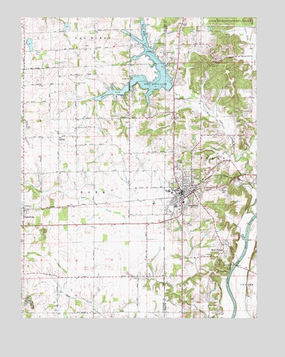
Loogootee, IN USGS Topographic Map
Click on map above to begin viewing in our Map Viewer.

This topographic map contains these locations and features:
Feature Name Type Latitude Longitude GNIS ID View Map
All Saints ChurchChurchN38.6712°W86.9989°430079View Map
Boggs CreekStreamN38.6678°W86.8756°450691View Map
Brook CemeteryCemeteryN38.6498°W86.8944°431564View Map
CannelburgPopulated PlaceN38.6698°W86.9983°449631View Map
Cedar Grove ChurchChurchN38.7225°W86.9700°432271View Map
City of LoogooteeCivilN38.6759°W86.9143°2395763View Map
Goodwill CemeteryCemeteryN38.6884°W86.9158°435174View Map
Graber Poultry FarmLocaleN38.6975°W86.9778°2635429View Map
Houghton BridgeBridgeN38.6470°W86.8861°436517View Map
Houghton CemeteryCemeteryN38.6509°W86.8975°436518View Map
LoogooteePopulated PlaceN38.6770°W86.9142°438296View Map
Loogootee Fire DepartmentBuildingN38.6674°W86.9185°2625672View Map
Loogootee High SchoolSchoolN38.6778°W86.9214°447370View Map
Loogootee Police DepartmentBuildingN38.6786°W86.9160°2758429View Map
Loogootee Volunteer Fire DepartmentBuildingN38.6787°W86.9159°2625776View Map
Love CemeteryCemeteryN38.7067°W86.8856°438343View Map
Mount Calvary ChurchChurchN38.7303°W86.8997°439529View Map
Mount PleasantPopulated PlaceN38.6520°W86.8922°439638View Map
Prairie Creek Structure Number A-2-1LakeN38.7389°W86.9951°447264View Map
Prairie Creek Structure Number A-2-2LakeN38.7466°W86.9757°447265View Map
Saint John Lutheran SchoolSchoolN38.6784°W86.9078°453069View Map
Saint Johns CemeteryCemeteryN38.6853°W86.9086°442569View Map
Saint Marys ChurchChurchN38.7084°W86.9433°442701View Map
Scenic HillPopulated PlaceN38.6784°W86.8939°443061View Map
Shurn CreekStreamN38.7206°W86.9206°443471View Map
Southeast Center SchoolSchoolN38.6998°W86.9803°443872View Map
Town of CannelburgCivilN38.6679°W86.9974°2396626View Map
Wagler CemeteryCemeteryN38.7042°W86.9972°445349View Map
West Boggs CreekStreamN38.6923°W86.8850°445716View Map
West Boggs Creek DamDamN38.7204°W86.9205°448536View Map
West Boggs LakeReservoirN38.7260°W86.9247°445717View Map
West Boggs ParkParkN38.7359°W86.9264°445718View Map
Woods CemeteryCemeteryN38.7164°W86.9142°446307View Map
Zion ChurchChurchN38.7467°W86.9986°446452View Map

Note: Coordinates in the location and feature list above are referenced to NAD83 datum.


Copyright (C) 2008-2024 Ryan Niemi / Sunset Dynamics ... All Rights Reserved