TopoQuest Logo
Do you find TopoQuest useful?
Help keep TopoQuest running and adding new maps/features by donating!
Bitcoin:  19c7KJd3qBynnjoSw5npx9KScwjBe4ifkT
Litecoin:  LXs6TkuXGGXo1vDsWCkWVdjQX94eUKd6ui
Home View Maps Find Maps Find Places Resources & Links


Shubuta, Mississippi Topographic Map

USGS Map Title: Shubuta, MS
USGS Map MRC: 31088G6
DRG (GeoTIFF) Download: o31088g6.tif


Neighboring USGS Topographic Map Quads:


  Hale, MS  
31088H7
 

  De Soto, MS  
31088H6
 

  Carmichael, MS  
31088H5
 

  Eucutta, MS  
31088G7
 

  Shubuta, MS  
31088G6
 

  Matherville, MS  
31088G5
 

  Whistler, MS  
31088F7
 

  Waynesboro, MS  
31088F6
 

  Denham, MS  
31088F5


Map MRC Location:

N32°
W89°
N32°
W88°
H8 H7 H6 H5 H4 H3 H2 H1
G8 G7 G6 G5 G4 G3 G2 G1
F8 F7 F6 F5 F4 F3 F2 F1
E8 E7 E6 E5 E4 E3 E2 E1
D8 D7 D6 D5 D4 D3 D2 D1
C8 C7 C6 C5 C4 C3 C2 C1
B8 B7 B6 B5 B4 B3 B2 B1
A8 A7 A6 A5 A4 A3 A2 A1
N31°
W89°
N31°
W88°

Shubuta, MS USGS 1:24K Topographic Map Preview:
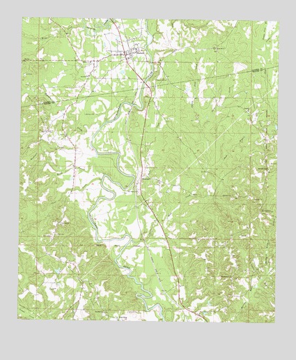
Shubuta, MS USGS Topographic Map
Click on map above to begin viewing in our Map Viewer.

This topographic map contains these locations and features:
Feature Name Type Latitude Longitude GNIS ID View Map
Atkinson CemeteryCemeteryN31.8027°W88.6517°666418View Map
Beautiful Church (historical)ChurchN31.8002°W88.7475°684059View Map
Bent ChurchChurchN31.8268°W88.7278°666832View Map
Brownlee Spur (historical)LocaleN31.7813°W88.6875°684061View Map
Carson Sand CreekStreamN31.7835°W88.6956°668104View Map
Chaparral CemeteryCemeteryN31.8377°W88.6398°706417View Map
Chaparral ChurchChurchN31.8377°W88.6395°668311View Map
Chaparral Oil FieldOilfieldN31.8374°W88.6356°668312View Map
Chaparral School (historical)SchoolN31.8143°W88.6295°684066View Map
Chapparrell (historical)LocaleN31.8357°W88.6389°706418View Map
Clear CreekStreamN31.8082°W88.7098°668556View Map
Clear Creek CemeteryCemeteryN31.7896°W88.7303°706421View Map
Clear Creek ChurchChurchN31.7904°W88.7303°668569View Map
Davis School (historical)SchoolN31.7763°W88.7373°684074View Map
Diamond Oil FieldOilfieldN31.7643°W88.6281°669250View Map
Dicks CreekStreamN31.7835°W88.6906°669264View Map
Double Fork BranchStreamN31.8657°W88.6314°669346View Map
East Yellow Creek Oil FieldOilfieldN31.7602°W88.7156°669616View Map
Eucutta CreekStreamN31.8296°W88.7112°669820View Map
Garland Creek Oil FieldOilfieldN31.8668°W88.6820°709432View Map
Graham Pond DamDamN31.7702°W88.7300°680883View Map
Greenhill Baptist ChurchChurchN31.8632°W88.6553°670672View Map
HiwanneePopulated PlaceN31.8102°W88.6906°671248View Map
Hiwannee Lookout TowerTowerN31.7965°W88.6309°711247View Map
Julie CreekStreamN31.8302°W88.6617°672051View Map
MacDavid Millpond BranchStreamN31.7699°W88.6292°672980View Map
Menasco CemeteryCemeteryN31.8354°W88.7186°673475View Map
Menasco School (historical)SchoolN31.8549°W88.7448°687538View Map
Menasen Church (historical)ChurchN31.8549°W88.7445°709446View Map
Methodist ChapelChurchN31.8138°W88.6292°673508View Map
Mingo CreekStreamN31.8710°W88.7198°673676View Map
New Hope CemeteryCemeteryN31.7532°W88.7081°706438View Map
New Hope ChurchChurchN31.7535°W88.7081°674687View Map
New Pilgrim ChurchChurchN31.8035°W88.6925°674796View Map
Nickleson CreekStreamN31.8268°W88.7200°674921View Map
North Yellow Creek Oil FieldOilfieldN31.8346°W88.7406°674967View Map
Pleasant Grove ChurchChurchN31.7685°W88.6464°676000View Map
Pleasant Grove ChurchChurchN31.8499°W88.6848°676003View Map
Red Level School (historical)SchoolN31.8029°W88.7245°684098View Map
Reedy BranchStreamN31.8107°W88.7081°676570View Map
Salem ChurchChurchN31.8279°W88.7362°677274View Map
Sanctified ChurchChurchN31.8513°W88.7170°677318View Map
Sand BranchStreamN31.8124°W88.6595°677326View Map
ShubutaPopulated PlaceN31.8602°W88.6995°677756View Map
Shubuta CemeteryCemeteryN31.8632°W88.6909°709472View Map
Shubuta City Police DepartmentBuildingN31.8604°W88.6977°2754295View Map
Shubuta City Volunteer Fire DepartmentBuildingN31.8564°W88.6986°2667862View Map
Shubuta Oil FieldOilfieldN31.8502°W88.7306°709473View Map
Shubuta Post OfficePost OfficeN31.8589°W88.6997°2768582View Map
Shubuta SchoolSchoolN31.8571°W88.7162°677757View Map
Silver LakeLakeN31.7760°W88.7228°684105View Map
Supervisor District 3CivilN31.7934°W88.6514°712131View Map
Thompsons Mill (historical)LocaleN31.7918°W88.6709°684107View Map
Town of ShubutaCivilN31.8620°W88.7021°2407330View Map
Wayne County Volunteer Fire Department Hiwanee StationBuildingN31.7936°W88.6845°2667884View Map
Wayne County Volunteer Fire Department Yellow Creek StationBuildingN31.7659°W88.7177°2667994View Map
West KingPopulated PlaceN31.7507°W88.7009°692314View Map
West King Junction (historical)LocaleN31.7563°W88.6714°684126View Map

Note: Coordinates in the location and feature list above are referenced to NAD83 datum.


Copyright (C) 2008-2024 Ryan Niemi / Sunset Dynamics ... All Rights Reserved