TopoQuest Logo
Do you find TopoQuest useful?
Help keep TopoQuest running and adding new maps/features by donating!
Bitcoin:  19c7KJd3qBynnjoSw5npx9KScwjBe4ifkT
Litecoin:  LXs6TkuXGGXo1vDsWCkWVdjQX94eUKd6ui
Home View Maps Find Maps Find Places Resources & Links


Shulerville, South Carolina Topographic Map

USGS Map Title: Shulerville, SC
USGS Map MRC: 33079B6
DRG (GeoTIFF) Download: o33079b6.tif


Neighboring USGS Topographic Map Quads:


  Alvin, SC  
33079C7
 

  Jamestown, SC  
33079C6
 

  Cedar Creek, SC  
33079C5
 

  Bethera, SC  
33079B7
 

  Shulerville, SC  
33079B6
 

  Honey Hill, SC  
33079B5
 

  Huger, SC  
33079A7
 

  Ocean Bay, SC  
33079A6
 

  Awendaw, SC  
33079A5


Map MRC Location:

N34°
W80°
N34°
W79°
H8 H7 H6 H5 H4 H3 H2 H1
G8 G7 G6 G5 G4 G3 G2 G1
F8 F7 F6 F5 F4 F3 F2 F1
E8 E7 E6 E5 E4 E3 E2 E1
D8 D7 D6 D5 D4 D3 D2 D1
C8 C7 C6 C5 C4 C3 C2 C1
B8 B7 B6 B5 B4 B3 B2 B1
A8 A7 A6 A5 A4 A3 A2 A1
N33°
W80°
N33°
W79°

Shulerville, SC USGS 1:24K Topographic Map Preview:
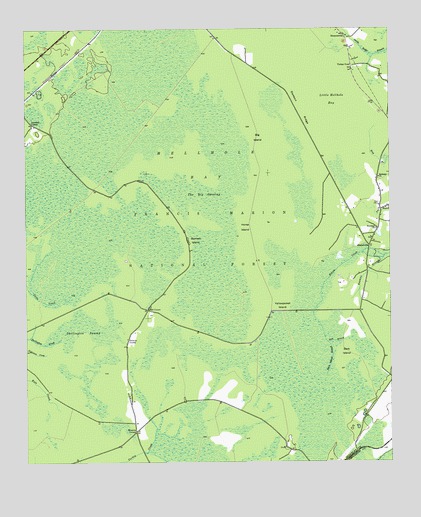
Shulerville, SC USGS Topographic Map
Click on map above to begin viewing in our Map Viewer.

This topographic map contains these locations and features:
Feature Name Type Latitude Longitude GNIS ID View Map
Bark IslandIslandN33.1568°W79.6406°1229376View Map
Bark Island SloughStreamN33.1599°W79.6467°1229377View Map
Barnett IslandIslandN33.1893°W79.6942°1244963View Map
Beaman BranchStreamN33.1846°W79.6265°1229384View Map
Bethany ChurchChurchN33.2074°W79.6284°1246757View Map
Big IslandIslandN33.2171°W79.6698°1229421View Map
Boggy Head BaySwampN33.1910°W79.7321°1229439View Map
Cordesville DivisionCivilN33.1793°W79.7362°1938238View Map
Darlington SwampSwampN33.1619°W79.7349°1247488View Map
Dawson RidgeIslandN33.2268°W79.6553°1229626View Map
Farewell CornerPopulated PlaceN33.2229°W79.7473°1247730View Map
Francis Marion National ForestForestN33.1673°W79.7132°1851865View Map
Gum BranchStreamN33.1596°W79.6467°1229760View Map
Hell Hole Bay WildernessReserveN33.2176°W79.6920°2035149View Map
Hellhole BaySwampN33.2116°W79.6895°1245949View Map
Hellhole Bay WildernessReserveN33.2224°W79.6770°1230588View Map
Horse IslandIslandN33.1929°W79.6748°1229821View Map
Little Hellhole BayBayN33.2299°W79.6440°1246401View Map
New Hope CemeteryCemeteryN33.1921°W79.6295°1234567View Map
New Hope School (historical)SchoolN33.1896°W79.6312°1234571View Map
Newhope ChurchChurchN33.1924°W79.6292°1249866View Map
Oak CornerPopulated PlaceN33.1691°W79.7081°1230116View Map
Peterstand IslandIslandN33.2082°W79.7148°1234588View Map
Round Pond TrailheadLocaleN33.1354°W79.6356°1230587View Map
ShulervillePopulated PlaceN33.1874°W79.6320°1230326View Map
Shulerville Post OfficePost OfficeN33.1991°W79.6284°1252159View Map
SimmonsvillePopulated PlaceN33.2485°W79.6403°1230328View Map
The Big OpeningSwampN33.1989°W79.6888°1251146View Map
Thomas CornerPopulated PlaceN33.1607°W79.7148°1230407View Map
Turkey PondPopulated PlaceN33.2396°W79.6376°1230428View Map
Windom CornerPopulated PlaceN33.1341°W79.7123°1230512View Map
Yellowjacket IslandIslandN33.1721°W79.6631°1251528View Map

Note: Coordinates in the location and feature list above are referenced to NAD83 datum.


Copyright (C) 2008-2025 Ryan Niemi / Sunset Dynamics ... All Rights Reserved