TopoQuest Logo
Do you find TopoQuest useful?
Help keep TopoQuest running and adding new maps/features by donating!
Bitcoin:  19c7KJd3qBynnjoSw5npx9KScwjBe4ifkT
Litecoin:  LXs6TkuXGGXo1vDsWCkWVdjQX94eUKd6ui
Home View Maps Find Maps Find Places Resources & Links


Sigma, Michigan Topographic Map

USGS Map Title: Sigma, MI
USGS Map MRC: 44085F1
DRG (GeoTIFF) Download: o44085f1.tif


Neighboring USGS Topographic Map Quads:


  Leetsville, MI  
44085G2
 

  Westwood, MI  
44085G1
 

  Starvation Lake, MI  
44084G8
 

  Kalkaska, MI  
44085F2
 

  Sigma, MI  
44085F1
 

  Black Creek, MI  
44084F8
 

  Smithville, MI  
44085E2
 

  Sharon, MI  
44085E1
 

  Fletcher, MI  
44084E8


Map MRC Location:

N45°
W86°
N45°
W85°
H8 H7 H6 H5 H4 H3 H2 H1
G8 G7 G6 G5 G4 G3 G2 G1
F8 F7 F6 F5 F4 F3 F2 F1
E8 E7 E6 E5 E4 E3 E2 E1
D8 D7 D6 D5 D4 D3 D2 D1
C8 C7 C6 C5 C4 C3 C2 C1
B8 B7 B6 B5 B4 B3 B2 B1
A8 A7 A6 A5 A4 A3 A2 A1
N44°
W86°
N44°
W85°

Sigma, MI USGS 1:24K Topographic Map Preview:
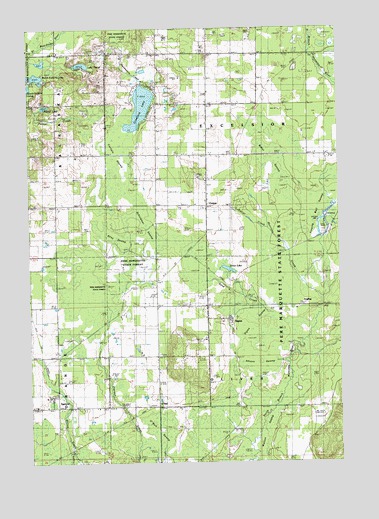
Sigma, MI USGS Topographic Map
Click on map above to begin viewing in our Map Viewer.

This topographic map contains these locations and features:
Feature Name Type Latitude Longitude GNIS ID View Map
Advent SwampSwampN44.6522°W85.0334°619856View Map
AnglingPopulated PlaceN44.6700°W85.0092°1617417View Map
Baker SwampSwampN44.7136°W85.0264°620490View Map
Carlisle SwampSwampN44.7142°W85.0892°622724View Map
Collar CreekStreamN44.6814°W85.0200°623607View Map
CottonPopulated PlaceN44.6992°W85.0534°1617502View Map
Crawford LakeLakeN44.7273°W85.0795°624037View Map
Crawford SchoolSchoolN44.7142°W85.0628°624040View Map
Escelsior Church of ChristChurchN44.7000°W85.0528°2492908View Map
Excelsior CemeteryCemeteryN44.7311°W85.0531°2494760View Map
Excelsior ChurchChurchN44.7320°W85.0523°625723View Map
Excelsior Post Office (historical)Post OfficeN44.7139°W85.0728°2494715View Map
Excelsior Town Hall Historical MarkerParkN44.7278°W85.0533°2494766View Map
Excelsior Township HallBuildingN44.7278°W85.0533°2492917View Map
Flowing Well SwampSwampN44.6961°W85.0106°626195View Map
Kalkaska CountyCivilN44.6847°W85.0903°1622982View Map
Kniss LakeLakeN44.6806°W85.0448°629821View Map
Lake PlacidLakeN44.7395°W85.1030°635067View Map
Lewis SchoolSchoolN44.7433°W85.0631°630354View Map
Maplegrove SchoolSchoolN44.7136°W85.1148°631505View Map
Morrison CreekStreamN44.6725°W85.0073°632720View Map
North Selkirk LakeLakeN44.7360°W85.1223°1618852View Map
O'NeilPopulated PlaceN44.6414°W85.0739°1617753View Map
O'Neil SwampSwampN44.6333°W85.0745°633804View Map
Oliver CemeteryCemeteryN44.6564°W85.0728°634032View Map
Palmer LakeLakeN44.7275°W85.1182°634314View Map
Riley SwampSwampN44.6903°W85.0923°635942View Map
Sand CreekStreamN44.6714°W85.0362°637165View Map
Schlemmer SwampSwampN44.6953°W85.0792°637341View Map
SigmaPopulated PlaceN44.6700°W85.0534°637890View Map
Sigma Post Office (historical)Post OfficeN44.6664°W85.0533°2492997View Map
Sigma SchoolSchoolN44.6697°W85.0645°637891View Map
Sigma Station (historical)LocaleN44.6667°W85.0433°2492989View Map
Sigma SwampSwampN44.6617°W85.0328°637892View Map
SpencerPopulated PlaceN44.6414°W85.1148°638494View Map
Spencer Church of ChristChurchN44.6442°W85.1189°2494743View Map
Spencer Post Office (historical)Post OfficeN44.6414°W85.1147°2492994View Map
Spencer Station (historical)LocaleN44.6444°W85.1144°2492988View Map
Timber Wolf Golf ClubLocaleN44.7119°W85.0569°2494765View Map
Township of ExcelsiorCivilN44.7279°W85.0323°1626260View Map
Township of OliverCivilN44.6408°W85.0331°1626843View Map
Watson SwampSwampN44.6333°W85.0292°1615882View Map
WGTU-TV (Traverse City)TowerN44.7483°W85.0689°1625550View Map
Wilderness Christian Assembly ChurchChurchN44.6703°W85.0794°2492913View Map

Note: Coordinates in the location and feature list above are referenced to NAD83 datum.


Copyright (C) 2008-2025 Ryan Niemi / Sunset Dynamics ... All Rights Reserved