TopoQuest Logo
Do you find TopoQuest useful?
Help keep TopoQuest running and adding new maps/features by donating!
Bitcoin:  19c7KJd3qBynnjoSw5npx9KScwjBe4ifkT
Litecoin:  LXs6TkuXGGXo1vDsWCkWVdjQX94eUKd6ui
Home View Maps Find Maps Find Places Resources & Links


Sign Camp Mountain, New Mexico Topographic Map

USGS Map Title: Sign Camp Mountain, NM
USGS Map MRC: 33108E6
DRG (GeoTIFF) Download: o33108e6.tif


Neighboring USGS Topographic Map Quads:


  Reserve, NM  
33108F7
 

  Milligan Mountain, NM  
33108F6
 

  Eagle Peak, NM  
33108F5
 

  O Block Canyon, NM  
33108E7
 

  Sign Camp Mountain, NM  
33108E6
 

  Telephone Canyon, NM  
33108E5
 

  Mogollon, NM  
33108D7
 

  Bearwallow Mountain, NM  
33108D6
 

  Negrito Mountain, NM  
33108D5


Map MRC Location:

N34°
W109°
N34°
W108°
H8 H7 H6 H5 H4 H3 H2 H1
G8 G7 G6 G5 G4 G3 G2 G1
F8 F7 F6 F5 F4 F3 F2 F1
E8 E7 E6 E5 E4 E3 E2 E1
D8 D7 D6 D5 D4 D3 D2 D1
C8 C7 C6 C5 C4 C3 C2 C1
B8 B7 B6 B5 B4 B3 B2 B1
A8 A7 A6 A5 A4 A3 A2 A1
N33°
W109°
N33°
W108°

Sign Camp Mountain, NM USGS 1:24K Topographic Map Preview:
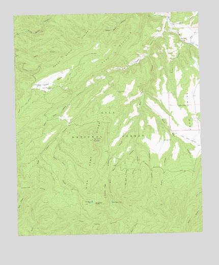
Sign Camp Mountain, NM USGS Topographic Map
Click on map above to begin viewing in our Map Viewer.

This topographic map contains these locations and features:
Feature Name Type Latitude Longitude GNIS ID View Map
Apache Peak TrailTrailN33.5739°W108.7445°903237View Map
Bear TankReservoirN33.6024°W108.6990°903682View Map
Blackdeer RidgeRidgeN33.5253°W108.6912°903900View Map
Bull Basin CanyonValleyN33.6009°W108.6603°904169View Map
Bull Basin TankReservoirN33.5181°W108.6863°904171View Map
Burro CanyonValleyN33.6101°W108.6381°904233View Map
Burro TankReservoirN33.5712°W108.6389°904247View Map
Chimney Canyon TankReservoirN33.6245°W108.6943°913169View Map
Christmas Tree TankReservoirN33.5126°W108.7033°912983View Map
Cicnega SpringSpringN33.5380°W108.6530°912985View Map
Cienega TankReservoirN33.5526°W108.6507°905160View Map
Cougar TankReservoirN33.5407°W108.7062°913156View Map
Cowboy TankReservoirN33.5951°W108.6713°913162View Map
Crossing TankReservoirN33.5483°W108.7116°913155View Map
Deep Creek DivideRidgeN33.5051°W108.6976°905664View Map
Granny CanyonValleyN33.5553°W108.6448°906690View Map
Grayback TankReservoirN33.5294°W108.7057°913157View Map
Indian TankReservoirN33.5793°W108.7055°913163View Map
Kiehne RanchLocaleN33.6098°W108.6376°907550View Map
Long Mesa TankReservoirN33.5516°W108.6868°912984View Map
Lower Sheep Basin TankReservoirN33.5831°W108.7255°908288View Map
Mogollon DivideRidgeN33.5264°W108.7398°908824View Map
Naranjo CanyonValleyN33.5517°W108.6701°909017View Map
North Fork Negrito CreekStreamN33.6070°W108.6312°909147View Map
Oak SpringSpringN33.5206°W108.6531°912987View Map
Old Cabin SpringSpringN33.5310°W108.6500°912986View Map
Olla TankReservoirN33.5806°W108.6809°909353View Map
Pistol CanyonValleyN33.5487°W108.6706°909739View Map
Potato Patch CanyonValleyN33.5564°W108.7220°909814View Map
Rainy MesaSummitN33.5648°W108.6323°909967View Map
Rainy Mesa Airstrip (historical)AirportN33.5487°W108.6259°912794View Map
Rainy Mesa CanyonValleyN33.5742°W108.6648°909969View Map
Rainy Mesa DivideRidgeN33.5306°W108.6253°912793View Map
Red Bull CanyonValleyN33.5431°W108.6781°910040View Map
Reserve DivisionCivilN33.5852°W108.7275°1937576View Map
Russ CanyonValleyN33.6184°W108.6440°910475View Map
Russ MountainRidgeN33.6064°W108.6812°910476View Map
Russ TankReservoirN33.6043°W108.6738°913161View Map
Sheep BasinBasinN33.5864°W108.7253°910981View Map
Sheep Basin DivideRidgeN33.6031°W108.7126°910983View Map
Sheep Basin TankReservoirN33.5848°W108.7353°910984View Map
Shotgun CanyonValleyN33.5614°W108.6690°911025View Map
Sign CampRidgeN33.5476°W108.6984°911046View Map
Sign Camp CanyonValleyN33.6209°W108.6462°911047View Map
Sign Camp MountainSummitN33.5534°W108.6987°911048View Map
Sign Camp RidgeRidgeN33.5534°W108.6987°1744571View Map
Six-shooter SaddleGapN33.5178°W108.6981°911101View Map
Six-shooter TankReservoirN33.5185°W108.7003°911102View Map
Snow TankReservoirN33.5230°W108.7201°913152View Map
South Fork Negrito CreekStreamN33.6070°W108.6312°911238View Map
Turkey TankReservoirN33.5404°W108.7377°913160View Map
Twin Peaks TankReservoirN33.5037°W108.7084°913154View Map
Upper Devils TankReservoirN33.5122°W108.7303°913153View Map
West Sign Camp CanyonValleyN33.5901°W108.6870°912258View Map
West Sign Camp TankReservoirN33.5601°W108.7371°913159View Map

Note: Coordinates in the location and feature list above are referenced to NAD83 datum.


Copyright (C) 2008-2024 Ryan Niemi / Sunset Dynamics ... All Rights Reserved