TopoQuest Logo
Do you find TopoQuest useful?
Help keep TopoQuest running and adding new maps/features by donating!
Bitcoin:  19c7KJd3qBynnjoSw5npx9KScwjBe4ifkT
Litecoin:  LXs6TkuXGGXo1vDsWCkWVdjQX94eUKd6ui
Home View Maps Find Maps Find Places Resources & Links


Silas, Alabama Topographic Map

USGS Map Title: Silas, AL
USGS Map MRC: 31088G3
DRG (GeoTIFF) Download: o31088g3.tif


Neighboring USGS Topographic Map Quads:


  Melvin, AL  
31088H4
 

  Toxey, AL  
31088H3
 

  Ararat, AL  
31088H2
 

  Isney, AL  
31088G4
 

  Silas, AL  
31088G3
 

  Coffeeville Lock And Dam, AL  
31088G2
 

  Aquilla, AL  
31088F4
 

  Millry North, AL  
31088F3
 

  Bladon Springs, AL  
31088F2


Map MRC Location:

N32°
W89°
N32°
W88°
H8 H7 H6 H5 H4 H3 H2 H1
G8 G7 G6 G5 G4 G3 G2 G1
F8 F7 F6 F5 F4 F3 F2 F1
E8 E7 E6 E5 E4 E3 E2 E1
D8 D7 D6 D5 D4 D3 D2 D1
C8 C7 C6 C5 C4 C3 C2 C1
B8 B7 B6 B5 B4 B3 B2 B1
A8 A7 A6 A5 A4 A3 A2 A1
N31°
W89°
N31°
W88°

Silas, AL USGS 1:24K Topographic Map Preview:
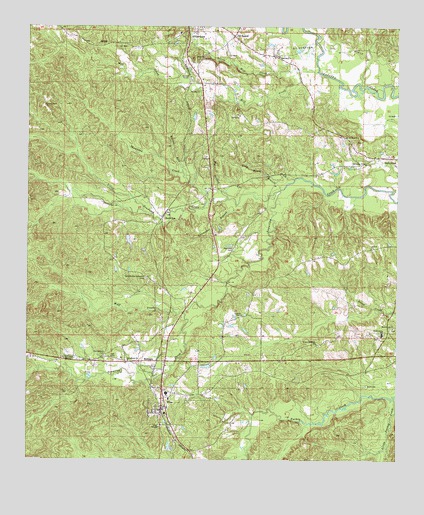
Silas, AL USGS Topographic Map
Click on map above to begin viewing in our Map Viewer.

This topographic map contains these locations and features:
Feature Name Type Latitude Longitude GNIS ID View Map
Allen Temple African Methodist Episcopal Zion ChurchChurchN31.7596°W88.3303°150847View Map
BarrytownPopulated PlaceN31.8374°W88.2528°157885View Map
Barrytown CemeteryCemeteryN31.8426°W88.2658°1805548View Map
Barrytown United Methodist ChurchChurchN31.8360°W88.2617°113519View Map
Beaver RunStreamN31.8329°W88.3231°113750View Map
Big BranchStreamN31.8254°W88.3070°114229View Map
Black Creek Baptist ChurchChurchN31.7885°W88.2511°114421View Map
BolingerPopulated PlaceN31.7785°W88.3311°114696View Map
Branch Church of GodChurchN31.8113°W88.2589°114827View Map
C and J Holiness ChurchChurchN31.7838°W88.2772°115349View Map
Church of GodChurchN31.8435°W88.2675°116131View Map
Coleman BranchStreamN31.7688°W88.2511°139986View Map
Coopers ChapelChurchN31.7918°W88.3028°116591View Map
Coopers Chapel CemeteryCemeteryN31.7918°W88.3028°1805686View Map
Doty House BranchStreamN31.8282°W88.2897°117399View Map
Full Gospel TabernacleChurchN31.7793°W88.3625°118743View Map
Gilbertown CemeteryCemeteryN31.8665°W88.2911°1805514View Map
Gilbertown Church of GodChurchN31.8665°W88.2909°118943View Map
Gilbertown Oil FieldOilfieldN31.8685°W88.2700°118945View Map
Gilbertown Volunteer Fire DepartmentBuildingN31.8724°W88.3160°2691100View Map
Glorious Temple Church of GodChurchN31.8607°W88.3209°119050View Map
Golden Horn BranchStreamN31.8582°W88.2611°140008View Map
Goodwill Assembly of God ChurchChurchN31.8704°W88.3206°140009View Map
Hall CemeteryCemeteryN31.7715°W88.2603°119576View Map
Hardshell Church (historical)ChurchN31.8243°W88.3500°140015View Map
Harrison CemeteryCemeteryN31.8110°W88.3058°119816View Map
Hickory Grove Baptist ChurchChurchN31.8218°W88.3272°140016View Map
Little Mill CreekStreamN31.8629°W88.2845°152103View Map
Little Mill Creek Oil FieldOilfieldN31.8563°W88.3034°151158View Map
Little Souwilpa CreekStreamN31.8282°W88.2897°121894View Map
Little Turkey CreekStreamN31.7677°W88.2508°158004View Map
Mill BranchStreamN31.8710°W88.2711°140055View Map
Mill CreekStreamN31.8621°W88.2775°152326View Map
Mill Creek Oil FieldOilfieldN31.8621°W88.3259°151160View Map
Nix Bridge (historical)BridgeN31.8588°W88.2531°140077View Map
Old SamuelPopulated PlaceN31.8724°W88.3061°124247View Map
Paragon School (historical)SchoolN31.8704°W88.3567°140085View Map
Pine BranchStreamN31.7729°W88.3575°140089View Map
Rocky BranchStreamN31.7607°W88.2797°140111View Map
Seventh -Day Adventist CemeteryCemeteryN31.8024°W88.3353°126566View Map
Shady Grove Baptist ChurchChurchN31.7860°W88.2556°140120View Map
Shady Grove CemeteryCemeteryN31.7860°W88.2564°1805541View Map
Shady Grove High SchoolSchoolN31.7863°W88.2547°126619View Map
Shumaker BranchStreamN31.8238°W88.3047°126824View Map
SilasPopulated PlaceN31.7654°W88.3292°126840View Map
Silas DivisionCivilN31.7617°W88.3023°165698View Map
Silas Elementary SchoolSchoolN31.7677°W88.3270°140124View Map
Silas Police DepartmentBuildingN31.7678°W88.3270°2751785View Map
Silas Post OfficePost OfficeN31.7652°W88.3282°2789072View Map
Silas Volunteer Fire DepartmentBuildingN31.7688°W88.3290°2691125View Map
Smiths CemeteryCemeteryN31.8524°W88.3700°153480View Map
Southern Choctaw High SchoolSchoolN31.7693°W88.3275°140132View Map
Southwest Barrytown Oil FieldOilfieldN31.8377°W88.2875°151164View Map
SouwilpaPopulated PlaceN31.8202°W88.3292°127156View Map
Spring Bank Baptist ChurchChurchN31.7788°W88.3409°153544View Map
Springbank CemeteryCemeteryN31.7799°W88.3489°153543View Map
Taylor Mill (historical)LocaleN31.8238°W88.3056°140140View Map
Thompson CreekStreamN31.8246°W88.3136°127903View Map
Town of SilasCivilN31.7678°W88.3259°2407336View Map
Vanilla School (historical)SchoolN31.8693°W88.3381°140151View Map
West Barrytown Oil FieldOilfieldN31.8568°W88.2772°151167View Map
Wolf CreekStreamN31.7924°W88.3222°129166View Map

Note: Coordinates in the location and feature list above are referenced to NAD83 datum.


Copyright (C) 2008-2024 Ryan Niemi / Sunset Dynamics ... All Rights Reserved