TopoQuest Logo
Do you find TopoQuest useful?
Help keep TopoQuest running and adding new maps/features by donating!
Bitcoin:  19c7KJd3qBynnjoSw5npx9KScwjBe4ifkT
Litecoin:  LXs6TkuXGGXo1vDsWCkWVdjQX94eUKd6ui
Home View Maps Find Maps Find Places Resources & Links


Isney, Alabama Topographic Map

USGS Map Title: Isney, AL
USGS Map MRC: 31088G4
DRG (GeoTIFF) Download: o31088g4.tif


Neighboring USGS Topographic Map Quads:


  Carmichael, MS  
31088H5
 

  Melvin, AL  
31088H4
 

  Toxey, AL  
31088H3
 

  Matherville, MS  
31088G5
 

  Isney, AL  
31088G4
 

  Silas, AL  
31088G3
 

  Denham, MS  
31088F5
 

  Aquilla, AL  
31088F4
 

  Millry North, AL  
31088F3


Map MRC Location:

N32°
W89°
N32°
W88°
H8 H7 H6 H5 H4 H3 H2 H1
G8 G7 G6 G5 G4 G3 G2 G1
F8 F7 F6 F5 F4 F3 F2 F1
E8 E7 E6 E5 E4 E3 E2 E1
D8 D7 D6 D5 D4 D3 D2 D1
C8 C7 C6 C5 C4 C3 C2 C1
B8 B7 B6 B5 B4 B3 B2 B1
A8 A7 A6 A5 A4 A3 A2 A1
N31°
W89°
N31°
W88°

Isney, AL USGS 1:24K Topographic Map Preview:
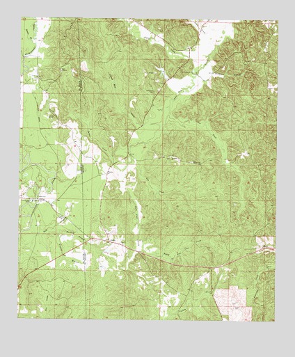
Isney, AL USGS Topographic Map
Click on map above to begin viewing in our Map Viewer.

This topographic map contains these locations and features:
Feature Name Type Latitude Longitude GNIS ID View Map
Burford BranchStreamN31.7868°W88.4814°115220View Map
Carroll School (historical)SchoolN31.8243°W88.3911°139973View Map
Chambers BranchStreamN31.8577°W88.4084°115922View Map
Coyt ChurchChurchN31.8532°W88.4800°668922View Map
EmoryPopulated PlaceN31.8107°W88.4575°156316View Map
Emory (historical)LocaleN31.8524°W88.4384°139994View Map
Frost BridgeBridgeN31.7996°W88.4914°670260View Map
Frost Bridge CampLocaleN31.7990°W88.4939°670261View Map
Gin BranchStreamN31.8632°W88.4209°140007View Map
Gin CreekStreamN31.8165°W88.4456°118984View Map
Gin Creek Baptist ChurchChurchN31.8178°W88.4259°118992View Map
Gin Creek Oil FieldOilfieldN31.7988°W88.4259°151157View Map
IsneyPopulated PlaceN31.7824°W88.4556°120718View Map
Isney Baptist ChurchChurchN31.7815°W88.4495°151868View Map
James CreekStreamN31.8718°W88.4011°120811View Map
John Green DamDamN31.8502°W88.4284°129996View Map
John Green PondReservoirN31.8531°W88.4310°129995View Map
Lamar Mill CreekStreamN31.8310°W88.4317°121352View Map
Lee CreekStreamN31.8352°W88.4281°121469View Map
Loften CemeteryCemeteryN31.7557°W88.3945°121960View Map
Negro CreekStreamN31.8602°W88.4089°123681View Map
Old Bethel CemeteryCemeteryN31.8157°W88.4164°155181View Map
Old Shady Grove CemeteryCemeteryN31.8007°W88.4989°706439View Map
Patton CreekStreamN31.8129°W88.4489°124497View Map
Pine Grove CemeteryCemeteryN31.8449°W88.4356°124774View Map
Prairie BranchStreamN31.7874°W88.4831°125235View Map
Prong Puss Cuss CreekStreamN31.7818°W88.4400°125300View Map
Puss Cuss Creek Oil FieldOilfieldN31.7799°W88.4045°151162View Map
Salem CemeteryCemeteryN31.8007°W88.4906°677261View Map
Sanderson Pond DamDamN31.7985°W88.4850°680897View Map
Sandfield ChurchChurchN31.7924°W88.4800°677365View Map
Silas Oil FieldOilfieldN31.7710°W88.3889°151163View Map
Souwilpa Creek Gas FieldOilfieldN31.7599°W88.4011°151165View Map
Stevens BranchStreamN31.8657°W88.4945°678276View Map
Tabernacle ChurchChurchN31.8657°W88.3809°140136View Map
Wayne County Volunteer Fire Department Coyt StationBuildingN31.8434°W88.4856°2667991View Map
West Point Church (historical)ChurchN31.7552°W88.4439°140157View Map

Note: Coordinates in the location and feature list above are referenced to NAD83 datum.


Copyright (C) 2008-2025 Ryan Niemi / Sunset Dynamics ... All Rights Reserved