TopoQuest Logo
Do you find TopoQuest useful?
Help keep TopoQuest running and adding new maps/features by donating!
Bitcoin:  19c7KJd3qBynnjoSw5npx9KScwjBe4ifkT
Litecoin:  LXs6TkuXGGXo1vDsWCkWVdjQX94eUKd6ui
Home View Maps Find Maps Find Places Resources & Links


Toxey, Alabama Topographic Map

USGS Map Title: Toxey, AL
USGS Map MRC: 31088H3
DRG (GeoTIFF) Download: o31088h3.tif


Neighboring USGS Topographic Map Quads:


  Hinton, AL  
32088A4
 

  Land, AL  
32088A3
 

  Butler, AL  
32088A2
 

  Melvin, AL  
31088H4
 

  Toxey, AL  
31088H3
 

  Ararat, AL  
31088H2
 

  Isney, AL  
31088G4
 

  Silas, AL  
31088G3
 

  Coffeeville Lock And Dam, AL  
31088G2


Map MRC Location:

N32°
W89°
N32°
W88°
H8 H7 H6 H5 H4 H3 H2 H1
G8 G7 G6 G5 G4 G3 G2 G1
F8 F7 F6 F5 F4 F3 F2 F1
E8 E7 E6 E5 E4 E3 E2 E1
D8 D7 D6 D5 D4 D3 D2 D1
C8 C7 C6 C5 C4 C3 C2 C1
B8 B7 B6 B5 B4 B3 B2 B1
A8 A7 A6 A5 A4 A3 A2 A1
N31°
W89°
N31°
W88°

Toxey, AL USGS 1:24K Topographic Map Preview:
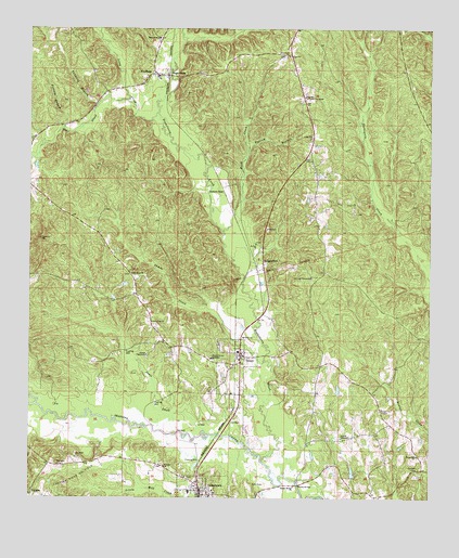
Toxey, AL USGS Topographic Map
Click on map above to begin viewing in our Map Viewer.

This topographic map contains these locations and features:
Feature Name Type Latitude Longitude GNIS ID View Map
Bear CreekStreamN31.9976°W88.3261°139944View Map
Bible Chapel ChurchChurchN31.9993°W88.3636°139950View Map
BogueloosaPopulated PlaceN31.9876°W88.3325°114673View Map
Bogueloosa Baptist ChurchChurchN31.9976°W88.3356°114674View Map
Bogueloosa CemeteryCemeteryN31.9968°W88.3350°1805625View Map
Bogueloosa CreekStreamN31.8849°W88.3020°114675View Map
Bonner Memorial CemeteryCemeteryN31.9124°W88.3384°154714View Map
Bonner TabernacleChurchN31.9129°W88.3386°114725View Map
Boswell TabernacleChurchN31.8913°W88.2775°114753View Map
BrightwaterPopulated PlaceN31.9801°W88.3542°139954View Map
Buck CreekStreamN31.9454°W88.3147°115109View Map
Butterfly BranchStreamN31.9371°W88.2514°139964View Map
Campbell BranchStreamN31.9293°W88.2500°139970View Map
Cane CreekStreamN31.9810°W88.3453°115543View Map
Chapel Hill ChurchChurchN31.8865°W88.2539°115957View Map
Chapel Hill School (historical)SchoolN31.8863°W88.2536°139975View Map
Chappell HillPopulated PlaceN31.8918°W88.2556°139976View Map
Choctaw Ridge Oil FieldOilfieldN31.8813°W88.3611°116084View Map
Dixie BranchStreamN31.9488°W88.2622°139993View Map
GilbertownPopulated PlaceN31.8771°W88.3214°118942View Map
Gilbertown Junior High SchoolSchoolN31.8768°W88.3250°140005View Map
Gilbertown Post OfficePost OfficeN31.8777°W88.3232°2788959View Map
Gilbertown-Toxey DivisionCivilN31.9395°W88.3486°165696View Map
Grace Chapel Assembly of God ChurchChurchN31.8988°W88.2650°119195View Map
HodgewoodPopulated PlaceN31.9374°W88.3022°120179View Map
Jackson SpurPopulated PlaceN31.9568°W88.3150°156520View Map
James CreekStreamN31.9115°W88.3020°120807View Map
Liberty (historical)LocaleN31.9377°W88.3050°140036View Map
Long CreekStreamN31.9774°W88.3359°122006View Map
LuskPopulated PlaceN31.9682°W88.2875°1729813View Map
Lusk Assembly of God ChurchChurchN31.9340°W88.2872°124223View Map
Lusk Baptist ChurchChurchN31.9713°W88.2878°152174View Map
Lusk School (historical)SchoolN31.9938°W88.2975°140043View Map
Lusk Volunteer Fire DepartmentBuildingN31.9295°W88.2870°2691317View Map
Mill BranchStreamN31.8918°W88.3122°140054View Map
Mosley BridgeBridgeN31.8788°W88.2909°123108View Map
Mosley Bridge Congregational Methodist ChurchChurchN31.8785°W88.2922°152389View Map
Mosley CemeteryCemeteryN31.8910°W88.2781°140066View Map
Mosley CemeteryCemeteryN31.9029°W88.2953°154713View Map
NeedhamPopulated PlaceN31.9879°W88.3367°123671View Map
Needham Assembly of God ChurchChurchN31.9874°W88.3353°140075View Map
Needham Volunteer Fire DepartmentBuildingN31.9841°W88.3507°2691325View Map
New Hope Church of GodChurchN31.9221°W88.3370°152634View Map
New Lusk United Methodist ChurchChurchN31.9926°W88.2959°152658View Map
North Choctaw Ridge Oil FieldOilfieldN31.8946°W88.3195°151161View Map
Oak Grove Baptist ChurchChurchN31.9346°W88.3434°152730View Map
Oak Grove CemeteryCemeteryN31.9346°W88.3436°1805515View Map
Old Lusk CemeteryCemeteryN31.9335°W88.2870°140079View Map
ParagonPopulated PlaceN31.8763°W88.3745°156855View Map
Paragon CemeteryCemeteryN31.8838°W88.3661°124428View Map
Paragon Church (historical)ChurchN31.8835°W88.3659°140084View Map
Phillips BranchStreamN31.8977°W88.3689°140088View Map
Possum BranchStreamN31.9682°W88.3078°125191View Map
Possum BranchStreamN31.9732°W88.3647°125192View Map
Puss Cuss CreekStreamN31.8999°W88.3728°153092View Map
Red Crossroads (historical)LocaleN31.9102°W88.2842°140099View Map
Rock BranchStreamN31.9340°W88.3081°140105View Map
Rose Hill School (historical)SchoolN31.9182°W88.2845°140113View Map
Saint Luke ChurchChurchN31.8835°W88.3328°126140View Map
Saint Paul United Methodist ChurchChurchN31.9429°W88.3047°153281View Map
Seals CreekStreamN31.8929°W88.3203°126506View Map
South Choctaw AcademySchoolN31.9124°W88.3184°127116View Map
Stewart CemeteryCemeteryN31.8826°W88.2539°127380View Map
Sugar Ridge Oil FieldOilfieldN31.9015°W88.2820°151166View Map
Tanyard BranchStreamN31.9796°W88.3545°153649View Map
The Church of Latter Day SaintsChurchN31.9821°W88.2897°116145View Map
Town of GilbertownCivilN31.8758°W88.3195°2406569View Map
Town of NeedhamCivilN31.9870°W88.3366°2406970View Map
Town of ToxeyCivilN31.9107°W88.3091°2406745View Map
ToxeyPopulated PlaceN31.9129°W88.3095°128045View Map
Toxey ChurchChurchN31.9179°W88.3086°128046View Map
Toxey Oil FieldOilfieldN31.9546°W88.2778°128047View Map
Toxey Police DepartmentBuildingN31.9130°W88.3088°2752009View Map
Toxey Post OfficePost OfficeN31.9141°W88.3074°2789005View Map
Toxey Volunteer Fire DepartmentBuildingN31.9141°W88.3106°2691326View Map
Tullis School (historical)SchoolN31.9315°W88.3411°140144View Map

Note: Coordinates in the location and feature list above are referenced to NAD83 datum.


Copyright (C) 2008-2024 Ryan Niemi / Sunset Dynamics ... All Rights Reserved