TopoQuest Logo
Do you find TopoQuest useful?
Help keep TopoQuest running and adding new maps/features by donating!
Bitcoin:  19c7KJd3qBynnjoSw5npx9KScwjBe4ifkT
Litecoin:  LXs6TkuXGGXo1vDsWCkWVdjQX94eUKd6ui
Home View Maps Find Maps Find Places Resources & Links


Slater Butte, California Topographic Map

USGS Map Title: Slater Butte, CA
USGS Map MRC: 41123G3
DRG (GeoTIFF) Download: o41123g3.tif


Neighboring USGS Topographic Map Quads:


  Deadman Point, CA  
41123H4
 

  Figurehead Mountain, CA  
41123H3
 

  Kangaroo Mountain, CA  
41123H2
 

  Happy Camp, CA  
41123G4
 

  Slater Butte, CA  
41123G3
 

  Seiad Valley, CA  
41123G2
 

  Clear Creek, CA  
41123F4
 

  Huckleberry Mountain, CA  
41123F3
 

  Grider Valley, CA  
41123F2


Map MRC Location:

N42°
W124°
N42°
W123°
H8 H7 H6 H5 H4 H3 H2 H1
G8 G7 G6 G5 G4 G3 G2 G1
F8 F7 F6 F5 F4 F3 F2 F1
E8 E7 E6 E5 E4 E3 E2 E1
D8 D7 D6 D5 D4 D3 D2 D1
C8 C7 C6 C5 C4 C3 C2 C1
B8 B7 B6 B5 B4 B3 B2 B1
A8 A7 A6 A5 A4 A3 A2 A1
N41°
W124°
N41°
W123°

Slater Butte, CA USGS 1:24K Topographic Map Preview:
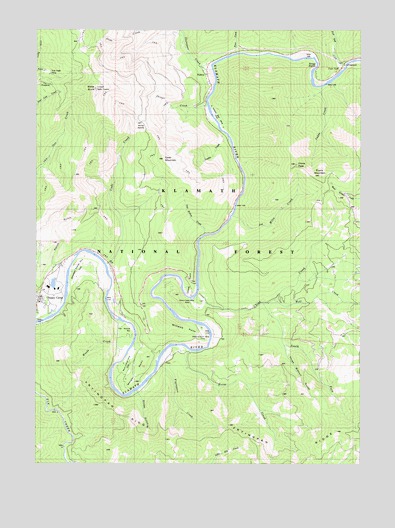
Slater Butte, CA USGS Topographic Map
Click on map above to begin viewing in our Map Viewer.

This topographic map contains these locations and features:
Feature Name Type Latitude Longitude GNIS ID View Map
Bonetta Bee MineMineN41.8532°W123.3101°1652943View Map
Cade CreekStreamN41.8071°W123.3492°220361View Map
Cade MountainSummitN41.8373°W123.3278°220362View Map
China CreekStreamN41.7990°W123.3137°221022View Map
China Creek MineMineN41.7973°W123.3148°221025View Map
China PeakSummitN41.8360°W123.2762°221052View Map
China PointCapeN41.8007°W123.3176°221054View Map
Evans MountainSummitN41.8326°W123.2667°276451View Map
Fort GoffPopulated PlaceN41.8621°W123.2567°1658565View Map
Fort Goff CampgroundLocaleN41.8651°W123.2576°276449View Map
Fort Goff CreekStreamN41.8635°W123.2576°223697View Map
Fryingpan CreekStreamN41.7779°W123.3289°223979View Map
Fryingpan RidgeRidgeN41.7560°W123.3131°223980View Map
Gordons Ferry (historical)CrossingN41.7812°W123.3276°1682350View Map
Grey Eagle MineMineN41.8626°W123.3739°224606View Map
Horse CreekStreamN41.7837°W123.3201°225601View Map
Joe Miles CreekStreamN41.8212°W123.3001°226253View Map
Karuk ReservationCivilN41.8058°W123.3565°2418982View Map
Ladds CreekStreamN41.8585°W123.2659°226741View Map
Morgan PointCapeN41.7751°W123.3376°229053View Map
Muck a Muck MineMineN41.7723°W123.3437°229221View Map
NoltonLocaleN41.8626°W123.3106°229571View Map
Nolton School (historical)SchoolN41.8690°W123.2881°1682355View Map
Oak Hollow CreekStreamN41.8151°W123.3123°229860View Map
Ottley GulchValleyN41.7698°W123.3364°230148View Map
Ranch GulchValleyN41.8073°W123.3703°231208View Map
Reeves MineMineN41.7818°W123.3398°231474View Map
Reeves RanchLocaleN41.8065°W123.3681°1682356View Map
Richardson Bedrock MineMineN41.8098°W123.3578°231545View Map
Savage RapidsRapidsN41.8637°W123.2692°276450View Map
Seattle CreekStreamN41.8432°W123.3017°232768View Map
Shinar CreekStreamN41.8533°W123.3103°1652942View Map
Shinar SaddleGapN41.8471°W123.3339°252198View Map
Slater ButteSummitN41.8582°W123.3548°233251View Map
South Fork China CreekStreamN41.7957°W123.2887°234985View Map
Thompson CreekStreamN41.8636°W123.3083°255138View Map
Three Biscuit GulchValleyN41.7826°W123.2798°236304View Map
Tims CreekStreamN41.8679°W123.2995°236371View Map
Williams PointCapeN41.7854°W123.3137°237852View Map
Williams Point MineMineN41.7848°W123.3134°276446View Map
Wolf CreekStreamN41.7965°W123.2842°238088View Map
Woods BarBarN41.7876°W123.3389°238153View Map
Woods CreekStreamN41.7817°W123.3411°255244View Map

Note: Coordinates in the location and feature list above are referenced to NAD83 datum.


Copyright (C) 2008-2024 Ryan Niemi / Sunset Dynamics ... All Rights Reserved