TopoQuest Logo
Do you find TopoQuest useful?
Help keep TopoQuest running and adding new maps/features by donating!
Bitcoin:  19c7KJd3qBynnjoSw5npx9KScwjBe4ifkT
Litecoin:  LXs6TkuXGGXo1vDsWCkWVdjQX94eUKd6ui
Home View Maps Find Maps Find Places Resources & Links


Smallett, Missouri Topographic Map

USGS Map Title: Smallett, MO
USGS Map MRC: 36092G6
DRG (GeoTIFF) Download: o36092g6.tif


Neighboring USGS Topographic Map Quads:


  Goodhope, MO  
36092H7
 

  Ava, MO  
36092H6
 

  Sweden, MO  
36092H5
 

  Brownbranch, MO  
36092G7
 

  Smallett, MO  
36092G6
 

  Wasola, MO  
36092G5
 

  Protem NE, MO  
36092F7
 

  Thornfield, MO  
36092F6
 

  Willhoit, MO  
36092F5


Map MRC Location:

N37°
W93°
N37°
W92°
H8 H7 H6 H5 H4 H3 H2 H1
G8 G7 G6 G5 G4 G3 G2 G1
F8 F7 F6 F5 F4 F3 F2 F1
E8 E7 E6 E5 E4 E3 E2 E1
D8 D7 D6 D5 D4 D3 D2 D1
C8 C7 C6 C5 C4 C3 C2 C1
B8 B7 B6 B5 B4 B3 B2 B1
A8 A7 A6 A5 A4 A3 A2 A1
N36°
W93°
N36°
W92°

Smallett, MO USGS 1:24K Topographic Map Preview:
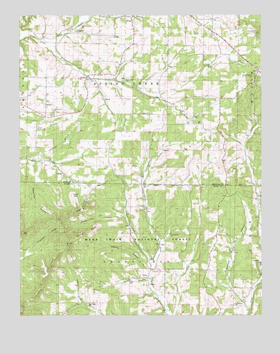
Smallett, MO USGS Topographic Map
Click on map above to begin viewing in our Map Viewer.

This topographic map contains these locations and features:
Feature Name Type Latitude Longitude GNIS ID View Map
Bethlehem Church (historical)ChurchN36.7948°W92.6341°748808View Map
Brissel RidgeRidgeN36.7701°W92.7221°714720View Map
Bristle RidgeRidgeN36.7964°W92.7157°738474View Map
Buzzard Roost HollowValleyN36.7520°W92.6310°753589View Map
Carpenter BranchStreamN36.8145°W92.7402°753598View Map
Caudle RidgeRidgeN36.7851°W92.7168°753594View Map
Clark CemeteryCemeteryN36.7726°W92.6265°754039View Map
Clark School (historical)SchoolN36.7826°W92.6271°749371View Map
Coon Knob HillSummitN36.8689°W92.6254°753601View Map
East Prong Little CreekStreamN36.7714°W92.6282°749786View Map
FoilPopulated PlaceN36.7562°W92.6354°749953View Map
Frye CemeteryCemeteryN36.8292°W92.6565°750694View Map
Frye ChurchChurchN36.8303°W92.6641°750005View Map
Haden BaldSummitN36.8001°W92.7227°753597View Map
Holt CemeteryCemeteryN36.8584°W92.6474°753600View Map
Krider BranchStreamN36.7659°W92.6841°750638View Map
Krider CemeteryCemeteryN36.7639°W92.6938°753591View Map
Little Creek School (historical)SchoolN36.7976°W92.6349°733791View Map
Maloney HollowValleyN36.7678°W92.6818°753593View Map
Middle Prong Little CreekStreamN36.7812°W92.6266°751044View Map
New Harmony ChurchChurchN36.7837°W92.6721°753590View Map
Norris-Piland CemeteryCemeteryN36.7548°W92.6402°754130View Map
North Spring CreekStreamN36.8617°W92.7349°751359View Map
Otter Creek CemeteryCemeteryN36.7542°W92.7149°753592View Map
Otter Creek School (historical)SchoolN36.7553°W92.7166°751456View Map
Prieskon RidgeRidgeN36.7826°W92.7366°753596View Map
Robinson SchoolSchoolN36.8703°W92.6643°751917View Map
Salt Road Post OfficePost OfficeN36.8487°W92.7141°765613View Map
Silver Shade ChurchChurchN36.8731°W92.7013°752163View Map
Silver Shade School (historical)SchoolN36.8662°W92.7113°752164View Map
SmallettPopulated PlaceN36.8487°W92.7141°758446View Map
South Spring CreekStreamN36.8617°W92.7349°752272View Map
Spring CreekStreamN36.8648°W92.7499°752300View Map
Spring Creek ChurchChurchN36.8483°W92.6950°726910View Map
Squires Post OfficePost OfficeN36.8521°W92.6266°2782747View Map
Squires Volunteer Fire DepartmentBuildingN36.8502°W92.6271°2621676View Map
Sugar Tree HollowValleyN36.7878°W92.6938°753595View Map
Surgoine BranchStreamN36.8748°W92.7132°752436View Map
ToledoPopulated PlaceN36.7745°W92.6854°752553View Map
Township of Spring CreekCivilN36.8485°W92.6915°766631View Map
Tranquility School (historical)SchoolN36.7739°W92.6829°733792View Map
Walnut Grove ChurchChurchN36.8359°W92.7329°752740View Map
Walnut Grove School (historical)SchoolN36.8326°W92.7193°752743View Map

Note: Coordinates in the location and feature list above are referenced to NAD83 datum.


Copyright (C) 2008-2025 Ryan Niemi / Sunset Dynamics ... All Rights Reserved