TopoQuest Logo
Do you find TopoQuest useful?
Help keep TopoQuest running and adding new maps/features by donating!
Bitcoin:  19c7KJd3qBynnjoSw5npx9KScwjBe4ifkT
Litecoin:  LXs6TkuXGGXo1vDsWCkWVdjQX94eUKd6ui
Home View Maps Find Maps Find Places Resources & Links


Smartville, California Topographic Map

USGS Map Title: Smartville, CA
USGS Map MRC: 39121B3
DRG (GeoTIFF) Download: o39121b3.tif


Neighboring USGS Topographic Map Quads:


  Loma Rica, CA  
39121C4
 

  Oregon House, CA  
39121C3
 

  French Corral, CA  
39121C2
 

  Browns Valley, CA  
39121B4
 

  Smartville, CA  
39121B3
 

  Rough And Ready, CA  
39121B2
 

  Wheatland, CA  
39121A4
 

  Camp Far West, CA  
39121A3
 

  Wolf, CA  
39121A2


Map MRC Location:

N40°
W122°
N40°
W121°
H8 H7 H6 H5 H4 H3 H2 H1
G8 G7 G6 G5 G4 G3 G2 G1
F8 F7 F6 F5 F4 F3 F2 F1
E8 E7 E6 E5 E4 E3 E2 E1
D8 D7 D6 D5 D4 D3 D2 D1
C8 C7 C6 C5 C4 C3 C2 C1
B8 B7 B6 B5 B4 B3 B2 B1
A8 A7 A6 A5 A4 A3 A2 A1
N39°
W122°
N39°
W121°

Smartville, CA USGS 1:24K Topographic Map Preview:
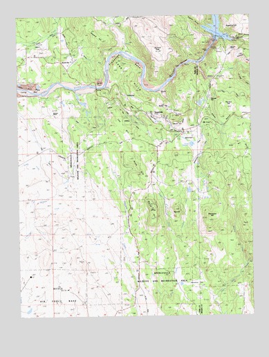
Smartville, CA USGS Topographic Map
Click on map above to begin viewing in our Map Viewer.

This topographic map contains these locations and features:
Feature Name Type Latitude Longitude GNIS ID View Map
Allenwood HillSummitN39.1643°W121.2741°218148View Map
Big Oak ValleyPopulated PlaceN39.1917°W121.2561°2363569View Map
Big RavineValleyN39.2216°W121.3233°219233View Map
Blue Point MineMineN39.2091°W121.2902°219510View Map
Bonanza RanchLocaleN39.2085°W121.3566°219627View Map
Brady Ranch (historical)LocaleN39.1957°W121.3586°1703468View Map
Brooks CreekStreamN39.2191°W121.3461°219875View Map
Buzzard PeakSummitN39.2346°W121.3019°220317View Map
China DitchCanalN39.2177°W121.2633°233667View Map
Daugherty CreekStreamN39.1557°W121.2944°222033View Map
Deer CreekStreamN39.2296°W121.2802°222178View Map
Dempsey CreekStreamN39.1554°W121.2944°222259View Map
Empire RanchLocaleN39.2002°W121.2900°223202View Map
Farm DitchCanalN39.2046°W121.3427°223398View Map
Forbes RanchLocaleN39.2416°W121.3200°223664View Map
Frisky DamDamN39.1782°W121.3611°1664553View Map
Frisky LakeReservoirN39.1782°W121.3611°1664554View Map
Hackett CreekStreamN39.1460°W121.2558°224764View Map
Harry L Englebright Lake DamDamN39.2400°W121.2697°1664529View Map
Harry L. Englebright LakeReservoirN39.2439°W121.2687°233986View Map
Hill CrestLocaleN39.2041°W121.2794°225317View Map
Hogback RavineValleyN39.2454°W121.2783°243523View Map
Horseshoe FlatFlatN39.1374°W121.2819°225644View Map
Howard HillSummitN39.2427°W121.3350°1658787View Map
Joe Miller RavineValleyN39.2396°W121.2600°226254View Map
Keystone RanchLocaleN39.2366°W121.2619°226564View Map
Lee HillRidgeN39.2041°W121.3211°226992View Map
Lone TreeParkN39.1452°W121.3400°227520View Map
Long BarBarN39.2185°W121.3700°227536View Map
Meade HillSummitN39.2054°W121.2908°1659094View Map
Mooney FlatPopulated PlaceN39.2154°W121.2744°1659169View Map
Ousley DitchCanalN39.2077°W121.3180°230161View Map
Parks Bar (historical)LocaleN39.2210°W121.3313°1703573View Map
Peardon HillSummitN39.2127°W121.2638°1659359View Map
Ray HillSummitN39.1691°W121.2922°231290View Map
Riffle Box RavineValleyN39.2032°W121.2677°231575View Map
Rose BarLocaleN39.2191°W121.2997°231881View Map
Rose Bar SchoolSchoolN39.2093°W121.3041°1703513View Map
Rose HillSummitN39.1899°W121.3125°231886View Map
Sand HillsRangeN39.2229°W121.3172°232503View Map
Sanford CreekStreamN39.2110°W121.3161°232528View Map
Sicard FlatPopulated PlaceN39.2310°W121.3461°1659659View Map
Sicard Flat DitchCanalN39.2352°W121.3305°233075View Map
Slacks RavineValleyN39.2235°W121.2744°233230View Map
SmartsvillePopulated PlaceN39.2074°W121.2986°1659684View Map
Smartsville Catholic CemeteryCemeteryN39.2021°W121.2988°1703515View Map
Smartsville Census Designated PlaceCensusN39.2053°W121.2929°2628789View Map
Smartsville Fire Protection DistrictBuildingN39.2070°W121.2959°2621988View Map
Smartsville Post OfficePost OfficeN39.2062°W121.2966°2769555View Map
Smith Bar DitchCanalN39.2424°W121.3561°233367View Map
Sucker FlatPopulated PlaceN39.2118°W121.2972°1659891View Map
Sugarloaf HillSummitN39.2446°W121.2602°1659905View Map
The NarrowsChannelN39.2296°W121.2880°236198View Map
TimbuctooPopulated PlaceN39.2168°W121.3186°1660003View Map
Timbuctoo BendBendN39.2321°W121.3183°236368View Map
Timbuctoo CemeteryCemeteryN39.2160°W121.3175°2773293View Map
Toland Ranch (historical)LocaleN39.1896°W121.3255°1703519View Map
Union ReservoirReservoirN39.1965°W121.2829°236837View Map
Walsh HillSummitN39.1699°W121.3047°237209View Map
Wellman CreekStreamN39.1624°W121.3705°237411View Map

Note: Coordinates in the location and feature list above are referenced to NAD83 datum.


Copyright (C) 2008-2025 Ryan Niemi / Sunset Dynamics ... All Rights Reserved