TopoQuest Logo
Do you find TopoQuest useful?
Help keep TopoQuest running and adding new maps/features by donating!
Bitcoin:  19c7KJd3qBynnjoSw5npx9KScwjBe4ifkT
Litecoin:  LXs6TkuXGGXo1vDsWCkWVdjQX94eUKd6ui
Home View Maps Find Maps Find Places Resources & Links


Rough And Ready, California Topographic Map

USGS Map Title: Rough And Ready, CA
USGS Map MRC: 39121B2
DRG (GeoTIFF) Download: o39121b2.tif


Neighboring USGS Topographic Map Quads:


  Oregon House, CA  
39121C3
 

  French Corral, CA  
39121C2
 

  Nevada City, CA  
39121C1
 

  Smartville, CA  
39121B3
 

  Rough And Ready, CA  
39121B2
 

  Grass Valley, CA  
39121B1
 

  Camp Far West, CA  
39121A3
 

  Wolf, CA  
39121A2
 

  Lake Combie, CA  
39121A1


Map MRC Location:

N40°
W122°
N40°
W121°
H8 H7 H6 H5 H4 H3 H2 H1
G8 G7 G6 G5 G4 G3 G2 G1
F8 F7 F6 F5 F4 F3 F2 F1
E8 E7 E6 E5 E4 E3 E2 E1
D8 D7 D6 D5 D4 D3 D2 D1
C8 C7 C6 C5 C4 C3 C2 C1
B8 B7 B6 B5 B4 B3 B2 B1
A8 A7 A6 A5 A4 A3 A2 A1
N39°
W122°
N39°
W121°

Rough And Ready, CA USGS 1:24K Topographic Map Preview:
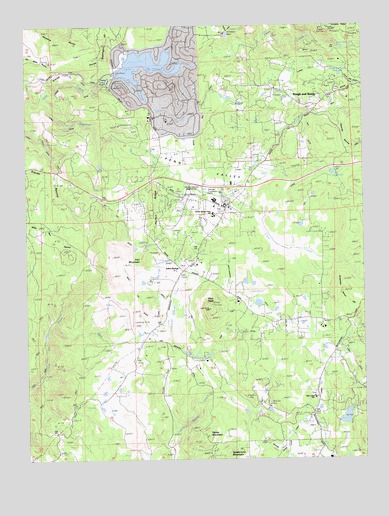
Rough And Ready, CA USGS Topographic Map
Click on map above to begin viewing in our Map Viewer.

This topographic map contains these locations and features:
Feature Name Type Latitude Longitude GNIS ID View Map
Anthony House 1300-002 DamDamN39.2349°W121.2211°1664292View Map
Bald Hill DitchCanalN39.1796°W121.2072°218575View Map
Black Bear MineMineN39.2443°W121.1497°219339View Map
Blue RavineValleyN39.2246°W121.1391°233522View Map
Bugler Cove ParkParkN39.2391°W121.2150°1682851View Map
Casey CornerPopulated PlaceN39.1971°W121.1780°1658231View Map
Clear CreekStreamN39.2010°W121.1775°221190View Map
Clear Creek Elementary SchoolSchoolN39.1425°W121.1445°221194View Map
Clear Creek LateralCanalN39.1341°W121.1522°233688View Map
Forest Circle ParkParkN39.2379°W121.1969°1682890View Map
George Washington HillSummitN39.2454°W121.2227°1658605View Map
Grub CreekStreamN39.2082°W121.1675°224684View Map
Haney MountainSummitN39.1310°W121.1847°224871View Map
Horton RidgeRidgeN39.1979°W121.2052°225659View Map
Indian SpringsLocaleN39.1793°W121.1938°225907View Map
Iron MountainSummitN39.1818°W121.2083°1658836View Map
Kentucky RidgeRidgeN39.2496°W121.1355°226525View Map
Kentucky Ridge MineMineN39.2485°W121.1333°226526View Map
Lake WildwoodPopulated PlaceN39.2329°W121.2005°1682906View Map
Lake WildwoodReservoirN39.2349°W121.2211°1664293View Map
Lake Wildwood Census Designated PlaceCensusN39.2350°W121.2003°2408555View Map
Limberlost Ranch AirportAirportN39.2211°W121.2164°1653901View Map
Lower DitchCanalN39.2266°W121.1263°227765View Map
Meadow ParkParkN39.2432°W121.1975°1682920View Map
Miners Gulch ParkParkN39.2341°W121.2086°1682922View Map
Mistletoe MineMineN39.2299°W121.1555°228861View Map
Negro CreekStreamN39.2373°W121.2131°2681563View Map
Niagara MineMineN39.2460°W121.1286°229528View Map
Osceola RavineValleyN39.2241°W121.1377°230135View Map
Peacock PointCapeN39.2388°W121.2013°1682940View Map
Penn ValleyBasinN39.2032°W121.1852°230488View Map
Penn ValleyPopulated PlaceN39.1960°W121.1911°1867050View Map
Penn Valley Census Designated PlaceCensusN39.1953°W121.1942°2409052View Map
Penn Valley Fire Protection District Station 43BuildingN39.1962°W121.1771°2622184View Map
Penn Valley Fire Protection District Station 44BuildingN39.2232°W121.2033°2622183View Map
Penn Valley Post OfficePost OfficeN39.1984°W121.1795°2769476View Map
Pet Hill DitchCanalN39.1913°W121.2150°230554View Map
Pilot PeakSummitN39.1682°W121.1838°230664View Map
Pine Island BeachBeachN39.2332°W121.2127°1682941View Map
Ready Springs Elementary SchoolSchoolN39.1954°W121.1816°1682951View Map
Rex DitchCanalN39.2046°W121.1497°231507View Map
Rex ReservoirReservoirN39.2074°W121.1374°231508View Map
Riffle Box DitchCanalN39.2140°W121.1896°231574View Map
Rough and ReadyPopulated PlaceN39.2302°W121.1361°1659550View Map
Rough and Ready CemeteryCemeteryN39.2316°W121.1355°1682956View Map
Rough and Ready Census Designated PlaceCensusN39.2340°W121.1380°2628785View Map
Rough and Ready Fire StationBuildingN39.2297°W121.1385°2622167View Map
Rough and Ready Grange HallBuildingN39.2296°W121.1394°1682957View Map
Rough and Ready Post OfficePost OfficeN39.2296°W121.1379°2769477View Map
Rough and Ready ReservoirReservoirN39.2356°W121.1343°231921View Map
Smith-Gordon DitchCanalN39.1691°W121.1633°234727View Map
Squirrel CreekStreamN39.2291°W121.2452°235335View Map
Swan 1301 DamDamN39.1349°W121.1344°1664294View Map
Tarr DitchCanalN39.1616°W121.1688°236031View Map
Tunnel DitchCanalN39.2396°W121.1488°236629View Map
Vandervere MountainSummitN39.1271°W121.1772°237027View Map
Vista ParkParkN39.2366°W121.2102°1682989View Map
Western Gateway Regional ParkParkN39.2029°W121.1955°1682995View Map

Note: Coordinates in the location and feature list above are referenced to NAD83 datum.


Copyright (C) 2008-2024 Ryan Niemi / Sunset Dynamics ... All Rights Reserved