TopoQuest Logo
Do you find TopoQuest useful?
Help keep TopoQuest running and adding new maps/features by donating!
Bitcoin:  19c7KJd3qBynnjoSw5npx9KScwjBe4ifkT
Litecoin:  LXs6TkuXGGXo1vDsWCkWVdjQX94eUKd6ui
Home View Maps Find Maps Find Places Resources & Links


Camp Far West, California Topographic Map

USGS Map Title: Camp Far West, CA
USGS Map MRC: 39121A3
DRG (GeoTIFF) Download: o39121a3.tif


Neighboring USGS Topographic Map Quads:


  Browns Valley, CA  
39121B4
 

  Smartville, CA  
39121B3
 

  Rough And Ready, CA  
39121B2
 

  Wheatland, CA  
39121A4
 

  Camp Far West, CA  
39121A3
 

  Wolf, CA  
39121A2
 

  Sheridan, CA  
38121H4
 

  Lincoln, CA  
38121H3
 

  Gold Hill, CA  
38121H2


Map MRC Location:

N40°
W122°
N40°
W121°
H8 H7 H6 H5 H4 H3 H2 H1
G8 G7 G6 G5 G4 G3 G2 G1
F8 F7 F6 F5 F4 F3 F2 F1
E8 E7 E6 E5 E4 E3 E2 E1
D8 D7 D6 D5 D4 D3 D2 D1
C8 C7 C6 C5 C4 C3 C2 C1
B8 B7 B6 B5 B4 B3 B2 B1
A8 A7 A6 A5 A4 A3 A2 A1
N39°
W122°
N39°
W121°

Camp Far West, CA USGS 1:24K Topographic Map Preview:
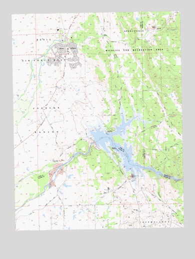
Camp Far West, CA USGS Topographic Map
Click on map above to begin viewing in our Map Viewer.

This topographic map contains these locations and features:
Feature Name Type Latitude Longitude GNIS ID View Map
Albion RavineValleyN39.1110°W121.3108°218077View Map
Auburn RancheriaCivilN39.0229°W121.3244°218454View Map
Austin RavineValleyN39.0632°W121.2625°218471View Map
Beale Air Force Base Census Designated PlaceCensusN39.1096°W121.3542°2407813View Map
Beale Air Force Base Fire Department Station 2BuildingN39.1009°W121.3395°2622232View Map
Beale DamDamN39.1085°W121.3385°1664549View Map
Beale LakeReservoirN39.1089°W121.3376°1664550View Map
Cabbage PatchAreaN39.1124°W121.3069°1703535View Map
Cabbage Patch CemeteryCemeteryN39.1126°W121.3254°2773290View Map
Camp Far West 52-000 DamDamN39.0499°W121.3161°1663459View Map
Camp Far West CemeteryCemeteryN39.0396°W121.3431°2773291View Map
Camp Far West DitchCanalN39.0102°W121.2761°220453View Map
Camp Far West Diversion 52-002 DamDamN39.0420°W121.3321°1664403View Map
Camp Far West Historic SiteLocaleN39.0393°W121.3436°220452View Map
Camp Far West RanchLocaleN39.0266°W121.3411°220454View Map
Camp Far West ReservoirReservoirN39.0316°W121.2866°220455View Map
Cox CreekStreamN39.1121°W121.3075°221722View Map
Dairy Farm MineMineN39.0307°W121.2891°221974View Map
Far West Elementary SchoolSchoolN39.1041°W121.3344°1703546View Map
Fenton RavineValleyN39.0313°W121.2702°223446View Map
Little Dry CreekStreamN39.1143°W121.2702°227251View Map
Lofton CemeteryCemeteryN39.0782°W121.3708°227465View Map
Lone Tree Elementary SchoolSchoolN39.1024°W121.3344°1703559View Map
Long RavineValleyN39.0599°W121.2950°227594View Map
McCourtney Crossing (historical)CrossingN39.0435°W121.2930°1703565View Map
McCourtney Crossing (historical)BridgeN39.0435°W121.2930°1701173View Map
Placer County Fire Department Station 74 ThermalandsBuildingN39.0225°W121.2821°2621881View Map
Rock CreekStreamN39.0616°W121.2797°231711View Map
SpencevilleLocaleN39.1146°W121.2694°235187View Map
ThermalandsAreaN39.0066°W121.2738°236231View Map
Valley View SchoolSchoolN39.0099°W121.2850°236985View Map
Vineyard CreekStreamN39.1118°W121.3100°237097View Map
Waldo JunctionPopulated PlaceN39.1110°W121.3091°1660115View Map
Wheatland Fire Department Station 2BuildingN39.0614°W121.3563°2621916View Map

Note: Coordinates in the location and feature list above are referenced to NAD83 datum.


Copyright (C) 2008-2025 Ryan Niemi / Sunset Dynamics ... All Rights Reserved