TopoQuest Logo
Do you find TopoQuest useful?
Help keep TopoQuest running and adding new maps/features by donating!
Bitcoin:  19c7KJd3qBynnjoSw5npx9KScwjBe4ifkT
Litecoin:  LXs6TkuXGGXo1vDsWCkWVdjQX94eUKd6ui
Home View Maps Find Maps Find Places Resources & Links


Wolf, California Topographic Map

USGS Map Title: Wolf, CA
USGS Map MRC: 39121A2
DRG (GeoTIFF) Download: o39121a2.tif


Neighboring USGS Topographic Map Quads:


  Smartville, CA  
39121B3
 

  Rough And Ready, CA  
39121B2
 

  Grass Valley, CA  
39121B1
 

  Camp Far West, CA  
39121A3
 

  Wolf, CA  
39121A2
 

  Lake Combie, CA  
39121A1
 

  Lincoln, CA  
38121H3
 

  Gold Hill, CA  
38121H2
 

  Auburn, CA  
38121H1


Map MRC Location:

N40°
W122°
N40°
W121°
H8 H7 H6 H5 H4 H3 H2 H1
G8 G7 G6 G5 G4 G3 G2 G1
F8 F7 F6 F5 F4 F3 F2 F1
E8 E7 E6 E5 E4 E3 E2 E1
D8 D7 D6 D5 D4 D3 D2 D1
C8 C7 C6 C5 C4 C3 C2 C1
B8 B7 B6 B5 B4 B3 B2 B1
A8 A7 A6 A5 A4 A3 A2 A1
N39°
W122°
N39°
W121°

Wolf, CA USGS 1:24K Topographic Map Preview:
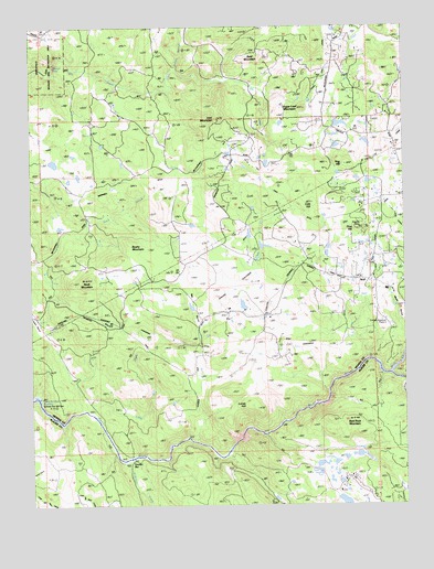
Wolf, CA USGS Topographic Map
Click on map above to begin viewing in our Map Viewer.

This topographic map contains these locations and features:
Feature Name Type Latitude Longitude GNIS ID View Map
Alderman CreekStreamN39.0118°W121.2188°218109View Map
Austin FlatFlatN39.0474°W121.2486°218469View Map
Bald MountainSummitN39.1182°W121.1777°1657979View Map
Bald Rock MountainSummitN39.0221°W121.1436°218612View Map
Banner GrangeLocaleN39.0988°W121.1525°218647View Map
Bushy MountainSummitN39.0688°W121.2188°1658182View Map
Cole DitchCanalN39.0780°W121.1644°221352View Map
Cole HillSummitN39.0788°W121.1572°221354View Map
Cranston RanchLocaleN39.0066°W121.1494°221804View Map
Garden BarLocaleN39.0107°W121.2172°224041View Map
Hog HillSummitN39.0888°W121.1455°225396View Map
Indian Springs CreekStreamN39.1138°W121.2047°225912View Map
Iron MountainSummitN39.1010°W121.1891°225987View Map
Little Wolf CreekStreamN39.0249°W121.2330°227410View Map
Lucas HillSummitN39.0257°W121.1780°227810View Map
Pine HillSummitN39.0718°W121.1413°230699View Map
Pine Hill MineMineN39.0727°W121.1402°230701View Map
Rab RavineValleyN39.0463°W121.1958°231151View Map
Redinger DitchCanalN39.0682°W121.1830°231403View Map
Rock MountainSummitN39.0591°W121.2327°231740View Map
Sugar Loaf MountainSummitN39.1035°W121.1600°235634View Map
Sweet Ranch (historical)LocaleN39.0649°W121.1363°1703635View Map
WolfPopulated PlaceN39.0585°W121.1383°252838View Map
Wolf CreekStreamN39.0343°W121.1308°238087View Map
Wolf DitchCanalN39.0485°W121.1469°238093View Map

Note: Coordinates in the location and feature list above are referenced to NAD83 datum.


Copyright (C) 2008-2024 Ryan Niemi / Sunset Dynamics ... All Rights Reserved