TopoQuest Logo
Do you find TopoQuest useful?
Help keep TopoQuest running and adding new maps/features by donating!
Bitcoin:  19c7KJd3qBynnjoSw5npx9KScwjBe4ifkT
Litecoin:  LXs6TkuXGGXo1vDsWCkWVdjQX94eUKd6ui
Home View Maps Find Maps Find Places Resources & Links


Soperton North, Georgia Topographic Map

USGS Map Title: Soperton North, GA
USGS Map MRC: 32082D5
DRG (GeoTIFF) Download: o32082d5.tif


Neighboring USGS Topographic Map Quads:


  Scott, GA  
32082E6
 

  Adrian, GA  
32082E5
 

  Norristown, GA  
32082E4
 

  Rockledge, GA  
32082D6
 

  Soperton North, GA  
32082D5
 

  Covena, GA  
32082D4
 

  Lothair, GA  
32082C6
 

  Soperton South, GA  
32082C5
 

  Oak Park SW, GA  
32082C4


Map MRC Location:

N33°
W83°
N33°
W82°
H8 H7 H6 H5 H4 H3 H2 H1
G8 G7 G6 G5 G4 G3 G2 G1
F8 F7 F6 F5 F4 F3 F2 F1
E8 E7 E6 E5 E4 E3 E2 E1
D8 D7 D6 D5 D4 D3 D2 D1
C8 C7 C6 C5 C4 C3 C2 C1
B8 B7 B6 B5 B4 B3 B2 B1
A8 A7 A6 A5 A4 A3 A2 A1
N32°
W83°
N32°
W82°

Soperton North, GA USGS 1:24K Topographic Map Preview:
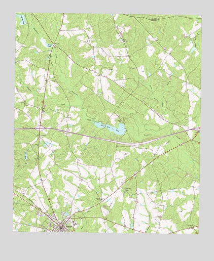
Soperton North, GA USGS Topographic Map
Click on map above to begin viewing in our Map Viewer.

This topographic map contains these locations and features:
Feature Name Type Latitude Longitude GNIS ID View Map
Alligator CreekStreamN32.4477°W82.5799°310483View Map
Anderson PondReservoirN32.4962°W82.6207°310532View Map
Anderson Pond DamDamN32.4932°W82.6185°336133View Map
BlackvillePopulated PlaceN32.4821°W82.5982°331180View Map
Blackville ChurchChurchN32.4843°W82.5976°342633View Map
Camp BranchStreamN32.4360°W82.5207°312196View Map
City of SopertonCivilN32.3782°W82.5944°2405486View Map
Corsey Grove ChurchChurchN32.3999°W82.5496°355327View Map
Exit 18CrossingN32.4341°W82.6076°1705072View Map
Exit 19CrossingN32.4349°W82.5007°1705073View Map
Foursquare ChurchChurchN32.3788°W82.5049°314320View Map
Fowler PondReservoirN32.4185°W82.6167°341160View Map
Fowlers Pond DamDamN32.4185°W82.6165°341159View Map
Gillis CemeteryCemeteryN32.4410°W82.5093°347496View Map
Gillis PondReservoirN32.3942°W82.5604°347498View Map
Gillis Springs DivisionCivilN32.4425°W82.5143°1936285View Map
Harmony ChurchChurchN32.3938°W82.5654°315143View Map
Hebron ChurchChurchN32.4243°W82.6082°315296View Map
Herman PondLakeN32.4816°W82.6029°356268View Map
Hooks CemeteryCemeteryN32.4199°W82.5510°315626View Map
Hutchinson CemeteryCemeteryN32.4310°W82.5257°342637View Map
Jennings Turf FarmLocaleN32.4647°W82.5614°2674804View Map
Johnson ChapelChurchN32.4841°W82.5504°316158View Map
Jordan Hill ChurchChurchN32.4299°W82.6065°316276View Map
Midway ChurchChurchN32.4404°W82.5890°318117View Map
Mount Zion ChurchChurchN32.3757°W82.5957°318975View Map
New Life Fellowship ChurchChurchN32.4005°W82.5821°342641View Map
Oak ChapelChurchN32.4488°W82.6185°319735View Map
Red Ricks LakeReservoirN32.3853°W82.5887°341162View Map
Red Ricks Lake DamDamN32.3852°W82.5899°341161View Map
Ricks CemeteryCemeteryN32.4810°W82.5974°321589View Map
Rock Hill ChurchChurchN32.4646°W82.5668°321732View Map
Saint Marys ChurchChurchN32.4691°W82.5437°322199View Map
Sand Hill LakeReservoirN32.4345°W82.5555°322430View Map
Sand Hill Lake DamDamN32.4346°W82.5593°341489View Map
Sherrod PondReservoirN32.3884°W82.5811°347502View Map
Shiloh CemeteryCemeteryN32.4391°W82.5521°322853View Map
SopertonPopulated PlaceN32.3771°W82.5924°323223View Map
Soperton City HallBuildingN32.3796°W82.5924°342643View Map
Soperton Police DepartmentBuildingN32.3798°W82.5935°2733737View Map
Soperton Post OfficePost OfficeN32.3774°W82.5921°352107View Map
Spring BranchStreamN32.4493°W82.5254°323361View Map
Sumner PondReservoirN32.4818°W82.5032°341158View Map
Sumners Pond DamDamN32.4818°W82.5032°341157View Map
Treutlen CountyCivilN32.4039°W82.5673°347505View Map
Treutlen County AirportAirportN32.3870°W82.5644°351907View Map
Treutlen County CourthouseBuildingN32.3771°W82.5935°342644View Map
Treutlen County Sheriff's OfficeBuildingN32.3762°W82.5917°2733476View Map
Treutlen Elementary SchoolSchoolN32.3799°W82.5832°342645View Map
Treutlen Fire Department Station 1BuildingN32.3798°W82.5935°2603754View Map
Treutlen Fire Department Station 4BuildingN32.4816°W82.5974°2604779View Map
Twin PondsReservoirN32.4261°W82.6026°347506View Map
WKTM-FM (Soperton)TowerN32.4254°W82.5571°352780View Map
Zaidee CemeteryCemeteryN32.3785°W82.5276°1966498View Map
Zaidee ChurchChurchN32.3780°W82.5274°325654View Map

Note: Coordinates in the location and feature list above are referenced to NAD83 datum.


Copyright (C) 2008-2024 Ryan Niemi / Sunset Dynamics ... All Rights Reserved