TopoQuest Logo
Do you find TopoQuest useful?
Help keep TopoQuest running and adding new maps/features by donating!
Bitcoin:  19c7KJd3qBynnjoSw5npx9KScwjBe4ifkT
Litecoin:  LXs6TkuXGGXo1vDsWCkWVdjQX94eUKd6ui
Home View Maps Find Maps Find Places Resources & Links


Covena, Georgia Topographic Map

USGS Map Title: Covena, GA
USGS Map MRC: 32082D4
DRG (GeoTIFF) Download: o32082d4.tif


Neighboring USGS Topographic Map Quads:


  Adrian, GA  
32082E5
 

  Norristown, GA  
32082E4
 

  Swainsboro, GA  
32082E3
 

  Soperton North, GA  
32082D5
 

  Covena, GA  
32082D4
 

  Nunez, GA  
32082D3
 

  Soperton South, GA  
32082C5
 

  Oak Park SW, GA  
32082C4
 

  Oak Park, GA  
32082C3


Map MRC Location:

N33°
W83°
N33°
W82°
H8 H7 H6 H5 H4 H3 H2 H1
G8 G7 G6 G5 G4 G3 G2 G1
F8 F7 F6 F5 F4 F3 F2 F1
E8 E7 E6 E5 E4 E3 E2 E1
D8 D7 D6 D5 D4 D3 D2 D1
C8 C7 C6 C5 C4 C3 C2 C1
B8 B7 B6 B5 B4 B3 B2 B1
A8 A7 A6 A5 A4 A3 A2 A1
N32°
W83°
N32°
W82°

Covena, GA USGS 1:24K Topographic Map Preview:
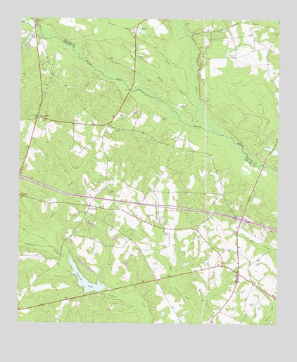
Covena, GA USGS Topographic Map
Click on map above to begin viewing in our Map Viewer.

This topographic map contains these locations and features:
Feature Name Type Latitude Longitude GNIS ID View Map
Boiling Springs ChurchChurchN32.4202°W82.4665°311627View Map
Brinson CemeteryCemeteryN32.4591°W82.4301°311805View Map
Courson PondReservoirN32.4236°W82.4620°347495View Map
CovenaPopulated PlaceN32.4971°W82.4424°313045View Map
Covena BranchStreamN32.4616°W82.4140°313046View Map
Dykes PondReservoirN32.3852°W82.4015°336261View Map
Dykes Pond DamDamN32.3852°W82.4015°336260View Map
Exit 20CrossingN32.4180°W82.3921°1705074View Map
Five PointsPopulated PlaceN32.4230°W82.4657°326287View Map
Gillis SpringsPopulated PlaceN32.4593°W82.4915°326301View Map
Herrington CemeteryCemeteryN32.4841°W82.4415°315347View Map
Holton CemeteryCemeteryN32.4607°W82.4487°315590View Map
Holtons ChapelChurchN32.4546°W82.4510°315592View Map
Little Ohoopee RiverStreamN32.4535°W82.4046°317136View Map
Moore CemeteryCemeteryN32.4849°W82.3962°318435View Map
Morningside ChurchChurchN32.4288°W82.4007°342640View Map
Mosley CemeteryCemeteryN32.3832°W82.3873°318519View Map
Outlaw Grove ChurchChurchN32.4724°W82.4865°320122View Map
Paulk DamReservoirN32.3852°W82.4065°336275View Map
Paulk Lake DamDamN32.3852°W82.4065°336274View Map
Phillips CemeteryCemeteryN32.4179°W82.4304°320455View Map
Phillips ChurchChurchN32.4288°W82.4557°320462View Map
Phillips GraveCemeteryN32.4643°W82.4207°320463View Map
Reedy CreekStreamN32.4041°W82.4776°321451View Map
Smith LakeReservoirN32.4473°W82.3796°341392View Map
Smith Lake DamDamN32.4468°W82.3815°341391View Map
Spring BranchStreamN32.4713°W82.4224°323362View Map
Stewart CemeteryCemeteryN32.4388°W82.4732°323603View Map
Sumner PondReservoirN32.4922°W82.4957°347504View Map
Thigpen ChapelChurchN32.4929°W82.4935°324066View Map
Thigpen CreekStreamN32.4949°W82.4910°324067View Map
Thigpen Mill CreekStreamN32.4907°W82.4976°324068View Map
Treutlen Fire Department Station 5BuildingN32.4590°W82.4914°2604825View Map
Treutlen Fire Department Station 6BuildingN32.4171°W82.4386°2604780View Map
Trumell PondReservoirN32.3918°W82.4132°336257View Map
Trumell Pond DamDamN32.3918°W82.4132°336256View Map
Wildwood LakeReservoirN32.3927°W82.4672°325293View Map
Wildwood Lake DamDamN32.3916°W82.4676°336131View Map
Wilkes CemeteryCemeteryN32.3818°W82.3837°325303View Map
Wilkes CemeteryCemeteryN32.4838°W82.4565°325304View Map

Note: Coordinates in the location and feature list above are referenced to NAD83 datum.


Copyright (C) 2008-2025 Ryan Niemi / Sunset Dynamics ... All Rights Reserved