TopoQuest Logo
Do you find TopoQuest useful?
Help keep TopoQuest running and adding new maps/features by donating!
Bitcoin:  19c7KJd3qBynnjoSw5npx9KScwjBe4ifkT
Litecoin:  LXs6TkuXGGXo1vDsWCkWVdjQX94eUKd6ui
Home View Maps Find Maps Find Places Resources & Links


Springfield South, Tennessee Topographic Map

USGS Map Title: Springfield South, TN
USGS Map MRC: 36086D8
DRG (GeoTIFF) Download: o36086d8.tif


Neighboring USGS Topographic Map Quads:


  Adams, TN  
36087E1
 

  Springfield North, TN  
36086E8
 

  Youngville, TN  
36086E7
 

  Pleasant View, TN  
36087D1
 

  Springfield South, TN  
36086D8
 

  Greenbrier, TN  
36086D7
 

  Ashland City, TN  
36087C1
 

  Forest Grove, TN  
36086C8
 

  Whites Creek, TN  
36086C7


Map MRC Location:

N37°
W87°
N37°
W86°
H8 H7 H6 H5 H4 H3 H2 H1
G8 G7 G6 G5 G4 G3 G2 G1
F8 F7 F6 F5 F4 F3 F2 F1
E8 E7 E6 E5 E4 E3 E2 E1
D8 D7 D6 D5 D4 D3 D2 D1
C8 C7 C6 C5 C4 C3 C2 C1
B8 B7 B6 B5 B4 B3 B2 B1
A8 A7 A6 A5 A4 A3 A2 A1
N36°
W87°
N36°
W86°

Springfield South, TN USGS 1:24K Topographic Map Preview:
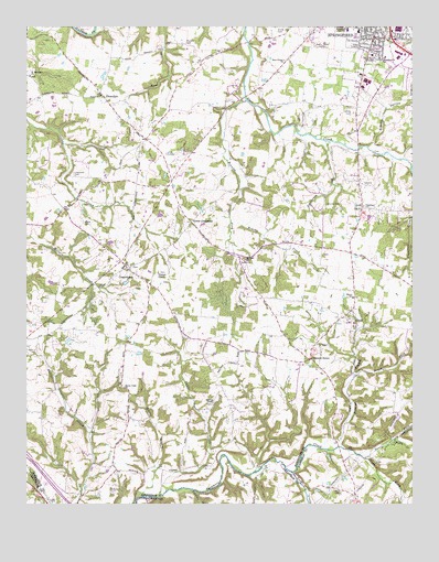
Springfield South, TN USGS Topographic Map
Click on map above to begin viewing in our Map Viewer.

This topographic map contains these locations and features:
Feature Name Type Latitude Longitude GNIS ID View Map
Addie (historical)Populated PlaceN36.3792°W86.9086°1313367View Map
Andersons Mill (historical)LocaleN36.4412°W86.9475°1316471View Map
Anthony CemeteryCemeteryN36.4087°W86.9403°1644153View Map
Battle CreekStreamN36.3775°W86.9572°1276479View Map
Battle Creek CemeteryCemeteryN36.4059°W86.9689°1644162View Map
Battle Creek ChurchChurchN36.4062°W86.9678°1304994View Map
Bednigo BranchStreamN36.3903°W86.8986°1305046View Map
Billy Cothron CemeteryCemeteryN36.4564°W86.9931°2084539View Map
Binkley CemeteryCemeteryN36.4620°W86.9147°1644175View Map
Black CemeteryCemeteryN36.4492°W86.9808°1305262View Map
Bransford High SchoolSchoolN36.4995°W86.8961°1305396View Map
Browing CemeteryCemeteryN36.4500°W86.9892°1644185View Map
Browns ForkStreamN36.4809°W86.9283°1305466View Map
Brush ForkStreamN36.4092°W86.8939°1278688View Map
Brushy CreekStreamN36.4492°W86.9336°1278700View Map
Chestnut GrovePopulated PlaceN36.4134°W86.9075°1280383View Map
Chestnut Grove School (historical)SchoolN36.4917°W86.9708°1316475View Map
Chestnut OrchardPopulated PlaceN36.4525°W86.8914°1647343View Map
Commissioner District 10CivilN36.4571°W86.8838°2464322View Map
Commissioner District 11CivilN36.4881°W86.9734°2464344View Map
Commissioner District 12CivilN36.4898°W86.8982°2464362View Map
Commissioner District 6CivilN36.4133°W86.9450°2464568View Map
Cooperstown CemeteryCemeteryN36.4373°W86.9656°1644209View Map
Cooperstown Church of ChristChurchN36.4367°W86.9667°1644210View Map
CoopertownPopulated PlaceN36.4375°W86.9672°1306100View Map
Coopertown Elementary SchoolSchoolN36.4367°W86.9689°1316477View Map
Coopertown Police DepartmentBuildingN36.4406°W86.9707°2766030View Map
Coopertown School (historical)SchoolN36.4359°W86.9575°1310186View Map
Copley CemeteryCemeteryN36.4050°W86.8822°1644211View Map
Crockett CemeteryCemeteryN36.4931°W86.9255°1644218View Map
Crockett CemeteryCemeteryN36.4659°W86.9344°1644219View Map
CrunkPopulated PlaceN36.4239°W86.8936°1281769View Map
Crunk CemeteryCemeteryN36.4989°W86.9183°1281770View Map
Dry ForkStreamN36.3914°W86.8811°1282967View Map
Fisher CemeteryCemeteryN36.4809°W86.9250°1644265View Map
FlewellynPopulated PlaceN36.4814°W86.9744°1284477View Map
Flewellyn Baptist ChurchChurchN36.4820°W86.9758°1644267View Map
Foreman FieldAirportN36.4574°W86.9468°2675501View Map
Frierson ChapelChurchN36.4356°W86.9569°1284954View Map
Glover CrossroadPopulated PlaceN36.4492°W86.9467°1315125View Map
Grace Baptist ChurchChurchN36.4987°W86.8844°1644278View Map
Grange School (historical)SchoolN36.4437°W86.8958°1316486View Map
Greater South Baptist ChurchChurchN36.4950°W86.8919°1316487View Map
Green CemeteryCemeteryN36.4434°W86.9539°1644281View Map
Head CemeteryCemeteryN36.4342°W86.9958°1644288View Map
Holmes CemeteryCemeteryN36.4409°W86.9956°1644310View Map
Lipscomb CemeteryCemeteryN36.4609°W86.9836°1291357View Map
Long CreekStreamN36.3837°W86.9142°1291935View Map
Martin CemeteryCemeteryN36.4425°W86.9411°1644340View Map
Martins ChapelChurchN36.4017°W86.9392°1292850View Map
Martins Chapel CemeteryCemeteryN36.4012°W86.9397°1644341View Map
McMahon HollowValleyN36.3949°W86.9793°1647344View Map
Miller CemeteryCemeteryN36.4295°W86.9825°1644352View Map
Morris CemeteryCemeteryN36.4750°W86.9203°1644356View Map
Mount Sharon CemeteryCemeteryN36.4234°W86.8964°1644363View Map
Mount Sharon Cumberland Presbyterian ChurchChurchN36.4239°W86.8956°1644364View Map
Mount Zion CemeteryCemeteryN36.4389°W86.9292°1644365View Map
Mount Zion ChurchChurchN36.4398°W86.9281°1294916View Map
Murphey CemeteryCemeteryN36.4534°W86.9875°1644366View Map
Murphy CemeteryCemeteryN36.4959°W86.9480°1295119View Map
New Chapel (historical)ChurchN36.4931°W86.9383°1316497View Map
New Chapel ChurchChurchN36.4914°W86.9161°1295462View Map
New Chapel School (historical)SchoolN36.4937°W86.9375°1316498View Map
Nobuzzn AirportAirportN36.4861°W86.9100°2675500View Map
Norris Mill (historical)LocaleN36.4537°W86.9694°1316499View Map
North Fork Sycamore CreekStreamN36.3878°W86.8911°1295917View Map
Northcrest Medical CenterHospitalN36.4785°W86.8869°2697307View Map
Palestine CemeteryCemeteryN36.4537°W86.8908°1644380View Map
Palestine ChurchChurchN36.4534°W86.8906°1296685View Map
Pleasant View Volunteer Fire Department Station 5BuildingN36.4329°W86.9582°2654146View Map
Poorhouse BranchStreamN36.4700°W86.9028°1298153View Map
Powell CemeteryCemeteryN36.4995°W86.9458°1644397View Map
Redding BranchStreamN36.3906°W86.9086°1310497View Map
Reeder CemeteryCemeteryN36.3864°W86.8811°1644406View Map
Reeves BranchStreamN36.3767°W86.9644°1299183View Map
Robertson County Farm (historical)LocaleN36.4537°W86.9014°1316508View Map
Robertson County LandfillLocaleN36.4575°W86.9078°2677894View Map
Saint Michaels CemeteryCemeteryN36.4873°W86.9986°1644420View Map
Saint Michaels ChurchChurchN36.4878°W86.9983°1300489View Map
Sharon Church (historical)ChurchN36.4292°W86.8942°1316510View Map
Shepherd CemeteryCemeteryN36.4978°W86.9189°1644424View Map
Sleepy HollowValleyN36.4690°W86.8878°1270506View Map
South Fork Sycamore CreekStreamN36.3875°W86.8911°1270889View Map
Springfield Country ClubLocaleN36.4848°W86.8753°1316513View Map
Springfield Special SchoolSchoolN36.4989°W86.8922°1316516View Map
Town of CoopertownCivilN36.4144°W86.9657°2406309View Map
Valley Grove School (historical)SchoolN36.4792°W86.9022°1316518View Map
Venters BranchStreamN36.3789°W86.9469°1273420View Map
Walker CemeteryCemeteryN36.3964°W86.9719°1644450View Map
WDBL-AM (Springfield)TowerN36.4953°W86.9072°1639993View Map
WDBL-FM (Springfield)TowerN36.4953°W86.9072°1640134View Map
Webb CemeteryCemeteryN36.3795°W86.9005°1274019View Map
White CemeteryCemeteryN36.4773°W86.8944°1274358View Map
Woodland Street SchoolSchoolN36.4923°W86.8850°1275048View Map

Note: Coordinates in the location and feature list above are referenced to NAD83 datum.


Copyright (C) 2008-2024 Ryan Niemi / Sunset Dynamics ... All Rights Reserved