TopoQuest Logo
Do you find TopoQuest useful?
Help keep TopoQuest running and adding new maps/features by donating!
Bitcoin:  19c7KJd3qBynnjoSw5npx9KScwjBe4ifkT
Litecoin:  LXs6TkuXGGXo1vDsWCkWVdjQX94eUKd6ui
Home View Maps Find Maps Find Places Resources & Links


Star Lake, Minnesota Topographic Map

USGS Map Title: Star Lake, MN
USGS Map MRC: 46095E7
DRG (GeoTIFF) Download: o46095e7.tif


Neighboring USGS Topographic Map Quads:


  Lake Franklin, MN  
46095F8
 

  Vergas, MN  
46095F7
 

  Frazee, MN  
46095F6
 

  Lake Lida, MN  
46095E8
 

  Star Lake, MN  
46095E7
 

  Dent, MN  
46095E6
 

  Heilberger Lake, MN  
46095D8
 

  Phelps, MN  
46095D7
 

  Walker Lake, MN  
46095D6


Map MRC Location:

N47°
W96°
N47°
W95°
H8 H7 H6 H5 H4 H3 H2 H1
G8 G7 G6 G5 G4 G3 G2 G1
F8 F7 F6 F5 F4 F3 F2 F1
E8 E7 E6 E5 E4 E3 E2 E1
D8 D7 D6 D5 D4 D3 D2 D1
C8 C7 C6 C5 C4 C3 C2 C1
B8 B7 B6 B5 B4 B3 B2 B1
A8 A7 A6 A5 A4 A3 A2 A1
N46°
W96°
N46°
W95°

Star Lake, MN USGS 1:24K Topographic Map Preview:
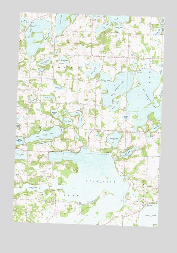
Star Lake, MN USGS Topographic Map
Click on map above to begin viewing in our Map Viewer.

This topographic map contains these locations and features:
Feature Name Type Latitude Longitude GNIS ID View Map
Alice LakeLakeN46.5918°W95.8109°639276View Map
Archie LakeLakeN46.5647°W95.7812°639424View Map
Berend LakeLakeN46.5970°W95.8354°639950View Map
Big McDonald LakeLakeN46.5811°W95.7669°640105View Map
Brown LakeReservoirN46.5683°W95.7903°1776240View Map
Brown LakeLakeN46.5710°W95.7906°640529View Map
Club LakeLakeN46.5569°W95.8748°641362View Map
Dora Post Offie (historical)Post OfficeN46.5944°W95.8403°2073020View Map
Dry Sand LakeReservoirN46.5366°W95.7703°1775925View Map
Dry Sand Lake Wildlife Management Unit DamDamN46.5366°W95.7703°1775924View Map
East Silent LakeLakeN46.5525°W95.8499°643108View Map
East Spirit LakeLakeN46.6113°W95.8613°643109View Map
Elbow LakeLakeN46.5662°W95.8229°643225View Map
Frank's Lodge and CampgroundLocaleN46.5236°W95.8639°2072955View Map
Heart LakeLakeN46.6201°W95.7521°644820View Map
Hoffman LakeLakeN46.5860°W95.8005°645055View Map
Kemp LakeLakeN46.6110°W95.8511°646085View Map
Krueger Loon Lake Seaplane BaseAirportN46.6219°W95.8367°660450View Map
Lake WilliamLakeN46.5959°W95.8524°654164View Map
McCollum LakeLakeN46.5912°W95.8573°647666View Map
McDonald LakeLakeN46.5693°W95.7586°2740447View Map
McDonald Lakes DamDamN46.5683°W95.7903°1776239View Map
Moore LakeLakeN46.5400°W95.8707°648068View Map
Ottos LakeLakeN46.5808°W95.8393°649063View Map
Pickerel LakeLakeN46.5541°W95.7613°649369View Map
Pine LakeLakeN46.5430°W95.7789°649478View Map
Pleasant LakeLakeN46.5472°W95.8519°649558View Map
Reames LakeLakeN46.5591°W95.7536°649858View Map
Redington Post Office (historical)Post OfficeN46.5153°W95.7514°2072986View Map
Round LakeLakeN46.5517°W95.7905°650346View Map
Round Lake Rest AreaLocaleN46.5564°W95.7861°2073150View Map
Sacred Heart Catholic Church CemeteryCemeteryN46.6003°W95.8442°2072707View Map
Saint John's Lutheran ChurchChurchN46.5564°W95.8022°2073097View Map
Saint Johns CemeteryCemeteryN46.5566°W95.8045°650692View Map
Seclusion Point CampgroundLocaleN46.5569°W95.7703°2073096View Map
Shallow LakeLakeN46.5612°W95.8320°651903View Map
Spirit Lake Post Office (historical)Post OfficeN46.6222°W95.8472°2072978View Map
Star LakeLakeN46.5215°W95.8101°652557View Map
Sunfish LakeLakeN46.5746°W95.8476°652817View Map
Tenter LakeLakeN46.6178°W95.7894°653089View Map
Township of DoraCivilN46.5860°W95.8437°663992View Map
Wagner LakeLakeN46.5654°W95.8425°653716View Map
Walde LakeLakeN46.5921°W95.7505°653729View Map
Weimann Community CemeteryCemeteryN46.6002°W95.7920°653893View Map
Wendt LakeLakeN46.6160°W95.7562°653911View Map
West McDonald LakeLakeN46.5821°W95.7886°653987View Map

Note: Coordinates in the location and feature list above are referenced to NAD83 datum.


Copyright (C) 2008-2024 Ryan Niemi / Sunset Dynamics ... All Rights Reserved