TopoQuest Logo
Do you find TopoQuest useful?
Help keep TopoQuest running and adding new maps/features by donating!
Bitcoin:  19c7KJd3qBynnjoSw5npx9KScwjBe4ifkT
Litecoin:  LXs6TkuXGGXo1vDsWCkWVdjQX94eUKd6ui
Home View Maps Find Maps Find Places Resources & Links


Phelps, Minnesota Topographic Map

USGS Map Title: Phelps, MN
USGS Map MRC: 46095D7
DRG (GeoTIFF) Download: o46095d7.tif


Neighboring USGS Topographic Map Quads:


  Lake Lida, MN  
46095E8
 

  Star Lake, MN  
46095E7
 

  Dent, MN  
46095E6
 

  Heilberger Lake, MN  
46095D8
 

  Phelps, MN  
46095D7
 

  Walker Lake, MN  
46095D6
 

  Wall Lake, MN  
46095C8
 

  Underwood, MN  
46095C7
 

  Battle Lake, MN  
46095C6


Map MRC Location:

N47°
W96°
N47°
W95°
H8 H7 H6 H5 H4 H3 H2 H1
G8 G7 G6 G5 G4 G3 G2 G1
F8 F7 F6 F5 F4 F3 F2 F1
E8 E7 E6 E5 E4 E3 E2 E1
D8 D7 D6 D5 D4 D3 D2 D1
C8 C7 C6 C5 C4 C3 C2 C1
B8 B7 B6 B5 B4 B3 B2 B1
A8 A7 A6 A5 A4 A3 A2 A1
N46°
W96°
N46°
W95°

Phelps, MN USGS 1:24K Topographic Map Preview:
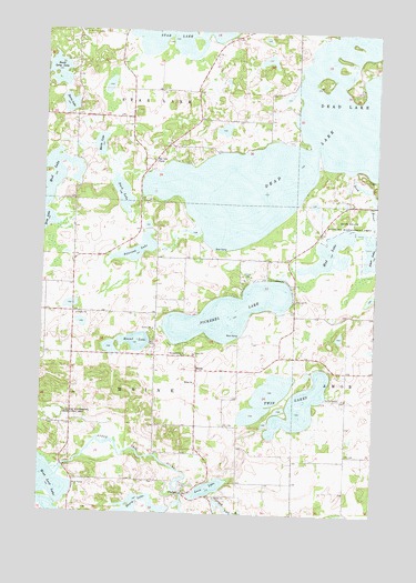
Phelps, MN USGS Topographic Map
Click on map above to begin viewing in our Map Viewer.

This topographic map contains these locations and features:
Feature Name Type Latitude Longitude GNIS ID View Map
Amor LakeLakeN46.4413°W95.7629°655128View Map
Amor State Wildlife Management AreaParkN46.4511°W95.7553°655130View Map
Berkey Post Office (historical)Post OfficeN46.4333°W95.8722°2073032View Map
Dead LakeLakeN46.4754°W95.7606°655949View Map
Duck LakeLakeN46.4577°W95.8459°642952View Map
Leon LakeLakeN46.3816°W95.8111°646603View Map
MainePopulated PlaceN46.4122°W95.8173°647396View Map
Maine ChurchChurchN46.4088°W95.8175°647397View Map
Maine Post Office (historical)Post OfficeN46.4122°W95.8169°2072996View Map
Maria LakeLakeN46.4703°W95.8545°647525View Map
Monitor Falls Post Office (historical)Post OfficeN46.3756°W95.8139°2072994View Map
Mud LakeLakeN46.4413°W95.7629°648299View Map
Otter Tail River DamDamN46.3800°W95.8220°1776242View Map
Otter Tail River ReservoirReservoirN46.3800°W95.8220°1776243View Map
Peterson LakeLakeN46.4433°W95.8395°649332View Map
PhelpsPopulated PlaceN46.3802°W95.8206°654877View Map
Phelps Mill BridgeBridgeN46.3800°W95.8217°2073141View Map
Phelps Post Office (historical)Post OfficeN46.3803°W95.8203°2072988View Map
Pickerel LakeLakeN46.4270°W95.8052°649367View Map
Round LakeLakeN46.4195°W95.8400°650340View Map
Saint James Catholic Church CemeteryCemeteryN46.4164°W95.8211°2072678View Map
Saint James ChurchChurchN46.4161°W95.8225°650621View Map
School Number 129 (historical)SchoolN46.4772°W95.8178°2128738View Map
School Number 137 (historical)SchoolN46.4781°W95.8747°2128737View Map
School Number 22 (historical)SchoolN46.3981°W95.8103°2128748View Map
School Number 241 (historical)SchoolN46.4322°W95.7800°2128739View Map
School Number 251 (historical)SchoolN46.4342°W95.8331°2128740View Map
Sharp LakeLakeN46.3758°W95.8386°651918View Map
Silent Vale CemeteryCemeteryN46.4086°W95.8153°2072677View Map
South Long LakeLakeN46.4891°W95.8706°652328View Map
Star Lake ChapelChurchN46.4663°W95.8345°652558View Map
Star Lake Post Office (historical)Post OfficeN46.4667°W95.8361°2072977View Map
Township of MaineCivilN46.4124°W95.8429°664878View Map
Township of Star LakeCivilN46.4993°W95.8434°665701View Map
Twin LakesLakeN46.4033°W95.7773°653444View Map
Zorns LakeLakeN46.4807°W95.8665°654504View Map

Note: Coordinates in the location and feature list above are referenced to NAD83 datum.


Copyright (C) 2008-2024 Ryan Niemi / Sunset Dynamics ... All Rights Reserved