TopoQuest Logo
Do you find TopoQuest useful?
Help keep TopoQuest running and adding new maps/features by donating!
Bitcoin:  19c7KJd3qBynnjoSw5npx9KScwjBe4ifkT
Litecoin:  LXs6TkuXGGXo1vDsWCkWVdjQX94eUKd6ui
Home View Maps Find Maps Find Places Resources & Links


Statesville West, North Carolina Topographic Map

USGS Map Title: Statesville West, NC
USGS Map MRC: 35080G8
DRG (GeoTIFF) Download: o35080g8.tif


Neighboring USGS Topographic Map Quads:


  Hiddenite, NC  
35081H1
 

  Central, NC  
35080H8
 

  Harmony, NC  
35080H7
 

  Stony Point, NC  
35081G1
 

  Statesville West, NC  
35080G8
 

  Statesville East, NC  
35080G7
 

  Catawba, NC  
35081F1
 

  Troutman, NC  
35080F8
 

  Shepherds, NC  
35080F7


Map MRC Location:

N36°
W81°
N36°
W80°
H8 H7 H6 H5 H4 H3 H2 H1
G8 G7 G6 G5 G4 G3 G2 G1
F8 F7 F6 F5 F4 F3 F2 F1
E8 E7 E6 E5 E4 E3 E2 E1
D8 D7 D6 D5 D4 D3 D2 D1
C8 C7 C6 C5 C4 C3 C2 C1
B8 B7 B6 B5 B4 B3 B2 B1
A8 A7 A6 A5 A4 A3 A2 A1
N35°
W81°
N35°
W80°

Statesville West, NC USGS 1:24K Topographic Map Preview:
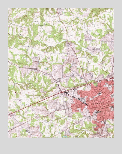
Statesville West, NC USGS Topographic Map
Click on map above to begin viewing in our Map Viewer.

This topographic map contains these locations and features:
Feature Name Type Latitude Longitude GNIS ID View Map
Abernathy Ball FieldParkN35.7846°W80.9098°1007797View Map
Anderson ParkParkN35.7901°W80.9017°1001698View Map
Arts and Science MuseumBuildingN35.8049°W80.8987°1001699View Map
Ashbrook ParkPopulated PlaceN35.7754°W80.9509°1006038View Map
Avery Sherrill SchoolSchoolN35.7660°W80.8892°980385View Map
Back CreekStreamN35.7501°W80.9192°1018894View Map
Bethel ChurchChurchN35.7965°W80.8926°981151View Map
Bethlehem ChurchChurchN35.7557°W80.9723°981218View Map
Beulah ChurchChurchN35.7601°W80.9829°981271View Map
Beverly HeightsPopulated PlaceN35.8093°W80.9042°1006042View Map
Blood of the Cross ChurchChurchN35.8443°W80.9006°981600View Map
BloomfieldPopulated PlaceN35.7907°W80.9159°1006031View Map
Bostian HeightsPopulated PlaceN35.7546°W80.9292°1006033View Map
Boulevard ChurchChurchN35.7699°W80.8906°981760View Map
Brady BranchStreamN35.8029°W80.9876°981815View Map
Bright Light ChurchChurchN35.8579°W80.9612°981902View Map
Bristol TerracePopulated PlaceN35.7835°W80.9398°1006036View Map
Broad Saint ChurchChurchN35.7812°W80.8804°981949View Map
Brookdale LakeReservoirN35.8007°W80.8753°999464View Map
Calvary ChurchChurchN35.7604°W80.8798°982452View Map
Calvary ChurchChurchN35.7862°W80.9062°982454View Map
Celeste HinkelPopulated PlaceN35.7571°W80.9754°1019588View Map
Celeste Hinkel SchoolSchoolN35.7554°W80.9756°1001703View Map
Chipley ParkPopulated PlaceN35.8437°W80.9040°1006030View Map
CloverdalePopulated PlaceN35.7860°W80.8956°1001704View Map
Cochran Saint ChurchChurchN35.7746°W80.9004°983323View Map
Colliers Lake ParkParkN35.8004°W80.8754°1001710View Map
Command ChurchChurchN35.7890°W80.9640°983414View Map
Concord ChurchChurchN35.8162°W80.9704°983432View Map
Cowin (historical)Populated PlaceN35.7512°W80.8942°1001712View Map
Crossroads ChurchChurchN35.7671°W80.8887°983797View Map
Davie Avenue SchoolSchoolN35.7879°W80.8856°983980View Map
Fairview ChurchChurchN35.8212°W80.8776°984918View Map
Fifth Saint ChurchChurchN35.7704°W80.8898°985069View Map
Forest Heights Shopping CenterLocaleN35.7971°W80.9012°1001714View Map
Fort Dobbs (historical)LocaleN35.8449°W80.9279°1001715View Map
Fourth Creek CemeteryCemeteryN35.7857°W80.8909°1007798View Map
Front Saint ChurchChurchN35.7832°W80.9120°985468View Map
Garys ChapelChurchN35.7612°W80.8937°985593View Map
Gateway Shopping CenterLocaleN35.8054°W80.8756°1001716View Map
Gospel TabernacleChurchN35.7832°W80.9062°985865View Map
Grace ParkParkN35.7771°W80.8934°1001718View Map
GreencrestPopulated PlaceN35.7857°W80.9315°1006034View Map
Gregory CreekStreamN35.8112°W80.8906°986136View Map
Halsey ChurchChurchN35.7757°W80.8826°986329View Map
Haywood ChapelChurchN35.8357°W80.8967°986555View Map
Hickory HillsPopulated PlaceN35.7710°W80.9506°1006037View Map
Holy Trinity ChurchChurchN35.7999°W80.8915°986997View Map
I-40 ParkParkN35.8062°W80.8967°1001721View Map
Iredell County Emergency Medical CenterBuildingN35.7807°W80.8885°2720582View Map
Iredell County Rescue SquadBuildingN35.8113°W80.9103°2720679View Map
Iredell County Sheriff's OfficeBuildingN35.7884°W80.8870°2769645View Map
Iredell Memorial HospitalHospitalN35.7996°W80.8782°1001723View Map
J W Lackey DamDamN35.8001°W80.9915°999466View Map
Kenneth Raymer LakeReservoirN35.7510°W80.9309°999348View Map
Kenneth Raymer Lake DamDamN35.7501°W80.9298°999349View Map
Kentwood ParkPopulated PlaceN35.7782°W80.9581°1006035View Map
KingswoodPopulated PlaceN35.8449°W80.8801°1006029View Map
LakesidePopulated PlaceN35.8026°W80.8959°1006041View Map
Lakewood ParkParkN35.8026°W80.8956°988104View Map
Lakewook Golf CourseLocaleN35.7593°W80.9434°1007801View Map
Liberty Hill (historical)Populated PlaceN35.8637°W80.9676°1001725View Map
LorayPopulated PlaceN35.8168°W80.9681°1021290View Map
Midway ChurchChurchN35.8604°W80.9979°989828View Map
Mills SchoolSchoolN35.7879°W80.9115°990028View Map
Mitchell CollegeSchoolN35.7832°W80.8942°990095View Map
MonticelloPopulated PlaceN35.7990°W80.9351°1001729View Map
Monticello ChurchChurchN35.7954°W80.9390°990157View Map
Monticello ChurchChurchN35.8110°W80.9529°990158View Map
Monticello HeightsPopulated PlaceN35.8093°W80.9251°1006046View Map
Monticello SchoolSchoolN35.8049°W80.9423°990159View Map
Monticello Volunteer Fire DepartmentBuildingN35.8067°W80.9436°2638153View Map
Morningside High SchoolSchoolN35.7804°W80.8781°1008004View Map
Morrison CreekStreamN35.8096°W80.8790°990270View Map
Mount Pleasant ChurchChurchN35.7790°W80.8848°990541View Map
Mulberry Saint SchoolSchoolN35.7785°W80.8898°990781View Map
New Center ChurchChurchN35.7615°W80.9459°990952View Map
NonameReservoirN35.7918°W80.9548°999447View Map
NonameReservoirN35.8001°W80.9915°999465View Map
North Carolina State Highway Patrol Troop F District 4BuildingN35.8062°W80.8786°2769931View Map
NorthmontPopulated PlaceN35.8168°W80.9240°1006045View Map
NorthviewPopulated PlaceN35.8046°W80.8867°1006040View Map
Northview SchoolSchoolN35.8057°W80.8826°991303View Map
Oakland HeightsPopulated PlaceN35.7926°W80.9067°1001737View Map
Oakwood CemeteryCemeteryN35.7908°W80.8755°991496View Map
Pressly ChurchChurchN35.7729°W80.8898°992788View Map
Race Saint ChurchChurchN35.7787°W80.8979°992972View Map
Race Saint SchoolSchoolN35.7904°W80.9009°992973View Map
Saint Johns ChurchChurchN35.7768°W80.9126°993955View Map
Saint Johns ChurchChurchN35.7965°W80.8979°993956View Map
Saint Josephs ChurchChurchN35.8593°W80.9573°993979View Map
Saint Marks ChurchChurchN35.7729°W80.8862°994017View Map
Saint Peters ChurchChurchN35.7682°W80.9631°994119View Map
Seventh Saint ChurchChurchN35.7671°W80.8923°994516View Map
Southern Bell Telephone OfficeBuildingN35.7812°W80.8862°1007799View Map
Southern Railroad StationBuildingN35.7771°W80.8837°1007800View Map
Southland Shopping CenterLocaleN35.7512°W80.8851°1001745View Map
StarmountPopulated PlaceN35.7985°W80.9067°1006043View Map
StatesvillePopulated PlaceN35.7826°W80.8873°995438View Map
Statesville Fire Department Station 1BuildingN35.7816°W80.8889°2638520View Map
Statesville Fire Department Station 2BuildingN35.7865°W80.9191°2639106View Map
Statesville Police DepartmentBuildingN35.7826°W80.8850°2769648View Map
Statesville Post OfficePost OfficeN35.7775°W80.9100°2768305View Map
Statesville QuarryMineN35.8028°W80.9228°2649302View Map
Statesville Regional AirportAirportN35.7670°W80.9494°997967View Map
Statesville Senior High SchoolSchoolN35.7887°W80.8892°1001746View Map
Statesville WestPopulated PlaceN35.7854°W80.9309°1001747View Map
T S Stewart DamDamN35.7918°W80.9548°999448View Map
Temple ChurchChurchN35.8118°W80.9040°995921View Map
The Bible Way ChurchChurchN35.7949°W80.8906°995957View Map
The Connection ChurchChurchN35.7553°W80.9931°2575702View Map
Thompson Junior High SchoolSchoolN35.7787°W80.8976°996055View Map
Town and Country Shopping CenterLocaleN35.8032°W80.9101°1001749View Map
Township of ConcordCivilN35.8452°W80.9792°1026816View Map
Township of StatesvilleCivilN35.7727°W80.8960°1026825View Map
Trinity ChurchChurchN35.7985°W80.9006°996249View Map
Trinity ChurchChurchN35.8629°W80.9387°996250View Map
Trinity Volunteer Fire DepartmentBuildingN35.8689°W80.9404°2638547View Map
True Temple ChurchChurchN35.8410°W80.9284°996275View Map
Vance House MuseumBuildingN35.7785°W80.8934°1001755View Map
Washington HeightsPopulated PlaceN35.7624°W80.8973°1006032View Map
Watts (historical)Populated PlaceN35.7740°W80.9434°1001756View Map
Watts ParkParkN35.7751°W80.9101°1001757View Map
Wendover HillsPopulated PlaceN35.7971°W80.9187°1006044View Map
West Iredell High SchoolSchoolN35.7907°W80.9931°1001758View Map
West Iredell Middle SchoolSchoolN35.7860°W80.9873°1001759View Map
West Park Shopping CenterLocaleN35.7896°W80.9445°1001760View Map
West StatesvillePopulated PlaceN35.7804°W80.9242°1001761View Map
Western Avenue ChurchChurchN35.7754°W80.8915°997057View Map
Westgate Shopping CenterLocaleN35.7812°W80.9059°1001762View Map
WestoverPopulated PlaceN35.7896°W80.9473°1006039View Map
WestwoodPopulated PlaceN35.7960°W80.8873°1001763View Map
WFMX-FM (Statesville)TowerN35.8026°W80.8915°1018302View Map
Woods Drive DamDamN35.8018°W80.8831°999478View Map
Woods Drive LakeReservoirN35.8018°W80.8831°999477View Map
WSIC-AM (Statesville)TowerN35.8026°W80.8915°1018503View Map
Yadkin ChurchChurchN35.8685°W80.9390°997677View Map

Note: Coordinates in the location and feature list above are referenced to NAD83 datum.


Copyright (C) 2008-2024 Ryan Niemi / Sunset Dynamics ... All Rights Reserved