TopoQuest Logo
Do you find TopoQuest useful?
Help keep TopoQuest running and adding new maps/features by donating!
Bitcoin:  19c7KJd3qBynnjoSw5npx9KScwjBe4ifkT
Litecoin:  LXs6TkuXGGXo1vDsWCkWVdjQX94eUKd6ui
Home View Maps Find Maps Find Places Resources & Links


Stony Point, North Carolina Topographic Map

USGS Map Title: Stony Point, NC
USGS Map MRC: 35081G1
DRG (GeoTIFF) Download: o35081g1.tif


Neighboring USGS Topographic Map Quads:


  Taylorsville, NC  
35081H2
 

  Hiddenite, NC  
35081H1
 

  Central, NC  
35080H8
 

  Millersville, NC  
35081G2
 

  Stony Point, NC  
35081G1
 

  Statesville West, NC  
35080G8
 

  Newton, NC  
35081F2
 

  Catawba, NC  
35081F1
 

  Troutman, NC  
35080F8


Map MRC Location:

N36°
W82°
N36°
W81°
H8 H7 H6 H5 H4 H3 H2 H1
G8 G7 G6 G5 G4 G3 G2 G1
F8 F7 F6 F5 F4 F3 F2 F1
E8 E7 E6 E5 E4 E3 E2 E1
D8 D7 D6 D5 D4 D3 D2 D1
C8 C7 C6 C5 C4 C3 C2 C1
B8 B7 B6 B5 B4 B3 B2 B1
A8 A7 A6 A5 A4 A3 A2 A1
N35°
W82°
N35°
W81°

Stony Point, NC USGS 1:24K Topographic Map Preview:
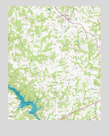
Stony Point, NC USGS Topographic Map
Click on map above to begin viewing in our Map Viewer.

This topographic map contains these locations and features:
Feature Name Type Latitude Longitude GNIS ID View Map
Bethel ChurchChurchN35.7640°W81.0651°981149View Map
Beulah CemeteryCemeteryN35.7704°W81.0067°981257View Map
Big BranchStreamN35.8174°W81.0909°981346View Map
Bradford CrossroadsPopulated PlaceN35.7835°W81.0048°1019272View Map
Brevard (historical)Populated PlaceN35.8474°W81.0615°1001700View Map
Bunker Hill High SchoolSchoolN35.7541°W81.1195°982258View Map
C A Lackey DamDamN35.8701°W81.0681°999626View Map
CatfishPopulated PlaceN35.7551°W81.1179°1006157View Map
Concord ChurchChurchN35.8387°W81.1142°983433View Map
Doctors BranchStreamN35.7979°W81.0040°1004649View Map
Elk Shoals ChurchChurchN35.8151°W81.1040°984707View Map
Elk Shoals CreekStreamN35.7874°W81.1217°984708View Map
Flying BJ AirportAirportN35.8138°W81.0700°2679269View Map
Goble CreekStreamN35.7537°W81.0451°985754View Map
Guys BranchStreamN35.8293°W81.0817°986273View Map
Hill LakeReservoirN35.8435°W81.0181°999561View Map
Hill Lake DamDamN35.8435°W81.0181°999560View Map
Island FordLocaleN35.7532°W81.0867°1001724View Map
Lake LookoutReservoirN35.7679°W81.1018°999363View Map
Lookout Shoals DamDamN35.7574°W81.0906°989027View Map
Lookout Shoals LakeReservoirN35.7574°W81.0906°989028View Map
Marvin ChurchChurchN35.7937°W81.1051°989413View Map
Moores (historical)Populated PlaceN35.7554°W81.0879°1001730View Map
Mount Hermon ChurchChurchN35.7793°W81.0031°990405View Map
Mount Nebo ChurchChurchN35.8721°W81.0809°990450View Map
Mount Wesley ChurchChurchN35.8704°W81.1134°990620View Map
New Amity ChurchChurchN35.8401°W81.0045°990923View Map
New Salem ChurchChurchN35.8501°W81.0631°991096View Map
New Sterling ChurchChurchN35.7943°W81.0434°991102View Map
NonameReservoirN35.8717°W81.0694°999625View Map
Philadelphia ChurchChurchN35.8535°W81.0645°992128View Map
Pleasant Home ChurchChurchN35.8468°W81.1162°992545View Map
Providence ChurchChurchN35.7510°W81.0142°992877View Map
ScottsPopulated PlaceN35.8429°W81.0092°994432View Map
Scotts Post OfficePost OfficeN35.8439°W81.0102°2768303View Map
Scotts SchoolSchoolN35.8437°W81.0142°1001739View Map
SharonPopulated PlaceN35.7754°W81.0670°994579View Map
Sharon Elementary SchoolSchoolN35.7709°W81.0611°1001740View Map
Stony PointPopulated PlaceN35.8635°W81.0473°995579View Map
Stony Point Census Designated PlaceCensusN35.8670°W81.0470°2402898View Map
Stony Point Post OfficePost OfficeN35.8624°W81.0470°2768299View Map
Stony Point Volunteer Fire DepartmentBuildingN35.8614°W81.0448°2638228View Map
Sunrise BeachPopulated PlaceN35.7626°W81.0973°1022846View Map
Third Creek ChurchChurchN35.8599°W81.0754°996023View Map
Third Creek Watershed Dam Number NineDamN35.8368°W81.0298°999549View Map
Third Creek Watershed Dam TenDamN35.8151°W81.0215°999500View Map
Township of MillersCivilN35.8338°W81.1110°1026359View Map
Township of ShilohCivilN35.7685°W81.0226°1026824View Map
West Iredell Volunteer Fire DepartmentBuildingN35.7824°W81.0036°2639024View Map

Note: Coordinates in the location and feature list above are referenced to NAD83 datum.


Copyright (C) 2008-2024 Ryan Niemi / Sunset Dynamics ... All Rights Reserved