TopoQuest Logo
Do you find TopoQuest useful?
Help keep TopoQuest running and adding new maps/features by donating!
Bitcoin:  19c7KJd3qBynnjoSw5npx9KScwjBe4ifkT
Litecoin:  LXs6TkuXGGXo1vDsWCkWVdjQX94eUKd6ui
Home View Maps Find Maps Find Places Resources & Links


Stemler Ridge, Oregon Topographic Map

USGS Map Title: Stemler Ridge, OR
USGS Map MRC: 43118G1
DRG (GeoTIFF) Download: o43118g1.tif


Neighboring USGS Topographic Map Quads:


  Beulah, OR  
43118H2
 

  De Armond Mountain, OR  
43118H1
 

  Westfall Butte, OR  
43117H8
 

  Petes Mountain, OR  
43118G2
 

  Stemler Ridge, OR  
43118G1
 

  Jonesboro, OR  
43117G8
 

  Selle Gap, OR  
43118F2
 

  Juntura, OR  
43118F1
 

  Monument Peak, OR  
43117F8


Map MRC Location:

N44°
W119°
N44°
W118°
H8 H7 H6 H5 H4 H3 H2 H1
G8 G7 G6 G5 G4 G3 G2 G1
F8 F7 F6 F5 F4 F3 F2 F1
E8 E7 E6 E5 E4 E3 E2 E1
D8 D7 D6 D5 D4 D3 D2 D1
C8 C7 C6 C5 C4 C3 C2 C1
B8 B7 B6 B5 B4 B3 B2 B1
A8 A7 A6 A5 A4 A3 A2 A1
N43°
W119°
N43°
W118°

Stemler Ridge, OR USGS 1:24K Topographic Map Preview:
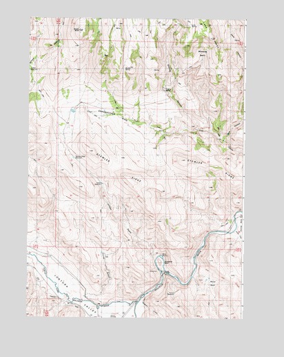
Stemler Ridge, OR USGS Topographic Map
Click on map above to begin viewing in our Map Viewer.

This topographic map contains these locations and features:
Feature Name Type Latitude Longitude GNIS ID View Map
Adobe ReservoirReservoirN43.8058°W118.0823°1116781View Map
Beulah ButteSummitN43.8696°W118.0966°1117567View Map
Beulah CreekStreamN43.8346°W118.0816°1131776View Map
Beulah Creek ReservoirReservoirN43.8363°W118.0814°1131774View Map
Boney BasinBasinN43.7646°W118.0216°1117928View Map
Boney Basin ReservoirReservoirN43.7662°W118.0213°1131761View Map
Boulder SpringSpringN43.8538°W118.0697°1131778View Map
Boulder Spring Number 2SpringN43.8565°W118.0260°1131779View Map
Calf Creek WaterholeReservoirN43.8360°W118.0995°1131777View Map
Cave CanyonValleyN43.8240°W118.0118°1118708View Map
Currey CanyonValleyN43.7590°W118.0880°1119634View Map
Currey Canyon ReservoirReservoirN43.7772°W118.0818°1131762View Map
Currey ReservoirReservoirN43.8531°W118.1246°1119635View Map
Dishrag CanyonValleyN43.8299°W118.0274°1119957View Map
Dishrag SpringSpringN43.8452°W118.0466°1119958View Map
Dugout CreekStreamN43.7568°W118.0585°1120204View Map
Dugout ReservoirReservoirN43.8002°W118.1100°1131765View Map
Forest ReservoirReservoirN43.8579°W118.0251°1131768View Map
Grasshopper FlatFlatN43.8374°W118.0757°1121309View Map
Gwinn (historical)LocaleN43.7929°W118.0013°1167771View Map
Gwynn BridgeBridgeN43.7860°W118.0093°1638665View Map
Harris ReservoirReservoirN43.8048°W118.0161°1131757View Map
Horseshoe BendBendN43.7729°W118.0482°1122034View Map
Horseshoe Bend BridgeBridgeN43.7696°W118.0471°1638664View Map
Horseshoe Bend SpringSpringN43.7865°W118.0677°1131756View Map
Hunter CreekStreamN43.7865°W118.0043°1122149View Map
Joyce ReservoirReservoirN43.7979°W118.0792°1131764View Map
Juniper GulchValleyN43.7749°W118.0510°1122592View Map
Juntura Investment Company CanalCanalN43.7624°W118.1177°1131763View Map
Juntura ValleyValleyN43.7549°W118.0618°1122621View Map
Lake RidgeRidgeN43.8668°W118.0202°1122907View Map
Lake SpringSpringN43.8720°W118.0316°1122911View Map
Mustang BasinBasinN43.8593°W118.0249°1124563View Map
North Fork Malheur RiverStreamN43.7568°W118.0610°1146976View Map
Poverty SpringSpringN43.8664°W118.0067°1131769View Map
Red Willow SpringSpringN43.7863°W118.0513°1131758View Map
Stemler BasinBasinN43.7899°W118.0046°1127588View Map
Stemler RidgeRidgeN43.8074°W118.0668°1127589View Map
Stemler Ridge ReservoirReservoirN43.8165°W118.0989°1127590View Map
Tunnel ReservoirReservoirN43.7604°W118.0396°1131760View Map
Warm SpringSpringN43.7760°W118.0479°1128642View Map

Note: Coordinates in the location and feature list above are referenced to NAD83 datum.


Copyright (C) 2008-2024 Ryan Niemi / Sunset Dynamics ... All Rights Reserved