TopoQuest Logo
Do you find TopoQuest useful?
Help keep TopoQuest running and adding new maps/features by donating!
Bitcoin:  19c7KJd3qBynnjoSw5npx9KScwjBe4ifkT
Litecoin:  LXs6TkuXGGXo1vDsWCkWVdjQX94eUKd6ui
Home View Maps Find Maps Find Places Resources & Links


Beulah, Oregon Topographic Map

USGS Map Title: Beulah, OR
USGS Map MRC: 43118H2
DRG (GeoTIFF) Download: o43118h2.tif


Neighboring USGS Topographic Map Quads:


  Buck Trough Spring, OR  
44118A3
 

  Castle Rock, OR  
44118A2
 

  Hunter Mountain, OR  
44118A1
 

  Cottonwood Reservoir, OR  
43118H3
 

  Beulah, OR  
43118H2
 

  De Armond Mountain, OR  
43118H1
 

  Drinkwater Pass, OR  
43118G3
 

  Petes Mountain, OR  
43118G2
 

  Stemler Ridge, OR  
43118G1


Map MRC Location:

N44°
W119°
N44°
W118°
H8 H7 H6 H5 H4 H3 H2 H1
G8 G7 G6 G5 G4 G3 G2 G1
F8 F7 F6 F5 F4 F3 F2 F1
E8 E7 E6 E5 E4 E3 E2 E1
D8 D7 D6 D5 D4 D3 D2 D1
C8 C7 C6 C5 C4 C3 C2 C1
B8 B7 B6 B5 B4 B3 B2 B1
A8 A7 A6 A5 A4 A3 A2 A1
N43°
W119°
N43°
W118°

Beulah, OR USGS 1:24K Topographic Map Preview:
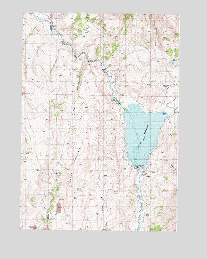
Beulah, OR USGS Topographic Map
Click on map above to begin viewing in our Map Viewer.

This topographic map contains these locations and features:
Feature Name Type Latitude Longitude GNIS ID View Map
Agency MountainSummitN43.9127°W118.2044°1116786View Map
Agency ValleyValleyN43.9440°W118.1396°1116787View Map
Agency Valley CemeteryCemeteryN43.9585°W118.1379°1116788View Map
Agency Valley DamDamN43.9104°W118.1532°1116789View Map
BeulahPopulated PlaceN43.9065°W118.1527°1136064View Map
Beulah Post Office (historical)Post OfficeN43.9065°W118.1527°1164914View Map
Beulah ReservoirReservoirN43.9315°W118.1548°1117569View Map
Beulah Reservoir RampLocaleN43.9122°W118.1537°2700028View Map
Box SpringSpringN43.8933°W118.2077°1118016View Map
Butler RanchLocaleN43.9638°W118.1288°1162317View Map
Castle Rock CreekStreamN43.9915°W118.2271°1118667View Map
Charcoal SpringSpringN43.9971°W118.1941°1131782View Map
Cherry SpringSpringN43.8988°W118.2022°1118864View Map
Dry LakeLakeN43.9797°W118.1936°1131783View Map
Fan SpringSpringN43.8902°W118.1941°1131770View Map
Fox SpringSpringN43.9974°W118.2001°1131785View Map
Green Spot SpringSpringN43.9578°W118.1519°1131784View Map
Jerry CanyonValleyN43.9640°W118.1316°1122411View Map
Lower Mud SpringSpringN43.8754°W118.1800°1123574View Map
Morrison SpringSpringN43.9968°W118.2258°1131786View Map
Murphy Brothers RanchLocaleN43.9582°W118.1288°1162319View Map
Murphy Ranch AirportAirportN43.9583°W118.1306°2646026View Map
Scott DamDamN43.9729°W118.1320°1158803View Map
Scott ReservoirReservoirN43.9726°W118.1306°1126691View Map
Spring CreekStreamN43.9999°W118.2430°1127419View Map
T J SpringSpringN43.8801°W118.1318°1131773View Map
Thorn SpringSpringN43.8843°W118.1503°1128046View Map
Warm Springs CreekStreamN43.9418°W118.1330°1128654View Map
Water GulchValleyN43.9729°W118.2002°1128712View Map

Note: Coordinates in the location and feature list above are referenced to NAD83 datum.


Copyright (C) 2008-2025 Ryan Niemi / Sunset Dynamics ... All Rights Reserved