TopoQuest Logo
Do you find TopoQuest useful?
Help keep TopoQuest running and adding new maps/features by donating!
Bitcoin:  19c7KJd3qBynnjoSw5npx9KScwjBe4ifkT
Litecoin:  LXs6TkuXGGXo1vDsWCkWVdjQX94eUKd6ui
Home View Maps Find Maps Find Places Resources & Links


Streetman, Texas Topographic Map

USGS Map Title: Streetman, TX
USGS Map MRC: 31096H3
DRG (GeoTIFF) Download: o31096h3.tif


Neighboring USGS Topographic Map Quads:


  Corsicana, TX  
32096A4
 

  Powell, TX  
32096A3
 

  Goodlow Park, TX  
32096A2
 

  Richland, TX  
31096H4
 

  Streetman, TX  
31096H3
 

  Winkler, TX  
31096H2
 

  Wortham, TX  
31096G4
 

  Kirvin, TX  
31096G3
 

  Stewards Mill, TX  
31096G2


Map MRC Location:

N32°
W97°
N32°
W96°
H8 H7 H6 H5 H4 H3 H2 H1
G8 G7 G6 G5 G4 G3 G2 G1
F8 F7 F6 F5 F4 F3 F2 F1
E8 E7 E6 E5 E4 E3 E2 E1
D8 D7 D6 D5 D4 D3 D2 D1
C8 C7 C6 C5 C4 C3 C2 C1
B8 B7 B6 B5 B4 B3 B2 B1
A8 A7 A6 A5 A4 A3 A2 A1
N31°
W97°
N31°
W96°

Streetman, TX USGS 1:24K Topographic Map Preview:
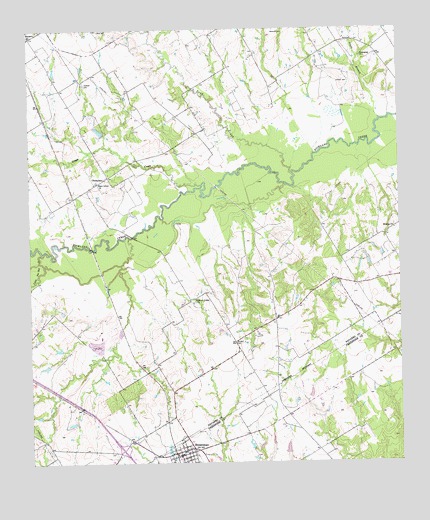
Streetman, TX USGS Topographic Map
Click on map above to begin viewing in our Map Viewer.

This topographic map contains these locations and features:
Feature Name Type Latitude Longitude GNIS ID View Map
B T Averheart Airport (historical)AirportN31.9002°W96.3114°1387599View Map
Birdston CemeteryCemeteryN31.9102°W96.3039°1330707View Map
Birdston Valley ChurchChurchN31.9213°W96.3197°1330708View Map
Byrt Airport (historical)AirportN31.9207°W96.2661°1387600View Map
CheneyboroPopulated PlaceN31.9577°W96.3486°1378117View Map
City of EurekaCivilN31.9902°W96.2824°2410464View Map
Crab CreekStreamN31.9585°W96.2858°1333611View Map
Emerson Dam Number 1DamN31.8918°W96.2803°1863714View Map
Emerson Dam Number 2DamN31.8785°W96.2886°1863716View Map
Emerson Lake Number 1ReservoirN31.8918°W96.2803°1863715View Map
Emerson Lake Number 2ReservoirN31.8791°W96.2888°1863717View Map
Friendship ChurchChurchN31.9913°W96.2616°1336230View Map
Grape CreekStreamN31.9552°W96.3164°1336828View Map
Gunn CemeteryCemeteryN31.9968°W96.2650°1337133View Map
Handcock CemeteryCemeteryN31.9990°W96.2880°1337296View Map
Hopewell CemeteryCemeteryN31.9843°W96.3561°1338055View Map
Johnson CemeteryCemeteryN31.9849°W96.2666°1338782View Map
Jones BranchStreamN31.9738°W96.2564°1338832View Map
Little Pin Oak CreekStreamN31.9357°W96.3708°1340153View Map
Midway ChurchChurchN31.9424°W96.2519°1341562View Map
Silent Grove ChurchChurchN31.9560°W96.3519°1347119View Map
StreetmanPopulated PlaceN31.8774°W96.3250°1347998View Map
Streetman Post OfficePost OfficeN31.8777°W96.3242°2732296View Map
Texas Industries LeveeDamN31.9135°W96.3453°1859478View Map
Town of StreetmanCivilN31.8787°W96.3306°2413342View Map

Note: Coordinates in the location and feature list above are referenced to NAD83 datum.


Copyright (C) 2008-2025 Ryan Niemi / Sunset Dynamics ... All Rights Reserved