TopoQuest Logo
Do you find TopoQuest useful?
Help keep TopoQuest running and adding new maps/features by donating!
Bitcoin:  19c7KJd3qBynnjoSw5npx9KScwjBe4ifkT
Litecoin:  LXs6TkuXGGXo1vDsWCkWVdjQX94eUKd6ui
Home View Maps Find Maps Find Places Resources & Links


Pueblo Viejo Mesa, New Mexico Topographic Map

USGS Map Title: Pueblo Viejo Mesa, NM
USGS Map MRC: 34107E5
DRG (GeoTIFF) Download: o34107e5.tif


Neighboring USGS Topographic Map Quads:


  Mecate Meadow, NM  
34107F6
 

  Broom Mountain, NM  
34107F5
 

  Cerro Del Oro, NM  
34107F4
 

  Wiley Mesa, NM  
34107E6
 

  Pueblo Viejo Mesa, NM  
34107E5
 

  Field Ranch, NM  
34107E4
 

  D Cross Mountain, NM  
34107D6
 

  Table Mountain, NM  
34107D5
 

  Puertecito, NM  
34107D4


Map MRC Location:

N35°
W108°
N35°
W107°
H8 H7 H6 H5 H4 H3 H2 H1
G8 G7 G6 G5 G4 G3 G2 G1
F8 F7 F6 F5 F4 F3 F2 F1
E8 E7 E6 E5 E4 E3 E2 E1
D8 D7 D6 D5 D4 D3 D2 D1
C8 C7 C6 C5 C4 C3 C2 C1
B8 B7 B6 B5 B4 B3 B2 B1
A8 A7 A6 A5 A4 A3 A2 A1
N34°
W108°
N34°
W107°

Pueblo Viejo Mesa, NM USGS 1:24K Topographic Map Preview:
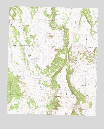
Pueblo Viejo Mesa, NM USGS Topographic Map
Click on map above to begin viewing in our Map Viewer.

This topographic map contains these locations and features:
Feature Name Type Latitude Longitude GNIS ID View Map
Caņon de la MoscaValleyN34.5981°W107.6056°897742View Map
Caņon de la TerneraValleyN34.5509°W107.5209°897745View Map
East Mesa Water WellWellN34.5212°W107.5473°925820View Map
Foothill TankReservoirN34.5233°W107.5119°889127View Map
Lagnuna Del OroLakeN34.6188°W107.5069°890866View Map
Mesa Water WellWellN34.6117°W107.5484°919811View Map
Number 31 WindmillLocaleN34.5228°W107.6187°898068View Map
Number 7 WindmillLocaleN34.5928°W107.6192°898071View Map
Number 7 WM Water WellWellN34.5937°W107.6189°918517View Map
Ojo TerneraSpringN34.5639°W107.5324°898105View Map
Oro WindmillLocaleN34.6195°W107.5028°892932View Map
Oro Windmill Water WellWellN34.6195°W107.5028°919792View Map
Pueblo Viejo MesaSummitN34.5689°W107.5956°899859View Map
Puerto de la TerneraLocaleN34.5609°W107.5303°893530View Map
Red Lake RanchLocaleN34.6089°W107.5675°924510View Map
Tres Hermanos MesaSummitN34.5126°W107.5317°911804View Map
Turner Water WellWellN34.5284°W107.5745°925822View Map
Victorino MesaSummitN34.6189°W107.5220°897507View Map
Victorino RanchLocaleN34.6095°W107.5656°896136View Map
Victorino SpringSpringN34.6115°W107.5610°896137View Map
Victorino WellWellN34.5639°W107.5898°896138View Map
Victorio Water WellWellN34.5953°W107.5759°918584View Map

Note: Coordinates in the location and feature list above are referenced to NAD83 datum.


Copyright (C) 2008-2025 Ryan Niemi / Sunset Dynamics ... All Rights Reserved