TopoQuest Logo
Do you find TopoQuest useful?
Help keep TopoQuest running and adding new maps/features by donating!
Bitcoin:  19c7KJd3qBynnjoSw5npx9KScwjBe4ifkT
Litecoin:  LXs6TkuXGGXo1vDsWCkWVdjQX94eUKd6ui
Home View Maps Find Maps Find Places Resources & Links


Tallassee, Alabama Topographic Map

USGS Map Title: Tallassee, AL
USGS Map MRC: 32085E8
DRG (GeoTIFF) Download: o32085e8.tif


Neighboring USGS Topographic Map Quads:


  Eclectic, AL  
32086F1
 

  Red Hill, AL  
32085F8
 

  Ponders, AL  
32085F7
 

  Claud, AL  
32086E1
 

  Tallassee, AL  
32085E8
 

  Carrville, AL  
32085E7
 

  Brassell, AL  
32086D1
 

  Shorter, AL  
32085D8
 

  La Place, AL  
32085D7


Map MRC Location:

N33°
W86°
N33°
W85°
H8 H7 H6 H5 H4 H3 H2 H1
G8 G7 G6 G5 G4 G3 G2 G1
F8 F7 F6 F5 F4 F3 F2 F1
E8 E7 E6 E5 E4 E3 E2 E1
D8 D7 D6 D5 D4 D3 D2 D1
C8 C7 C6 C5 C4 C3 C2 C1
B8 B7 B6 B5 B4 B3 B2 B1
A8 A7 A6 A5 A4 A3 A2 A1
N32°
W86°
N32°
W85°

Tallassee, AL USGS 1:24K Topographic Map Preview:
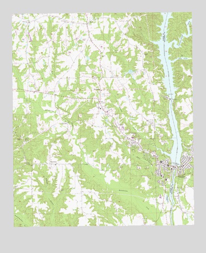
Tallassee, AL USGS Topographic Map
Click on map above to begin viewing in our Map Viewer.

This topographic map contains these locations and features:
Feature Name Type Latitude Longitude GNIS ID View Map
Annie T Gregory LakeReservoirN32.5986°W85.9473°130750View Map
Annie T Gregory Lake DamDamN32.5968°W85.9466°130749View Map
Bethlehem East ChurchChurchN32.6207°W85.9427°137144View Map
BurlingtonPopulated PlaceN32.5804°W85.9388°156136View Map
Butts MillPopulated PlaceN32.5612°W85.9627°156140View Map
Carrville Baptist ChurchChurchN32.5496°W85.8761°158683View Map
Chana CreekPopulated PlaceN32.6210°W85.9883°1699959View Map
Chana Creek Primitive Baptist ChurchChurchN32.6199°W85.9894°115947View Map
City of TallasseeCivilN32.5314°W85.8912°2405565View Map
Club Yamas and Golf CourseLocaleN32.6101°W85.9508°137165View Map
Community HospitalHospitalN32.5342°W85.9123°2669273View Map
Coon CreekStreamN32.5965°W85.8905°151737View Map
Dubois Mill (historical)LocaleN32.5237°W85.8908°137182View Map
East Tallassee Baptist ChurchChurchN32.5374°W85.8786°158989View Map
East Tallassee Church of ChristChurchN32.5396°W85.8775°158689View Map
East Tallassee Grammar School (historical)SchoolN32.5332°W85.8841°137411View Map
East Tallassee Post OfficePost OfficeN32.5349°W85.8813°167969View Map
East Tallassee United Methodist ChurchChurchN32.5343°W85.8827°158990View Map
First Baptist ChurchChurchN32.5346°W85.8950°137199View Map
First Presbyterian ChurchChurchN32.5401°W85.8761°158691View Map
First United Methodist ChurchChurchN32.5362°W85.8980°158623View Map
Flat Rock ChurchChurchN32.5518°W85.9919°118393View Map
Flat Rock School (historical)SchoolN32.5501°W85.9925°137202View Map
FriendshipPopulated PlaceN32.5371°W85.9747°118650View Map
Friendship Baptist ChurchChurchN32.5362°W85.9827°158986View Map
Friendship CemeteryCemeteryN32.5385°W85.9744°154693View Map
Friendship School (historical)SchoolN32.5371°W85.9722°137205View Map
Friendship Volunteer Fire DepartmentBuildingN32.5372°W85.9735°2691162View Map
Graveyard CreekStreamN32.5415°W85.8916°119280View Map
Harrington BranchStreamN32.5551°W85.9591°137220View Map
Hornsby CemeteryCemeteryN32.6232°W85.9138°137225View Map
HornsbytownPopulated PlaceN32.5507°W85.9169°137226View Map
Jerusalem ChurchChurchN32.5015°W85.9011°137233View Map
JordanvillePopulated PlaceN32.5315°W85.9000°137235View Map
KentPopulated PlaceN32.6190°W85.9486°121157View Map
Kent Community CenterBuildingN32.6112°W85.9458°137239View Map
Lewis CreekStreamN32.5196°W85.8919°121518View Map
LibertyPopulated PlaceN32.5215°W85.9980°137246View Map
Liberty Baptist ChurchChurchN32.5232°W85.9989°158856View Map
Mount Olive Congregational Christian ChurchChurchN32.5824°W85.9380°158987View Map
Mount Zion ChurchChurchN32.5265°W85.8986°137269View Map
NemanPopulated PlaceN32.5799°W85.9841°123702View Map
Neman Community CenterBuildingN32.5907°W85.9883°137271View Map
Oak Valley (historical)LocaleN32.5568°W85.9997°137278View Map
Oak Valley ChurchChurchN32.5532°W85.9897°137279View Map
Omar (historical)LocaleN32.5132°W85.9833°166069View Map
Omar Post Office (historical)Post OfficeN32.5132°W85.9833°169297View Map
Perry Store (historical)LocaleN32.5276°W85.9533°134047View Map
Pleasant Hill ChurchChurchN32.5371°W85.9889°124992View Map
Providence ChurchChurchN32.6204°W85.9630°125328View Map
Reeves AirportAirportN32.5169°W85.8771°2676332View Map
River Road Baptist ChurchChurchN32.5199°W85.8852°158911View Map
Rosehill CemeteryCemeteryN32.5493°W85.8958°125944View Map
Saint Mark ChurchChurchN32.5274°W85.8958°137311View Map
Sougahatchee CreekStreamN32.6057°W85.8916°158089View Map
Southside SchoolSchoolN32.5276°W85.8941°127151View Map
Stone CreekStreamN32.5285°W85.8883°153579View Map
Tallapoosa Falls (historical)FallsN32.5360°W85.8858°154145View Map
TallasseePopulated PlaceN32.5360°W85.8933°153643View Map
Tallassee ChurchChurchN32.5629°W85.9338°137328View Map
Tallassee Commercial Historic DistrictParkN32.5351°W85.8925°1959590View Map
Tallassee DivisionCivilN32.5160°W85.9795°165761View Map
Tallassee Elementary SchoolSchoolN32.5374°W85.8980°137329View Map
Tallassee Fire Department Station 1BuildingN32.5380°W85.8927°2691186View Map
Tallassee High SchoolSchoolN32.5371°W85.8972°137330View Map
Tallassee MillsBuildingN32.5332°W85.8902°1959591View Map
Tallassee Post OfficePost OfficeN32.5497°W85.9145°2788967View Map
Tallassee Sewage Disposal PondReservoirN32.5169°W85.8937°130062View Map
Tallassee Sewage Disposal Pond DamDamN32.5168°W85.8933°130063View Map
Tallassee Sheriff's OfficeBuildingN32.5332°W85.8843°2751886View Map
Thurlow DamDamN32.5355°W85.8878°127956View Map
Thurlow Hydroelectric Generating PlantBuildingN32.5346°W85.8894°1959592View Map
Thurlow ReservoirReservoirN32.5356°W85.8878°130667View Map
Union School (historical)SchoolN32.6035°W85.9119°137346View Map
WTLS-AM (Tallassee)TowerN32.5576°W85.9175°160977View Map
Yates DamDamN32.5742°W85.8893°129277View Map
Yates ReservoirReservoirN32.5741°W85.8891°130712View Map

Note: Coordinates in the location and feature list above are referenced to NAD83 datum.


Copyright (C) 2008-2025 Ryan Niemi / Sunset Dynamics ... All Rights Reserved