TopoQuest Logo
Do you find TopoQuest useful?
Help keep TopoQuest running and adding new maps/features by donating!
Bitcoin:  19c7KJd3qBynnjoSw5npx9KScwjBe4ifkT
Litecoin:  LXs6TkuXGGXo1vDsWCkWVdjQX94eUKd6ui
Home View Maps Find Maps Find Places Resources & Links


Brassell, Alabama Topographic Map

USGS Map Title: Brassell, AL
USGS Map MRC: 32086D1
DRG (GeoTIFF) Download: o32086d1.tif


Neighboring USGS Topographic Map Quads:


  Wetumpka, AL  
32086E2
 

  Claud, AL  
32086E1
 

  Tallassee, AL  
32085E8
 

  Willow Springs, AL  
32086D2
 

  Brassell, AL  
32086D1
 

  Shorter, AL  
32085D8
 

  Barachias, AL  
32086C2
 

  Mount Meigs, AL  
32086C1
 

  Chesson, AL  
32085C8


Map MRC Location:

N33°
W87°
N33°
W86°
H8 H7 H6 H5 H4 H3 H2 H1
G8 G7 G6 G5 G4 G3 G2 G1
F8 F7 F6 F5 F4 F3 F2 F1
E8 E7 E6 E5 E4 E3 E2 E1
D8 D7 D6 D5 D4 D3 D2 D1
C8 C7 C6 C5 C4 C3 C2 C1
B8 B7 B6 B5 B4 B3 B2 B1
A8 A7 A6 A5 A4 A3 A2 A1
N32°
W87°
N32°
W86°

Brassell, AL USGS 1:24K Topographic Map Preview:
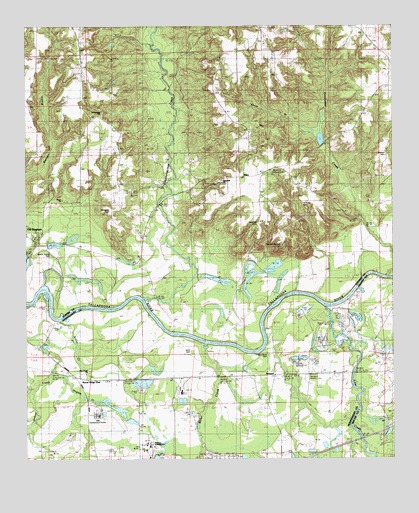
Brassell, AL USGS Topographic Map
Click on map above to begin viewing in our Map Viewer.

This topographic map contains these locations and features:
Feature Name Type Latitude Longitude GNIS ID View Map
Alabama Industrial SchoolSchoolN32.3804°W86.0819°112957View Map
Anthony CemeteryCemeteryN32.4490°W86.0308°113098View Map
Bethany ChurchChurchN32.4604°W86.0500°137141View Map
Billingslea CemeteryCemeteryN32.4465°W86.0961°114343View Map
BrassellPopulated PlaceN32.3996°W86.0402°114852View Map
Carters CreekStreamN32.4124°W86.0441°147750View Map
Cathmagby ChurchChurchN32.4718°W86.1000°137158View Map
Cathmagby SchoolSchoolN32.4704°W86.1000°115705View Map
Chubbehatchee CreekStreamN32.4210°W86.0855°155030View Map
Dawson Bradford CemeteryCemeteryN32.4368°W86.0380°117147View Map
Emerald Mountain AirportAirportN32.4548°W86.1201°2676338View Map
Emerald Mountain Census Designated PlaceCensusN32.4396°W86.0858°2582673View Map
Emerald Mountain Volunteer Fire DepartmentBuildingN32.4699°W86.1051°2691194View Map
Fusihatchi (historical)Populated PlaceN32.4246°W86.1236°158171View Map
Goodwater CreekStreamN32.4274°W86.0030°151796View Map
Hickory Bend CemeteryCemeteryN32.4065°W86.0433°120017View Map
Hoithlewalli (historical)LocaleN32.4196°W86.0805°158143View Map
Jenkins CreekStreamN32.4204°W86.1230°142638View Map
Kilby Correctional FacilityBuildingN32.3880°W86.1011°142647View Map
Line CreekStreamN32.4182°W86.0230°152075View Map
Miller CreekStreamN32.4082°W86.0633°155152View Map
Mount Meigs Medical and Diagnostic CenterHospitalN32.3810°W86.1022°142733View Map
Mount Meigs StationPopulated PlaceN32.3993°W86.1069°123244View Map
New Hope ChurchChurchN32.3996°W86.1050°142748View Map
Peace ChurchChurchN32.4496°W86.1189°124540View Map
Peace School (historical)SchoolN32.4501°W86.1166°137285View Map
Peter Hill CemeteryCemeteryN32.4426°W86.0458°124635View Map
Poundstone DamDamN32.4351°W86.1166°130573View Map
Poundstone LakeReservoirN32.4370°W86.1154°130574View Map
Redland ChurchChurchN32.4915°W86.1211°155408View Map
Rehoboth ChurchChurchN32.4554°W86.0580°125551View Map
Rosenwald School (historical)SchoolN32.4551°W86.0608°137308View Map
Saint Johns ChurchChurchN32.3982°W86.0419°142839View Map
Scott CemeteryCemeteryN32.4060°W86.0688°126480View Map
Sharp BranchStreamN32.4687°W86.0250°126633View Map
Strahan CemeteryCemeteryN32.4629°W86.0027°127448View Map
Tysonville Ferry (historical)CrossingN32.4285°W86.0088°137343View Map
WarePopulated PlaceN32.4565°W86.0508°153889View Map
Ware Ferry (historical)CrossingN32.4340°W86.1247°150038View Map
Wares Quarter CemeteryCemeteryN32.4343°W86.1161°128578View Map

Note: Coordinates in the location and feature list above are referenced to NAD83 datum.


Copyright (C) 2008-2025 Ryan Niemi / Sunset Dynamics ... All Rights Reserved