TopoQuest Logo
Do you find TopoQuest useful?
Help keep TopoQuest running and adding new maps/features by donating!
Bitcoin:  19c7KJd3qBynnjoSw5npx9KScwjBe4ifkT
Litecoin:  LXs6TkuXGGXo1vDsWCkWVdjQX94eUKd6ui
Home View Maps Find Maps Find Places Resources & Links


Bloomfield, Ohio Topographic Map

USGS Map Title: Bloomfield, OH
USGS Map MRC: 40081A6
DRG (GeoTIFF) Download: o40081a6.tif


Neighboring USGS Topographic Map Quads:


  Wills Creek, OH  
40081B7
 

  Plainfield, OH  
40081B6
 

  Kimbolton, OH  
40081B5
 

  Otsego, OH  
40081A7
 

  Bloomfield, OH  
40081A6
 

  Cambridge, OH  
40081A5
 

  Norwich, OH  
39081H7
 

  New Concord, OH  
39081H6
 

  Byesville, OH  
39081H5


Map MRC Location:

N41°
W82°
N41°
W81°
H8 H7 H6 H5 H4 H3 H2 H1
G8 G7 G6 G5 G4 G3 G2 G1
F8 F7 F6 F5 F4 F3 F2 F1
E8 E7 E6 E5 E4 E3 E2 E1
D8 D7 D6 D5 D4 D3 D2 D1
C8 C7 C6 C5 C4 C3 C2 C1
B8 B7 B6 B5 B4 B3 B2 B1
A8 A7 A6 A5 A4 A3 A2 A1
N40°
W82°
N40°
W81°

Bloomfield, OH USGS 1:24K Topographic Map Preview:
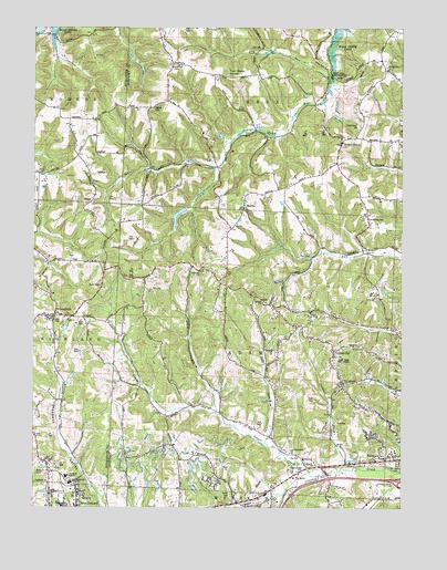
Bloomfield, OH USGS Topographic Map
Click on map above to begin viewing in our Map Viewer.

This topographic map contains these locations and features:
Feature Name Type Latitude Longitude GNIS ID View Map
Berean ChurchChurchN40.0537°W81.6718°1080413View Map
BloomfieldPopulated PlaceN40.0504°W81.7423°1064452View Map
Bloomfield CemeteryCemeteryN40.0492°W81.7382°1964159View Map
Bloomfield Elementary School (historical)SchoolN40.0498°W81.7401°1069039View Map
Bloomfield Lookout Tower (historical)TowerN40.0862°W81.7385°1080421View Map
Bloomfield United Presbyterian ChurchChurchN40.0495°W81.7393°1069041View Map
Bobs RunStreamN40.0170°W81.6704°1038165View Map
BodenPopulated PlaceN40.1151°W81.7023°1048530View Map
Boden Church (historical)ChurchN40.1151°W81.7026°1054653View Map
Boden Post Office (historical)Post OfficeN40.1153°W81.7026°1988769View Map
Carruthers Trailer ParkPopulated PlaceN40.0025°W81.6825°2652205View Map
CassellPopulated PlaceN40.0104°W81.6568°1065516View Map
Cassell Station (historical)LocaleN40.0076°W81.6596°1065515View Map
Cassell Station Volunteer Fire DepartmentBuildingN40.0132°W81.6597°2550195View Map
CassellviewPopulated PlaceN40.0006°W81.6685°1082323View Map
College HillPopulated PlaceN40.0409°W81.6476°1048613View Map
Dry RunStreamN40.1126°W81.6487°1039820View Map
East Muskingum Middle SchoolSchoolN40.0065°W81.7371°1054548View Map
Ford CemeteryCemeteryN40.0415°W81.6384°1040547View Map
Friendship ChurchChurchN40.0065°W81.7449°1080409View Map
Granite Knob School (historical)SchoolN40.0979°W81.7365°1054550View Map
Grove ParkParkN40.0484°W81.7404°1080412View Map
Hawthorne CemeteryCemeteryN40.1040°W81.7093°1041415View Map
Hopewell Methodist Episcopal CemeteryCemeteryN40.0967°W81.6451°1963726View Map
Indian CampPopulated PlaceN40.0945°W81.6457°1048862View Map
Indian Camp BridgeBridgeN40.1128°W81.6490°1054652View Map
Indian Camp Post Office (historical)Post OfficeN40.0945°W81.6457°1988924View Map
Indian School (historical)SchoolN40.0878°W81.6868°1054654View Map
Jackson RunStreamN40.0109°W81.6396°1042037View Map
John H Glenn High SchoolSchoolN40.0084°W81.7387°1042109View Map
Lebanon CemeteryCemeteryN40.0615°W81.6940°1963728View Map
Lebanon ChurchChurchN40.0617°W81.6932°1042465View Map
Lebanon School (historical)SchoolN40.0640°W81.6996°1054655View Map
MantuaPopulated PlaceN40.0778°W81.6790°1080453View Map
McCorkle College (historical)SchoolN40.0498°W81.7401°1069059View Map
McNeals CemeteryCemeteryN40.1033°W81.7412°1964172View Map
Morrow CemeteryCemeteryN40.1040°W81.7096°1080415View Map
Mount Calvary CemeteryCemeteryN40.0117°W81.6260°1080411View Map
Mount Herman CemeteryCemeteryN40.1134°W81.6301°1963732View Map
Mount Herman ChurchChurchN40.1140°W81.6296°1043566View Map
Northfield CemeteryCemeteryN40.1148°W81.7035°1080416View Map
Peters CreekStreamN40.0084°W81.6526°1044402View Map
Peters Creek School (historical)SchoolN40.0229°W81.6998°1054656View Map
Pike SchoolSchoolN40.0131°W81.6573°1044442View Map
Pleasant ValleyValleyN40.0054°W81.7290°1044587View Map
Ridgewood AcresPopulated PlaceN40.0190°W81.6343°1054651View Map
Sarchet Run CemeteryCemeteryN40.0753°W81.6366°1082186View Map
Sarchett Run School (historical)SchoolN40.0681°W81.6512°1082322View Map
South Bridge ParkParkN40.0104°W81.6573°1080410View Map
Stony Point School (historical)SchoolN40.0642°W81.7448°1054549View Map
Township of AdamsCivilN40.0407°W81.6755°1086177View Map
Township of KnoxCivilN40.1142°W81.6718°1086182View Map
Twin Sister KnobsSummitN40.1134°W81.6843°1049255View Map
Valley View VillagePopulated PlaceN40.0022°W81.6817°2652210View Map
WCMJ-FM (Cambridge)TowerN40.0401°W81.6471°1085323View Map
WILE-AM (Cambridge)TowerN40.0401°W81.6471°1085257View Map
WILE-WGMS Radio TowerTowerN40.0395°W81.6448°1080414View Map

Note: Coordinates in the location and feature list above are referenced to NAD83 datum.


Copyright (C) 2008-2024 Ryan Niemi / Sunset Dynamics ... All Rights Reserved