TopoQuest Logo
Do you find TopoQuest useful?
Help keep TopoQuest running and adding new maps/features by donating!
Bitcoin:  19c7KJd3qBynnjoSw5npx9KScwjBe4ifkT
Litecoin:  LXs6TkuXGGXo1vDsWCkWVdjQX94eUKd6ui
Home View Maps Find Maps Find Places Resources & Links


Tampico, Illinois Topographic Map

USGS Map Title: Tampico, IL
USGS Map MRC: 41089F7
DRG (GeoTIFF) Download: o41089f7.tif


Neighboring USGS Topographic Map Quads:


  Morrison, IL  
41089G8
 

  Como, IL  
41089G7
 

  Sterling, IL  
41089G6
 

  Prophetstown, IL  
41089F8
 

  Tampico, IL  
41089F7
 

  Hahnaman, IL  
41089F6
 

  Hooppole, IL  
41089E8
 

  Yorktown, IL  
41089E7
 

  New Bedford, IL  
41089E6


Map MRC Location:

N42°
W90°
N42°
W89°
H8 H7 H6 H5 H4 H3 H2 H1
G8 G7 G6 G5 G4 G3 G2 G1
F8 F7 F6 F5 F4 F3 F2 F1
E8 E7 E6 E5 E4 E3 E2 E1
D8 D7 D6 D5 D4 D3 D2 D1
C8 C7 C6 C5 C4 C3 C2 C1
B8 B7 B6 B5 B4 B3 B2 B1
A8 A7 A6 A5 A4 A3 A2 A1
N41°
W90°
N41°
W89°

Tampico, IL USGS 1:24K Topographic Map Preview:
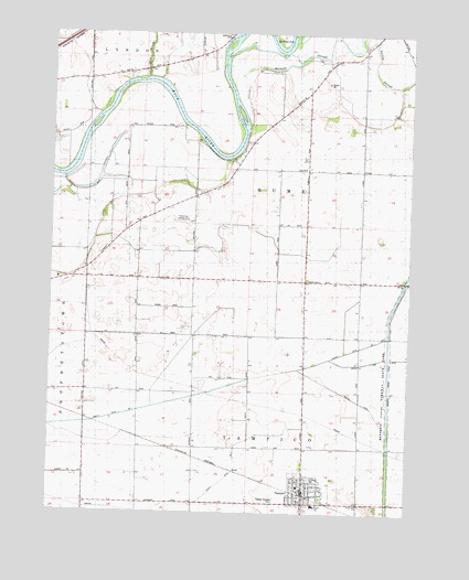
Tampico, IL USGS Topographic Map
Click on map above to begin viewing in our Map Viewer.

This topographic map contains these locations and features:
Feature Name Type Latitude Longitude GNIS ID View Map
Church of ChristChurchN41.6298°W89.7832°1968076View Map
County Ditch Number 1CanalN41.6573°W89.8173°424780View Map
Deer CreekStreamN41.7384°W89.8432°407070View Map
Highland School (historical)SchoolN41.6564°W89.8484°410231View Map
Hume Center School (historical)SchoolN41.7153°W89.7834°410681View Map
Main Street Historic DistrictParkN41.6306°W89.7859°1824056View Map
Maple Hill School (historical)SchoolN41.6278°W89.7665°412957View Map
North Hume School (historical)SchoolN41.7336°W89.7896°414619View Map
Old Hume CemeteryCemeteryN41.6859°W89.7816°1718899View Map
Olson School (historical)SchoolN41.6525°W89.8057°415111View Map
Prophet PitMineN41.7358°W89.7803°2712319View Map
Ramsey SloughStreamN41.7370°W89.8137°416374View Map
Rutherford Landing Strip (historical)AirportN41.7009°W89.8293°1718900View Map
Saint Marys CemeteryCemeteryN41.6342°W89.7840°1718897View Map
Saint Marys ChurchChurchN41.6320°W89.7843°1968077View Map
South Hume School (historical)SchoolN41.6853°W89.7873°418789View Map
TampicoPopulated PlaceN41.6303°W89.7862°419533View Map
Tampico Baptist ChurchChurchN41.6336°W89.7884°1968078View Map
Tampico Elementary SchoolSchoolN41.6320°W89.7876°1824116View Map
Tampico High SchoolSchoolN41.6273°W89.7823°1718898View Map
Tampico Post OfficePost OfficeN41.6320°W89.7857°2788337View Map
Tampico Rural Fire Protection DistrictBuildingN41.6316°W89.7856°2640545View Map
The Bend School (historical)SchoolN41.7425°W89.8351°419626View Map
Township of HumeCivilN41.7096°W89.7996°429154View Map
Township of TampicoCivilN41.6277°W89.8050°429824View Map
Village of TampicoCivilN41.6307°W89.7854°2399952View Map
West Hume School (historical)SchoolN41.7009°W89.8454°420856View Map
William L Rutherford Airport (historical)AirportN41.7014°W89.8290°427713View Map

Note: Coordinates in the location and feature list above are referenced to NAD83 datum.


Copyright (C) 2008-2025 Ryan Niemi / Sunset Dynamics ... All Rights Reserved