TopoQuest Logo
Do you find TopoQuest useful?
Help keep TopoQuest running and adding new maps/features by donating!
Bitcoin:  19c7KJd3qBynnjoSw5npx9KScwjBe4ifkT
Litecoin:  LXs6TkuXGGXo1vDsWCkWVdjQX94eUKd6ui
Home View Maps Find Maps Find Places Resources & Links


New Bedford, Illinois Topographic Map

USGS Map Title: New Bedford, IL
USGS Map MRC: 41089E6
DRG (GeoTIFF) Download: o41089e6.tif


Neighboring USGS Topographic Map Quads:


  Tampico, IL  
41089F7
 

  Hahnaman, IL  
41089F6
 

  Harmon, IL  
41089F5
 

  Yorktown, IL  
41089E7
 

  New Bedford, IL  
41089E6
 

  Walnut, IL  
41089E5
 

  Mineral, IL  
41089D7
 

  Manlius, IL  
41089D6
 

  Buda NE, IL  
41089D5


Map MRC Location:

N42°
W90°
N42°
W89°
H8 H7 H6 H5 H4 H3 H2 H1
G8 G7 G6 G5 G4 G3 G2 G1
F8 F7 F6 F5 F4 F3 F2 F1
E8 E7 E6 E5 E4 E3 E2 E1
D8 D7 D6 D5 D4 D3 D2 D1
C8 C7 C6 C5 C4 C3 C2 C1
B8 B7 B6 B5 B4 B3 B2 B1
A8 A7 A6 A5 A4 A3 A2 A1
N41°
W90°
N41°
W89°

New Bedford, IL USGS 1:24K Topographic Map Preview:
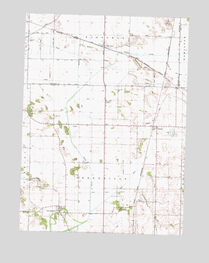
New Bedford, IL USGS Topographic Map
Click on map above to begin viewing in our Map Viewer.

This topographic map contains these locations and features:
Feature Name Type Latitude Longitude GNIS ID View Map
Allen CreekStreamN41.5356°W89.6632°403424View Map
Baker Creek DitchCanalN41.5773°W89.6976°403827View Map
Bowen CemeteryCemeteryN41.5192°W89.6573°404726View Map
Bowen School (historical)SchoolN41.5195°W89.6457°404729View Map
Church School (historical)SchoolN41.5400°W89.7162°406117View Map
Crooked CreekStreamN41.5275°W89.6709°422179View Map
Deer GrovePopulated PlaceN41.6078°W89.6895°407074View Map
Deer Grove (historical)WoodsN41.5984°W89.6590°1824003View Map
Deer Grove Post OfficePost OfficeN41.6076°W89.6898°2788199View Map
Fairfield CemeteryCemeteryN41.5300°W89.7423°408168View Map
Geldean AirportAirportN41.5129°W89.6290°2717718View Map
Hahnaman Elementary SchoolSchoolN41.6078°W89.6893°1824035View Map
Little Deer Grove (historical)WoodsN41.6089°W89.6798°1824052View Map
Maple Grove School (historical)SchoolN41.5881°W89.6495°412951View Map
Meek School (historical)SchoolN41.5584°W89.6873°413368View Map
New BedfordPopulated PlaceN41.5128°W89.7207°414379View Map
New Bedford Post OfficePost OfficeN41.5136°W89.7203°2788381View Map
NormandyPopulated PlaceN41.5620°W89.6493°414550View Map
Normandy DitchCanalN41.5789°W89.6293°414551View Map
Normandy Post OfficePost OfficeN41.5625°W89.6509°1820569View Map
Reeves School (historical)SchoolN41.6217°W89.7273°416507View Map
Sunset Ridge Emergency Medical ServicesBuildingN41.5049°W89.6462°2673890View Map
Swanson SchoolSchoolN41.5673°W89.7432°419466View Map
Township of GreenvilleCivilN41.5408°W89.6857°429081View Map
Village of Deer GroveCivilN41.6098°W89.6874°2398703View Map
Village of New BedfordCivilN41.5112°W89.7184°2399455View Map
Walnut CreekStreamN41.5114°W89.6970°420446View Map
Walnut Special DitchCanalN41.5389°W89.6590°420483View Map
White School (historical)SchoolN41.5006°W89.6815°421078View Map
Woodley 2 AirportAirportN41.5197°W89.6561°2717719View Map
Woodley Aerial Spray Airport (historical)AirportN41.5359°W89.7011°2679069View Map

Note: Coordinates in the location and feature list above are referenced to NAD83 datum.


Copyright (C) 2008-2024 Ryan Niemi / Sunset Dynamics ... All Rights Reserved