TopoQuest Logo
Do you find TopoQuest useful?
Help keep TopoQuest running and adding new maps/features by donating!
Bitcoin:  19c7KJd3qBynnjoSw5npx9KScwjBe4ifkT
Litecoin:  LXs6TkuXGGXo1vDsWCkWVdjQX94eUKd6ui
Home View Maps Find Maps Find Places Resources & Links


Cliff Lake, Montana Topographic Map

USGS Map Title: Cliff Lake, MT
USGS Map MRC: 44111G5
DRG (GeoTIFF) Download: o44111g5.tif


Neighboring USGS Topographic Map Quads:


  Granite Mountain, MT  
44111H6
 

  Bad Luck Creek, MT  
44111H5
 

  Hilgard Peak, MT  
44111H4
 

  Freezeout Mountain, MT  
44111G6
 

  Cliff Lake, MT  
44111G5
 

  Earthquake Lake, MT  
44111G4
 

  Elk Springs, MT  
44111F6
 

  Hidden Lake Bench, MT  
44111F5
 

  Targhee Peak, ID  
44111F4


Map MRC Location:

N45°
W112°
N45°
W111°
H8 H7 H6 H5 H4 H3 H2 H1
G8 G7 G6 G5 G4 G3 G2 G1
F8 F7 F6 F5 F4 F3 F2 F1
E8 E7 E6 E5 E4 E3 E2 E1
D8 D7 D6 D5 D4 D3 D2 D1
C8 C7 C6 C5 C4 C3 C2 C1
B8 B7 B6 B5 B4 B3 B2 B1
A8 A7 A6 A5 A4 A3 A2 A1
N44°
W112°
N44°
W111°

Cliff Lake, MT USGS 1:24K Topographic Map Preview:
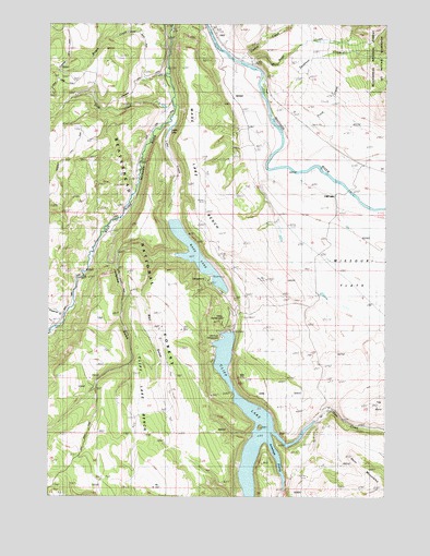
Cliff Lake, MT USGS Topographic Map
Click on map above to begin viewing in our Map Viewer.

This topographic map contains these locations and features:
Feature Name Type Latitude Longitude GNIS ID View Map
11S01E13DBC_01 SpringSpringN44.8721°W111.5458°807228View Map
11S01E24DBD_01 SpringSpringN44.8583°W111.5450°807225View Map
11S02E30BDCD01 WellWellN44.8466°W111.5319°807222View Map
11S02E32DCDC01 SpringSpringN44.8258°W111.5066°807219View Map
12S01E11ADD_01 SpringSpringN44.8038°W111.5594°807214View Map
Antelope ProngBayN44.7638°W111.5439°778784View Map
Bogus CreekStreamN44.8694°W111.5886°780192View Map
Butte CreekStreamN44.8635°W111.5502°780693View Map
Cliff LakePopulated PlaceN44.8296°W111.5197°806929View Map
Cliff LakeLakeN44.7653°W111.5469°781390View Map
Cliff Lake BenchBenchN44.7755°W111.5900°781391View Map
Cliff Lake Post Office (historical)Post OfficeN44.8296°W111.5197°1797555View Map
Cliff Lake School (historical)SchoolN44.8296°W111.5197°1797556View Map
Cliff Point CampgroundLocaleN44.7919°W111.5619°781392View Map
Curlew CreekStreamN44.8652°W111.5541°781991View Map
Deadman CreekStreamN44.8649°W111.5397°782153View Map
Elliots ResortLocaleN44.8035°W111.5614°783147View Map
Freezeout CreekStreamN44.7980°W111.6200°783722View Map
Grahams PlacePopulated PlaceN44.8588°W111.5841°806950View Map
Hilltop CampgroundLocaleN44.7971°W111.5605°793666View Map
Horn CreekStreamN44.7666°W111.5422°785015View Map
Jackpine GulchValleyN44.8135°W111.5772°785381View Map
Lake CreekStreamN44.8513°W111.5791°785899View Map
Madison River LodgeLocaleN44.8566°W111.5444°786770View Map
Madison Valley Rural Fire Department Station 2BuildingN44.8491°W111.5328°2546487View Map
Missouri FlatsFlatN44.8060°W111.5075°787511View Map
Missouri Flats (historical)Populated PlaceN44.8027°W111.5258°1797479View Map
Neelys CampLocaleN44.7710°W111.5244°787930View Map
Pine Butte LodgeLocaleN44.8658°W111.5508°788872View Map
Schusters PlacePopulated PlaceN44.8741°W111.5452°806971View Map
Smith LakeLakeN44.8472°W111.5807°790728View Map
Soap CreekStreamN44.8544°W111.5797°790824View Map
Trout CreekStreamN44.8544°W111.5444°792393View Map
Wade LakeLakeN44.8139°W111.5712°793672View Map
Wade Lake BenchBenchN44.8508°W111.5700°792740View Map
Wade Lake Camp GroundsLocaleN44.8083°W111.5689°792741View Map
Well GulchValleyN44.8116°W111.5877°792934View Map
Wickadahl RanchLocaleN44.8083°W111.5694°793261View Map

Note: Coordinates in the location and feature list above are referenced to NAD83 datum.


Copyright (C) 2008-2025 Ryan Niemi / Sunset Dynamics ... All Rights Reserved