TopoQuest Logo
Do you find TopoQuest useful?
Help keep TopoQuest running and adding new maps/features by donating!
Bitcoin:  19c7KJd3qBynnjoSw5npx9KScwjBe4ifkT
Litecoin:  LXs6TkuXGGXo1vDsWCkWVdjQX94eUKd6ui
Home View Maps Find Maps Find Places Resources & Links


Winona, West Virginia Topographic Map

USGS Map Title: Winona, WV
USGS Map MRC: 38080A8
DRG (GeoTIFF) Download: o38080a8.tif


Neighboring USGS Topographic Map Quads:


  Ansted, WV  
38081B1
 

  Summersville Dam, WV  
38080B8
 

  Mount Nebo, WV  
38080B7
 

  Fayetteville, WV  
38081A1
 

  Winona, WV  
38080A8
 

  Corliss, WV  
38080A7
 

  Thurmond, WV  
37081H1
 

  Danese, WV  
37080H8
 

  Rainelle, WV  
37080H7


Map MRC Location:

N39°
W81°
N39°
W80°
H8 H7 H6 H5 H4 H3 H2 H1
G8 G7 G6 G5 G4 G3 G2 G1
F8 F7 F6 F5 F4 F3 F2 F1
E8 E7 E6 E5 E4 E3 E2 E1
D8 D7 D6 D5 D4 D3 D2 D1
C8 C7 C6 C5 C4 C3 C2 C1
B8 B7 B6 B5 B4 B3 B2 B1
A8 A7 A6 A5 A4 A3 A2 A1
N38°
W81°
N38°
W80°

Winona, WV USGS 1:24K Topographic Map Preview:
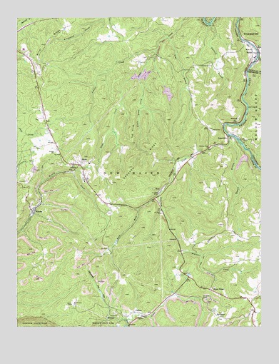
Winona, WV USGS Topographic Map
Click on map above to begin viewing in our Map Viewer.

This topographic map contains these locations and features:
Feature Name Type Latitude Longitude GNIS ID View Map
Amick CemeteryCemeteryN38.0068°W80.9007°1534920View Map
BabcockPopulated PlaceN38.0826°W80.8884°1549575View Map
Bays ChapelChurchN38.1123°W80.8759°1535328View Map
Bays School (historical)SchoolN38.1126°W80.8762°1741261View Map
Betty Bell KnobSummitN38.0646°W80.8964°1556053View Map
Brackens CreekStreamN38.0773°W80.8918°1536280View Map
Brackens Creek ChurchChurchN38.0726°W80.9015°1536281View Map
Chesnut Grove School (historical)SchoolN38.1046°W80.9112°1556064View Map
Chestnut Grove ChurchChurchN38.1057°W80.9068°1537275View Map
ClifftopPopulated PlaceN38.0043°W80.9440°1554149View Map
Crooked RidgeRidgeN38.0581°W80.9458°1537842View Map
DividePopulated PlaceN38.0668°W80.9662°1554308View Map
Divide Elementary SchoolSchoolN38.0660°W80.9629°1556074View Map
Dubree (historical)Populated PlaceN38.0526°W80.9876°1556222View Map
Fallrock BranchStreamN38.1223°W80.9020°1538869View Map
Flannigan School (historical)SchoolN38.0248°W80.9937°1556102View Map
Floyd CreekStreamN38.0029°W80.9448°1539101View Map
Haynes BranchStreamN38.0690°W80.8798°1556297View Map
Haynes BranchStreamN38.0740°W80.8918°1540091View Map
Haynes School (historical)SchoolN38.1026°W80.8829°1556117View Map
Hilton VillagePopulated PlaceN38.0151°W80.9015°1554720View Map
Hogpen RidgeRidgeN38.0425°W80.9157°1556121View Map
Jennette CemeteryCemeteryN38.0709°W80.9804°1540862View Map
Laurel CreekStreamN38.1118°W80.9301°1541403View Map
Little Glade CreekStreamN38.1007°W80.9382°1542106View Map
LookoutPopulated PlaceN38.0654°W80.9684°1554994View Map
Lookout Census Designated PlaceCensusN38.0664°W80.9647°2586848View Map
Lookout Post OfficePost OfficeN38.0579°W80.9634°2774641View Map
MedoPopulated PlaceN38.0554°W80.9270°1555102View Map
Midland Trail High SchoolSchoolN38.1122°W80.9962°1556145View Map
Miller ChurchChurchN38.1121°W80.8801°1543378View Map
Miller RidgeRidgeN38.1108°W80.9899°1543390View Map
NallenPopulated PlaceN38.1107°W80.8770°1555187View Map
Nallen BridgeBridgeN38.1072°W80.8780°2647549View Map
Nallen Post OfficePost OfficeN38.1065°W80.8799°2774638View Map
New Haven DistrictCivilN38.0110°W80.9690°1928319View Map
Nuttall Middle SchoolSchoolN38.0587°W80.9654°1556161View Map
Nuttall Volunteer Fire DepartmentBuildingN38.0976°W80.9885°2577866View Map
Old Stone HouseBuildingN38.0118°W80.9048°1544373View Map
Pleasant Hill School (historical)SchoolN38.0440°W80.8757°1556176View Map
Prosperity School (historical)SchoolN38.0509°W80.8920°1556182View Map
RavenseyePopulated PlaceN38.0040°W80.8959°1549891View Map
Road ForkStreamN38.0532°W80.9273°1545803View Map
RussellvillePopulated PlaceN38.0765°W80.8923°1546192View Map
Russelville BridgeBridgeN38.0776°W80.8914°2646947View Map
Shawver School (historical)SchoolN38.1196°W80.9337°1556197View Map
Shelton School (historical)SchoolN38.0290°W80.9151°1556198View Map
Spring CreekStreamN38.0884°W80.8820°1547185View Map
Spy RockPopulated PlaceN38.0701°W80.9776°1556202View Map
Spy RockPillarN38.0698°W80.9782°1547290View Map
The DivideRidgeN38.0743°W80.9410°1548000View Map
Toms BranchStreamN38.1171°W80.9223°1548131View Map
Trace RidgeRidgeN38.0412°W80.8950°1556207View Map
Tyree CemeteryCemeteryN38.0101°W80.9029°1548453View Map
West Virginia State College 4-H CampLocaleN38.0098°W80.9704°1556214View Map
WinonaPopulated PlaceN38.0465°W80.9923°1556011View Map
Winona Census Designated PlaceCensusN38.0466°W80.9938°2586902View Map
Withrows Mill (historical)LocaleN38.0923°W80.9107°1556217View Map
Youngs CreekStreamN38.1084°W80.8768°1549472View Map

Note: Coordinates in the location and feature list above are referenced to NAD83 datum.


Copyright (C) 2008-2024 Ryan Niemi / Sunset Dynamics ... All Rights Reserved