TopoQuest Logo
Do you find TopoQuest useful?
Help keep TopoQuest running and adding new maps/features by donating!
Bitcoin:  19c7KJd3qBynnjoSw5npx9KScwjBe4ifkT
Litecoin:  LXs6TkuXGGXo1vDsWCkWVdjQX94eUKd6ui
Home View Maps Find Maps Find Places Resources & Links


Washington West, Georgia Topographic Map

USGS Map Title: Washington West, GA
USGS Map MRC: 33082F7
DRG (GeoTIFF) Download: o33082f7.tif


Neighboring USGS Topographic Map Quads:


  Rayle, GA  
33082G8
 

  Celeste, GA  
33082G7
 

  Tignall, GA  
33082G6
 

  Philomath, GA  
33082F8
 

  Washington West, GA  
33082F7
 

  Washington East, GA  
33082F6
 

  Crawfordville, GA  
33082E8
 

  Sharon, GA  
33082E7
 

  Cadley, GA  
33082E6


Map MRC Location:

N34°
W83°
N34°
W82°
H8 H7 H6 H5 H4 H3 H2 H1
G8 G7 G6 G5 G4 G3 G2 G1
F8 F7 F6 F5 F4 F3 F2 F1
E8 E7 E6 E5 E4 E3 E2 E1
D8 D7 D6 D5 D4 D3 D2 D1
C8 C7 C6 C5 C4 C3 C2 C1
B8 B7 B6 B5 B4 B3 B2 B1
A8 A7 A6 A5 A4 A3 A2 A1
N33°
W83°
N33°
W82°

Washington West, GA USGS 1:24K Topographic Map Preview:
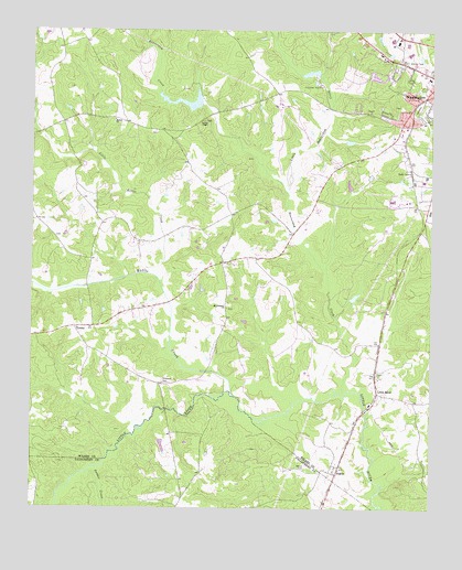
Washington West, GA USGS Topographic Map
Click on map above to begin viewing in our Map Viewer.

This topographic map contains these locations and features:
Feature Name Type Latitude Longitude GNIS ID View Map
Beaverdam CreekStreamN33.6557°W82.7776°311006View Map
Beaverdam Creek DamDamN33.7301°W82.8232°339471View Map
Beaverdam Creek LakeReservoirN33.7314°W82.8268°339472View Map
Bethel CemeteryCemeteryN33.7260°W82.8493°342738View Map
Bethel ChurchChurchN33.7265°W82.8490°354614View Map
Burdette-Harris Dam Number OneDamN33.7085°W82.7765°338784View Map
Burdette-Harris Lake Number OneReservoirN33.7097°W82.7757°338785View Map
City of Washington ReservoirReservoirN33.7367°W82.7866°339470View Map
City of Washington Reservoir DamDamN33.7368°W82.7849°339469View Map
Edwards LakeReservoirN33.6414°W82.8339°339502View Map
Edwards Lake DamDamN33.6418°W82.8349°339501View Map
FicklinPopulated PlaceN33.6343°W82.7793°331705View Map
Georgia State Patrol Troop E Post 17 WashingtonBuildingN33.7224°W82.7620°2733982View Map
Harden CreekStreamN33.6257°W82.7665°315117View Map
Harris-Burdette Dam TwoDamN33.7085°W82.7699°338782View Map
Harris-Burdette Lake TwoReservoirN33.7085°W82.7699°338783View Map
Jackson Chapel African Methodist Episcopal ChurchChurchN33.7312°W82.7554°342765View Map
Kettle CreekStreamN33.6546°W82.8115°316400View Map
Lina (historical)Populated PlaceN33.7262°W82.8654°342770View Map
Lincoln HeightsPopulated PlaceN33.7301°W82.7749°342771View Map
Little Beaverdam CreekStreamN33.7071°W82.7949°316944View Map
Little Kettle CreekStreamN33.6857°W82.8354°317108View Map
Little RiverPopulated PlaceN33.6554°W82.7668°332244View Map
Mercer CemeteryCemeteryN33.6357°W82.7887°318034View Map
Mount Pleasant ChurchChurchN33.6774°W82.8138°318858View Map
Palmer LakeReservoirN33.6808°W82.7735°339468View Map
Palmer Lake DamDamN33.6801°W82.7749°339467View Map
Popes Chapel African Methodist Episcopal Church (historical)ChurchN33.7424°W82.7604°342785View Map
Powder CreekStreamN33.6343°W82.8571°321104View Map
Ranger StadiumParkN33.7368°W82.7513°342789View Map
Simpson CemeteryCemeteryN33.6581°W82.8337°323019View Map
Stony Ridge MineMineN33.6965°W82.8132°342799View Map
Stony Ridge School (historical)SchoolN33.7007°W82.8124°342800View Map
Tabernacle Baptist ChurchChurchN33.7415°W82.7582°342802View Map
TyronePopulated PlaceN33.6724°W82.8613°333295View Map
Tyrone Volunteer Fire DepartmentBuildingN33.6714°W82.8653°2604007View Map
Washington HeightsPopulated PlaceN33.7382°W82.7657°342812View Map
Wilkes AcademySchoolN33.7376°W82.7507°342820View Map
Wilson Chapel Presbyterian ChurchChurchN33.7329°W82.7540°342824View Map
Youngs ChapelChurchN33.7262°W82.8213°325645View Map

Note: Coordinates in the location and feature list above are referenced to NAD83 datum.


Copyright (C) 2008-2025 Ryan Niemi / Sunset Dynamics ... All Rights Reserved