TopoQuest Logo
Do you find TopoQuest useful?
Help keep TopoQuest running and adding new maps/features by donating!
Bitcoin:  19c7KJd3qBynnjoSw5npx9KScwjBe4ifkT
Litecoin:  LXs6TkuXGGXo1vDsWCkWVdjQX94eUKd6ui
Home View Maps Find Maps Find Places Resources & Links


Tomnolen, Mississippi Topographic Map

USGS Map Title: Tomnolen, MS
USGS Map MRC: 33089D3
DRG (GeoTIFF) Download: o33089d3.tif


Neighboring USGS Topographic Map Quads:


  Little Sand Creek, MS  
33089E4
 

  Eupora, MS  
33089E3
 

  Sapa, MS  
33089E2
 

  Stewart, MS  
33089D4
 

  Tomnolen, MS  
33089D3
 

  Reform, MS  
33089D2
 

  French Camp, MS  
33089C4
 

  Weir, MS  
33089C3
 

  Ackerman, MS  
33089C2


Map MRC Location:

N34°
W90°
N34°
W89°
H8 H7 H6 H5 H4 H3 H2 H1
G8 G7 G6 G5 G4 G3 G2 G1
F8 F7 F6 F5 F4 F3 F2 F1
E8 E7 E6 E5 E4 E3 E2 E1
D8 D7 D6 D5 D4 D3 D2 D1
C8 C7 C6 C5 C4 C3 C2 C1
B8 B7 B6 B5 B4 B3 B2 B1
A8 A7 A6 A5 A4 A3 A2 A1
N33°
W90°
N33°
W89°

Tomnolen, MS USGS 1:24K Topographic Map Preview:
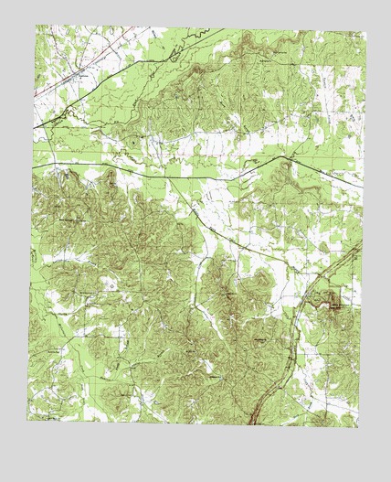
Tomnolen, MS USGS Topographic Map
Click on map above to begin viewing in our Map Viewer.

This topographic map contains these locations and features:
Feature Name Type Latitude Longitude GNIS ID View Map
Ada (historical)LocaleN33.4793°W89.2848°685826View Map
Bankston (historical)LocaleN33.3973°W89.3667°707488View Map
Bankston CemeteryCemeteryN33.3968°W89.3681°666506View Map
Bankston School (historical)SchoolN33.4071°W89.3390°685832View Map
Baptism BranchStreamN33.4243°W89.3740°666509View Map
Big Bywy DitchCanalN33.4526°W89.3287°667091View Map
Blaine Store (historical)LocaleN33.3923°W89.2892°685834View Map
Bluff Spring CemeteryCemeteryN33.4929°W89.2867°667336View Map
Bluff Spring ChurchChurchN33.4904°W89.2876°667337View Map
Bluff Springs School (historical)SchoolN33.4743°W89.3084°685835View Map
Bowie BranchStreamN33.3843°W89.2673°667474View Map
Boyd CreekStreamN33.3893°W89.3528°667494View Map
Boyd School (historical)SchoolN33.4751°W89.2612°685836View Map
Bywy CreekStreamN33.4632°W89.3726°667896View Map
Bywy School (historical)SchoolN33.4310°W89.2592°685838View Map
C E King Lake DamDamN33.3868°W89.3334°682043View Map
Chapel Hill CemeteryCemeteryN33.4157°W89.3012°707496View Map
Chapel Hill ChurchChurchN33.4162°W89.3015°668328View Map
Chapel Hill School (historical)SchoolN33.4065°W89.2987°685842View Map
Clear Springs CemeteryCemeteryN33.4004°W89.2862°707500View Map
Clear Springs ChurchChurchN33.4018°W89.2859°668590View Map
Coxs Store (historical)LocaleN33.4057°W89.3234°685843View Map
Daniels CreekStreamN33.4548°W89.2645°669101View Map
Hamrick CemeteryCemeteryN33.3837°W89.3356°670873View Map
Hamrick CreekStreamN33.3893°W89.3526°670874View Map
Hogan Chapel School (historical)SchoolN33.3893°W89.2620°685856View Map
Jeff Busby ParkParkN33.4162°W89.2623°671820View Map
Jenkins BranchStreamN33.3882°W89.3423°671831View Map
Jenkins CreekStreamN33.4404°W89.3137°671838View Map
Little Bywy CreekStreamN33.4257°W89.2778°693749View Map
Little MountainSummitN33.4137°W89.2609°672648View Map
Log BranchStreamN33.4193°W89.2576°672764View Map
Lolly HillSummitN33.4985°W89.2551°672777View Map
Marshall BranchStreamN33.4898°W89.3281°673161View Map
McCurtain Creek ChurchChurchN33.4157°W89.3503°673326View Map
McCurtin Creek CemeteryCemeteryN33.4162°W89.3495°707514View Map
Middle Bywy CreekStreamN33.4526°W89.3253°673524View Map
Mile BranchStreamN33.4860°W89.3437°673565View Map
Mossy BranchStreamN33.4573°W89.3009°673881View Map
Mount Olive ChurchChurchN33.3979°W89.3123°674148View Map
New Haven ChurchChurchN33.3757°W89.3670°674642View Map
Pilgrims Rest CemeteryCemeteryN33.4290°W89.2534°675767View Map
Pine Bluff School (historical)SchoolN33.4890°W89.2753°685868View Map
Progress School (historical)SchoolN33.4015°W89.2848°685872View Map
Providence CemeteryCemeteryN33.3896°W89.3017°707524View Map
Providence ChurchChurchN33.3901°W89.3023°676387View Map
Reedy BranchStreamN33.3882°W89.3431°676571View Map
Rockport Church (historical)ChurchN33.4140°W89.3251°685877View Map
Saint John Church (historical)ChurchN33.4646°W89.3220°685878View Map
Salt CreekStreamN33.4976°W89.3192°677304View Map
Sheedy BranchStreamN33.4162°W89.3728°677631View Map
Short CanalCanalN33.4679°W89.3601°677740View Map
Simpson Store (historical)LocaleN33.3785°W89.3742°685881View Map
Tanyard BranchStreamN33.4554°W89.2665°678563View Map
TomnolenPopulated PlaceN33.4848°W89.3606°678812View Map
Tomnolen Baptist ChurchChurchN33.4848°W89.3620°682865View Map
Tomnolen Volunteer Fire DepartmentBuildingN33.4873°W89.3577°2665726View Map
Union School (historical)SchoolN33.4385°W89.3498°685884View Map
Watsons Mill (historical)LocaleN33.4015°W89.3542°685886View Map
Watsons Store (historical)LocaleN33.3832°W89.3420°685887View Map
White Mill (historical)LocaleN33.3798°W89.2692°685888View Map
Wood SpringsPopulated PlaceN33.4382°W89.3595°692330View Map
Wood Springs CemeteryCemeteryN33.4390°W89.3584°707533View Map
Wood Springs ChurchChurchN33.4385°W89.3587°679832View Map

Note: Coordinates in the location and feature list above are referenced to NAD83 datum.


Copyright (C) 2008-2025 Ryan Niemi / Sunset Dynamics ... All Rights Reserved