TopoQuest Logo
Do you find TopoQuest useful?
Help keep TopoQuest running and adding new maps/features by donating!
Bitcoin:  19c7KJd3qBynnjoSw5npx9KScwjBe4ifkT
Litecoin:  LXs6TkuXGGXo1vDsWCkWVdjQX94eUKd6ui
Home View Maps Find Maps Find Places Resources & Links


Trempealeau, Wisconsin Topographic Map

USGS Map Title: Trempealeau, WI
USGS Map MRC: 44091A4
DRG (GeoTIFF) Download: o44091a4.tif


Neighboring USGS Topographic Map Quads:


  Dodge, WI  
44091B5
 

  Tamarack, WI  
44091B4
 

  Ettrick, WI  
44091B3
 

  Winona East, MN  
44091A5
 

  Trempealeau, WI  
44091A4
 

  Galesville, WI  
44091A3
 

  Witoka, MN  
43091H5
 

  Pickwick, MN  
43091H4
 

  Holmen, WI  
43091H3


Map MRC Location:

N45°
W92°
N45°
W91°
H8 H7 H6 H5 H4 H3 H2 H1
G8 G7 G6 G5 G4 G3 G2 G1
F8 F7 F6 F5 F4 F3 F2 F1
E8 E7 E6 E5 E4 E3 E2 E1
D8 D7 D6 D5 D4 D3 D2 D1
C8 C7 C6 C5 C4 C3 C2 C1
B8 B7 B6 B5 B4 B3 B2 B1
A8 A7 A6 A5 A4 A3 A2 A1
N44°
W92°
N44°
W91°

Trempealeau, WI USGS 1:24K Topographic Map Preview:
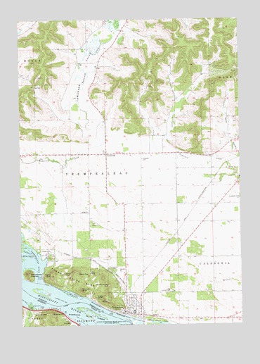
Trempealeau, WI USGS Topographic Map
Click on map above to begin viewing in our Map Viewer.

This topographic map contains these locations and features:
Feature Name Type Latitude Longitude GNIS ID View Map
Bald KnobSummitN44.0208°W91.4585°1561121View Map
Bartle School (historical)SchoolN44.1075°W91.4607°1851060View Map
Brady's Bluff Prairie State Natural AreaParkN44.0200°W91.4851°2061780View Map
Bradys BluffSummitN44.0202°W91.4832°1562134View Map
Bunnels BluffSummitN44.0144°W91.4663°1562411View Map
Carhart Farms AirportAirportN44.0516°W91.3778°1581987View Map
Cedar CreekStreamN44.0097°W91.4951°640997View Map
Cedar Valley Golf CourseLocaleN44.0014°W91.4974°2052068View Map
CentervillePopulated PlaceN44.0700°W91.4513°1562894View Map
Centerville Methodist ChurchChurchN44.0697°W91.4615°1851077View Map
Centerville School (historical)SchoolN44.0697°W91.4615°1851078View Map
Chicken Breast BluffSummitN44.0166°W91.4504°1563010View Map
Eagle BluffCliffN44.0097°W91.4535°1564233View Map
Evergreen CemeteryCemeteryN44.0677°W91.4307°1564748View Map
First LakeLakeN44.0006°W91.4208°1564971View Map
Gale - Ettrick - Trempealeau Middle SchoolSchoolN44.0054°W91.4358°2715710View Map
Great River Trail Prairies State Natural AreaParkN44.0252°W91.4565°2059243View Map
Hare School (historical)SchoolN44.0500°W91.4360°1851111View Map
Johnson IslandIslandN44.0135°W91.4853°2729555View Map
LamoillePopulated PlaceN44.0022°W91.4724°646461View Map
Lamoille (historical)LocaleN44.0022°W91.4724°2051967View Map
Lamoille Post Office (historical)Post OfficeN44.0022°W91.4724°2051966View Map
Maple Grove School (historical)SchoolN44.0702°W91.4265°1851131View Map
Morningside OrchardLocaleN44.0933°W91.4336°2612095View Map
Old Catholic CemeteryCemeteryN44.0140°W91.4153°1570772View Map
Perrot RidgeRidgeN44.0214°W91.4718°1571229View Map
Perrot State ParkParkN44.0177°W91.4657°1571230View Map
Pool 6ReservoirN44.0021°W91.4469°1793079View Map
Red School (historical)SchoolN44.0697°W91.4615°1851157View Map
Reeds PeakSummitN44.0214°W91.4671°1572171View Map
Rhodes School (historical)SchoolN44.0494°W91.3913°1851160View Map
Schubert AirstripAirportN44.0571°W91.4305°1581916View Map
South Prairie School (historical)SchoolN44.0458°W91.4713°1851176View Map
Tamarack ValleyValleyN44.0778°W91.4537°1575248View Map
Town of TrempealeauCivilN44.0722°W91.4610°1584291View Map
Towner School (historical)SchoolN44.0041°W91.3776°1851187View Map
TrempealeauPopulated PlaceN44.0055°W91.4421°1575590View Map
Trempealeau BaySwampN44.0271°W91.4912°2729562View Map
Trempealeau CemeteryCemeteryN44.0224°W91.4485°1575591View Map
Trempealeau Elementary SchoolSchoolN44.0053°W91.4358°1851189View Map
Trempealeau MountainSummitN44.0214°W91.4965°1575593View Map
Trempealeau Mountain State Natural AreaParkN44.0214°W91.4960°2061784View Map
Trempealeau Police DepartmentBuildingN44.0053°W91.4415°2759561View Map
Trempealeau PrairieAreaN44.0547°W91.4388°1851190View Map
Trempealeau RiverStreamN44.0169°W91.4874°1575594View Map
Trempealeau Village Fire DepartmentBuildingN44.0076°W91.4305°2698170View Map
Village of TrempealeauCivilN44.0037°W91.4301°1584290View Map
Wagner School (historical)SchoolN44.0277°W91.3915°1851197View Map
Wrights CornersPopulated PlaceN44.0700°W91.4613°1851209View Map

Note: Coordinates in the location and feature list above are referenced to NAD83 datum.


Copyright (C) 2008-2025 Ryan Niemi / Sunset Dynamics ... All Rights Reserved