TopoQuest Logo
Do you find TopoQuest useful?
Help keep TopoQuest running and adding new maps/features by donating!
Bitcoin:  19c7KJd3qBynnjoSw5npx9KScwjBe4ifkT
Litecoin:  LXs6TkuXGGXo1vDsWCkWVdjQX94eUKd6ui
Home View Maps Find Maps Find Places Resources & Links


Tunkhannock, Pennsylvania Topographic Map

USGS Map Title: Tunkhannock, PA
USGS Map MRC: 41075E8
DRG (GeoTIFF) Download: o41075e8.tif


Neighboring USGS Topographic Map Quads:


  Auburn Center, PA  
41076F1
 

  Springville, PA  
41075F8
 

  Hop Bottom, PA  
41075F7
 

  Meshoppen, PA  
41076E1
 

  Tunkhannock, PA  
41075E8
 

  Factoryville, PA  
41075E7
 

  Noxen, PA  
41076D1
 

  Center Moreland, PA  
41075D8
 

  Ransom, PA  
41075D7


Map MRC Location:

N42°
W76°
N42°
W75°
H8 H7 H6 H5 H4 H3 H2 H1
G8 G7 G6 G5 G4 G3 G2 G1
F8 F7 F6 F5 F4 F3 F2 F1
E8 E7 E6 E5 E4 E3 E2 E1
D8 D7 D6 D5 D4 D3 D2 D1
C8 C7 C6 C5 C4 C3 C2 C1
B8 B7 B6 B5 B4 B3 B2 B1
A8 A7 A6 A5 A4 A3 A2 A1
N41°
W76°
N41°
W75°

Tunkhannock, PA USGS 1:24K Topographic Map Preview:
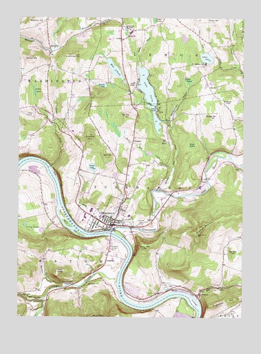
Tunkhannock, PA USGS Topographic Map
Click on map above to begin viewing in our Map Viewer.

This topographic map contains these locations and features:
Feature Name Type Latitude Longitude GNIS ID View Map
AldovinPopulated PlaceN41.6173°W75.9383°1168137View Map
Avery MountainSummitN41.5287°W75.9299°1168521View Map
Bartron PondLakeN41.5969°W75.9535°1168790View Map
Benson HollowValleyN41.5133°W75.9723°1169270View Map
Billings Mill BrookStreamN41.5529°W75.9213°1169625View Map
Borough of TunkhannockCivilN41.5412°W75.9487°1215735View Map
Bowman CreekStreamN41.5159°W75.9444°1198468View Map
BrooksidePopulated PlaceN41.5751°W75.9355°1203164View Map
C J K AirportAirportN41.5321°W75.8780°1194252View Map
Castle SchoolSchoolN41.5092°W75.9971°1171321View Map
Cedar LedgeSummitN41.5192°W75.9780°1192245View Map
Charles Brothers PlazaLocaleN41.5320°W75.9488°1214531View Map
Cooper CornersPopulated PlaceN41.5879°W75.9233°1172421View Map
Creamery PondLakeN41.6204°W75.9404°1172664View Map
Cruver PondLakeN41.5625°W75.9583°1172793View Map
DixonPopulated PlaceN41.5579°W75.8977°1173314View Map
DixonLocaleN41.5542°W75.9221°1202094View Map
Dixon CemeteryCemeteryN41.5626°W75.8896°1173316View Map
Eaton ChurchChurchN41.5237°W75.9502°1173936View Map
EatonvillePopulated PlaceN41.5145°W75.9610°1173939View Map
Eatonville SchoolSchoolN41.5142°W75.9685°1173940View Map
First IslandIslandN41.5351°W75.9660°1192462View Map
Fish Pond DamReservoirN41.6037°W75.9467°1195694View Map
Gallager SwampSwampN41.5378°W75.9907°1175388View Map
Garrison CreekStreamN41.6094°W75.9332°2761961View Map
German HillSummitN41.5273°W75.8805°1175552View Map
Helman SwampSwampN41.5987°W75.9059°1176797View Map
Horton CreekStreamN41.6045°W75.8771°1177475View Map
Jackson CemeteryCemeteryN41.5095°W75.9221°1177912View Map
Jackson CreekStreamN41.5109°W75.9130°1202093View Map
Jenkins SwampSwampN41.5943°W75.9910°1178034View Map
KaiservillePopulated PlaceN41.6117°W75.9821°1178209View Map
Kern GlenBasinN41.5631°W75.9169°1168008View Map
Kern Glen CreekStreamN41.5609°W75.9130°1178398View Map
Kintner HillSummitN41.5909°W75.9591°1178530View Map
La Grange IslandIslandN41.5065°W75.9013°1192727View Map
Lake CareyPopulated PlaceN41.5959°W75.9338°1178770View Map
Lake CareyLakeN41.5962°W75.9287°1171206View Map
Lake Carey DamDamN41.5817°W75.9196°1195680View Map
Lake Carey Post Office (historical)Post OfficeN41.5959°W75.9338°2027105View Map
Lake Carey Volunteer Fire CompanyBuildingN41.5951°W75.9355°2652734View Map
LemonLocaleN41.6112°W75.9430°1202096View Map
LemonPopulated PlaceN41.6162°W75.9424°1179189View Map
MarcyPopulated PlaceN41.5734°W75.9171°1204100View Map
Marcy ChurchChurchN41.5829°W75.9174°1180394View Map
Meade BrookStreamN41.6048°W75.9324°1180813View Map
Mill RunStreamN41.5076°W75.8999°1168013View Map
Mount AirySummitN41.5840°W75.9396°1168100View Map
Mud PondReservoirN41.5990°W75.9419°1182021View Map
Oak HillSummitN41.5676°W75.9502°1182764View Map
OsterhoutPopulated PlaceN41.5098°W75.8985°1183075View Map
Osterhout MountainSummitN41.5367°W75.8985°1183076View Map
Oxbow InletStreamN41.6106°W75.8966°1193074View Map
Oxbow LakeLakeN41.6084°W75.8954°1183165View Map
Prevost CemeteryCemeteryN41.5845°W75.9949°1184404View Map
Prospect HillSummitN41.5748°W75.9599°1184446View Map
Racavitch PondLakeN41.5896°W75.8847°1184569View Map
RosengrantPopulated PlaceN41.5065°W75.9855°1204547View Map
Roslund Elementary SchoolSchoolN41.5426°W75.9374°1207380View Map
Round SwampSwampN41.5720°W75.9030°1185537View Map
Route 6 PlazaLocaleN41.5417°W75.9621°1214530View Map
Saint Andrews CampLocaleN41.6054°W75.8958°1185754View Map
Second IslandIslandN41.5387°W75.9716°1193311View Map
Shadow Brook Golf CourseLocaleN41.5501°W75.9208°1205779View Map
Shupp HillSummitN41.5837°W75.8921°1187639View Map
Skyhaven AirportAirportN41.5293°W75.9460°1194250View Map
Stevens Lake DamDamN41.5984°W75.9430°1195693View Map
Sugar HollowValleyN41.5071°W75.9852°1188948View Map
Sugar Hollow CreekStreamN41.5073°W75.9852°1193493View Map
Sunnyside CemeteryCemeteryN41.5403°W75.9310°1189079View Map
Swale BrookStreamN41.5376°W75.9355°1189122View Map
Taques CreekStreamN41.5629°W75.9819°1189269View Map
Third IslandIslandN41.5423°W75.9746°1193529View Map
Towne PlazaLocaleN41.5434°W75.9605°1214529View Map
Township of EatonCivilN41.5011°W75.9814°1217264View Map
Township of LemonCivilN41.6137°W75.9135°1217268View Map
Township of TunkhannockCivilN41.5526°W75.9104°1217277View Map
Triton Hose CompanyBuildingN41.5411°W75.9550°2653116View Map
TunkhannockPopulated PlaceN41.5387°W75.9466°1213647View Map
Tunkhannock Community AmbulanceBuildingN41.5436°W75.9443°2722145View Map
Tunkhannock CreekStreamN41.5359°W75.9466°1189921View Map
Tunkhannock High SchoolSchoolN41.5451°W75.9588°1207378View Map
Tunkhannock Middle SchoolSchoolN41.5423°W75.9521°1207379View Map
Tunkhannock Post OfficePost OfficeN41.5393°W75.9466°2779688View Map
Tunkhannock Township Police DepartmentBuildingN41.5082°W75.9297°2780594View Map
Tyler Memorial HospitalHospitalN41.5776°W75.9697°2718016View Map
Valentine HillSummitN41.6092°W75.9680°1190280View Map
Vargo HillSummitN41.6242°W75.8916°1190367View Map
Village CenterLocaleN41.5312°W75.9477°1214532View Map
Whippoorwill HollowValleyN41.5784°W75.9150°1191233View Map
Yahmer HillSummitN41.6079°W75.9941°1191853View Map

Note: Coordinates in the location and feature list above are referenced to NAD83 datum.


Copyright (C) 2008-2024 Ryan Niemi / Sunset Dynamics ... All Rights Reserved