TopoQuest Logo
Do you find TopoQuest useful?
Help keep TopoQuest running and adding new maps/features by donating!
Bitcoin:  19c7KJd3qBynnjoSw5npx9KScwjBe4ifkT
Litecoin:  LXs6TkuXGGXo1vDsWCkWVdjQX94eUKd6ui
Home View Maps Find Maps Find Places Resources & Links


Unity Reservoir, Oregon Topographic Map

USGS Map Title: Unity Reservoir, OR
USGS Map MRC: 44118E2
DRG (GeoTIFF) Download: o44118e2.tif


Neighboring USGS Topographic Map Quads:


  Whitney, OR  
44118F3
 

  Sumpter, OR  
44118F2
 

  Phillips Lake, OR  
44118F1
 

  Pogue Point, OR  
44118E3
 

  Unity Reservoir, OR  
44118E2
 

  Beaverdam Creek, OR  
44118E1
 

  Rail Gulch, OR  
44118D3
 

  Unity, OR  
44118D2
 

  Hereford, OR  
44118D1


Map MRC Location:

N45°
W119°
N45°
W118°
H8 H7 H6 H5 H4 H3 H2 H1
G8 G7 G6 G5 G4 G3 G2 G1
F8 F7 F6 F5 F4 F3 F2 F1
E8 E7 E6 E5 E4 E3 E2 E1
D8 D7 D6 D5 D4 D3 D2 D1
C8 C7 C6 C5 C4 C3 C2 C1
B8 B7 B6 B5 B4 B3 B2 B1
A8 A7 A6 A5 A4 A3 A2 A1
N44°
W119°
N44°
W118°

Unity Reservoir, OR USGS 1:24K Topographic Map Preview:
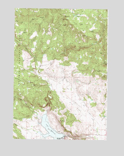
Unity Reservoir, OR USGS Topographic Map
Click on map above to begin viewing in our Map Viewer.

This topographic map contains these locations and features:
Feature Name Type Latitude Longitude GNIS ID View Map
Antelope CreekStreamN44.5499°W118.1891°1137236View Map
Audrey (historical)Populated PlaceN44.5688°W118.2191°1153982View Map
Audrey Post Office (historical)Post OfficeN44.5688°W118.2191°1164866View Map
Badger Hole SpringSpringN44.5667°W118.1372°1137399View Map
Barrel SpringSpringN44.5830°W118.1324°1137543View Map
Big FlatFlatN44.5321°W118.1688°1138027View Map
Big Flat CemeteryCemeteryN44.5429°W118.1635°1157007View Map
Big Flat DitchCanalN44.5382°W118.1749°1138029View Map
China CreekStreamN44.5702°W118.2172°1139670View Map
China Creek DitchCanalN44.5543°W118.1760°1139671View Map
China Creek SpringSpringN44.6104°W118.1591°1139672View Map
China LakeLakeN44.5875°W118.1467°1139687View Map
Cottonwood ButtesSummitN44.5721°W118.1263°1140168View Map
Cottonwood CreekStreamN44.5154°W118.1397°1140183View Map
Curran Mountain SpringSpringN44.6035°W118.1443°1140563View Map
Day SpringSpringN44.6200°W118.1686°1140676View Map
Derringer SpringSpringN44.6092°W118.1812°1140912View Map
Dooley GulchValleyN44.5510°W118.2027°1141190View Map
Dooley Gulch PondLakeN44.5517°W118.2245°1141191View Map
First CreekStreamN44.5785°W118.2224°1120744View Map
Fourth Creek Trail SpringSpringN44.6143°W118.2270°1142379View Map
Hanby ReservoirReservoirN44.5558°W118.1695°1153985View Map
Head MeadowFlatN44.5360°W118.1594°1638113View Map
Hereford DivisionCivilN44.5428°W118.1673°1938026View Map
King MountainSummitN44.5182°W118.1858°1144613View Map
King RanchLocaleN44.5699°W118.2160°1122754View Map
King SpringSpringN44.5659°W118.2340°1144616View Map
Lick CreekStreamN44.5902°W118.2408°1144981View Map
Lower First Creek SpringSpringN44.6149°W118.1858°1145621View Map
Martins MillLocaleN44.5949°W118.2255°1145854View Map
Max SpringSpringN44.5992°W118.1594°1145886View Map
Middle Fork Burnt RiverStreamN44.5071°W118.2169°1146138View Map
Mud SpringSpringN44.6179°W118.1681°1146600View Map
Mud Spring PondLakeN44.5742°W118.1307°1146609View Map
North Fork Burnt RiverStreamN44.5282°W118.2047°1146916View Map
Pine CreekStreamN44.5049°W118.1352°1147686View Map
Second CreekStreamN44.5882°W118.2355°1149203View Map
Second Creek SpringSpringN44.6160°W118.2111°1149207View Map
Sheep CreekStreamN44.5957°W118.2491°1149326View Map
Third CreekStreamN44.5927°W118.2435°1151060View Map
Third Creek SpringSpringN44.6017°W118.2383°1151063View Map
Thompson DitchCanalN44.5282°W118.2280°1153984View Map
Thompson GulchValleyN44.5360°W118.2385°1151108View Map
Unity DamDamN44.5043°W118.1803°1155670View Map
Unity Lake State Recreation Site Boat RampLocaleN44.5016°W118.1838°2700184View Map
Unity ReservoirReservoirN44.5068°W118.2000°1151661View Map
Upper First Creek SpringSpringN44.6176°W118.1836°1151677View Map
West Fork Burnt RiverStreamN44.5224°W118.2166°1152056View Map

Note: Coordinates in the location and feature list above are referenced to NAD83 datum.


Copyright (C) 2008-2025 Ryan Niemi / Sunset Dynamics ... All Rights Reserved