TopoQuest Logo
Do you find TopoQuest useful?
Help keep TopoQuest running and adding new maps/features by donating!
Bitcoin:  19c7KJd3qBynnjoSw5npx9KScwjBe4ifkT
Litecoin:  LXs6TkuXGGXo1vDsWCkWVdjQX94eUKd6ui
Home View Maps Find Maps Find Places Resources & Links


Valeene, Indiana Topographic Map

USGS Map Title: Valeene, IN
USGS Map MRC: 38086D4
DRG (GeoTIFF) Download: o38086d4.tif


Neighboring USGS Topographic Map Quads:


  French Lick, IN  
38086E5
 

  Paoli, IN  
38086E4
 

  Livonia, IN  
38086E3
 

  Greenbrier, IN  
38086D5
 

  Valeene, IN  
38086D4
 

  Hardinsburg, IN  
38086D3
 

  Taswell, IN  
38086C5
 

  English, IN  
38086C4
 

  Milltown, IN  
38086C3


Map MRC Location:

N39°
W87°
N39°
W86°
H8 H7 H6 H5 H4 H3 H2 H1
G8 G7 G6 G5 G4 G3 G2 G1
F8 F7 F6 F5 F4 F3 F2 F1
E8 E7 E6 E5 E4 E3 E2 E1
D8 D7 D6 D5 D4 D3 D2 D1
C8 C7 C6 C5 C4 C3 C2 C1
B8 B7 B6 B5 B4 B3 B2 B1
A8 A7 A6 A5 A4 A3 A2 A1
N38°
W87°
N38°
W86°

Valeene, IN USGS 1:24K Topographic Map Preview:
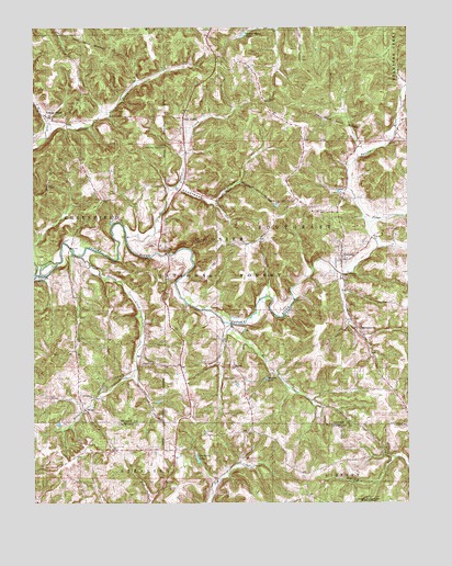
Valeene, IN USGS Topographic Map
Click on map above to begin viewing in our Map Viewer.

This topographic map contains these locations and features:
Feature Name Type Latitude Longitude GNIS ID View Map
Apple ChurchChurchN38.4587°W86.4953°450635View Map
BaconPopulated PlaceN38.4106°W86.4333°450640View Map
Bacon CreekStreamN38.4217°W86.4344°450641View Map
Bird HollowValleyN38.3762°W86.4610°450681View Map
Concord ChurchChurchN38.4806°W86.4219°450793View Map
Cooks ChapelChurchN38.4417°W86.4564°450797View Map
Danners CemeteryCemeteryN38.4898°W86.3783°450827View Map
Dillard CreekStreamN38.4401°W86.4842°450850View Map
FargoPopulated PlaceN38.4001°W86.4833°450905View Map
Fudge CreekStreamN38.4487°W86.3886°450945View Map
Gibbons FieldAirportN38.4487°W86.4444°2676868View Map
Hogs Defeat CreekStreamN38.4451°W86.4692°451053View Map
Inital Point Historical MonumentParkN38.4695°W86.4558°451087View Map
Little Africa CemeteryCemeteryN38.4937°W86.3939°452520View Map
Mill CreekStreamN38.4712°W86.4961°451218View Map
PearsontownPopulated PlaceN38.4209°W86.3916°451321View Map
Pine ValleyPopulated PlaceN38.4764°W86.4503°451336View Map
Providence ChurchChurchN38.4031°W86.4803°451368View Map
Purkhiser CemeteryCemeteryN38.3937°W86.4439°451373View Map
Sleepy Hollow LakeReservoirN38.4985°W86.4293°451472View Map
Southeast Orange County Volunteer Fire DepartmentBuildingN38.4516°W86.4070°2626485View Map
Timberlin LakeReservoirN38.3868°W86.4454°452523View Map
Township of SoutheastCivilN38.4438°W86.3849°453856View Map
Underwood HollowValleyN38.4581°W86.4505°451587View Map
ValeenePopulated PlaceN38.4389°W86.3972°451594View Map
Walton LakeReservoirN38.4075°W86.4226°451608View Map
Youngs CreekPopulated PlaceN38.4767°W86.4955°451651View Map

Note: Coordinates in the location and feature list above are referenced to NAD83 datum.


Copyright (C) 2008-2024 Ryan Niemi / Sunset Dynamics ... All Rights Reserved