TopoQuest Logo
Do you find TopoQuest useful?
Help keep TopoQuest running and adding new maps/features by donating!
Bitcoin:  19c7KJd3qBynnjoSw5npx9KScwjBe4ifkT
Litecoin:  LXs6TkuXGGXo1vDsWCkWVdjQX94eUKd6ui
Home View Maps Find Maps Find Places Resources & Links


Paoli, Indiana Topographic Map

USGS Map Title: Paoli, IN
USGS Map MRC: 38086E4
DRG (GeoTIFF) Download: o38086e4.tif


Neighboring USGS Topographic Map Quads:


  Georgia, IN  
38086F5
 

  Mitchell, IN  
38086F4
 

  Campbellsburg, IN  
38086F3
 

  French Lick, IN  
38086E5
 

  Paoli, IN  
38086E4
 

  Livonia, IN  
38086E3
 

  Greenbrier, IN  
38086D5
 

  Valeene, IN  
38086D4
 

  Hardinsburg, IN  
38086D3


Map MRC Location:

N39°
W87°
N39°
W86°
H8 H7 H6 H5 H4 H3 H2 H1
G8 G7 G6 G5 G4 G3 G2 G1
F8 F7 F6 F5 F4 F3 F2 F1
E8 E7 E6 E5 E4 E3 E2 E1
D8 D7 D6 D5 D4 D3 D2 D1
C8 C7 C6 C5 C4 C3 C2 C1
B8 B7 B6 B5 B4 B3 B2 B1
A8 A7 A6 A5 A4 A3 A2 A1
N38°
W87°
N38°
W86°

Paoli, IN USGS 1:24K Topographic Map Preview:
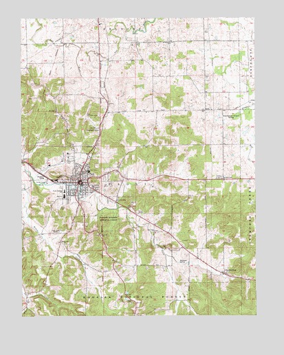
Paoli, IN USGS Topographic Map
Click on map above to begin viewing in our Map Viewer.

This topographic map contains these locations and features:
Feature Name Type Latitude Longitude GNIS ID View Map
Air Evacuation Lifeteam 17 Emergency Medical ServicesBuildingN38.5687°W86.4750°2719423View Map
Beech Grove ChurchChurchN38.5303°W86.4769°450670View Map
Braxtons SidingPopulated PlaceN38.5592°W86.4880°450705View Map
Calcar QuarryMineN38.5467°W86.4411°2635323View Map
ChambersburgPopulated PlaceN38.5181°W86.3922°450763View Map
Christ of King ChurchChurchN38.5484°W86.4494°450773View Map
Gravel RunStreamN38.5081°W86.4969°450979View Map
Halfmoon SpringsSpringN38.5223°W86.4158°450998View Map
Irvin CemeteryCemeteryN38.6189°W86.4016°451090View Map
IU Health Paoli HospitalHospitalN38.5683°W86.4751°2660495View Map
Lewis CemeteryCemeteryN38.6009°W86.4014°451853View Map
Lick Creek ChurchChurchN38.5356°W86.4289°451143View Map
Lost RiverPopulated PlaceN38.6070°W86.4514°451660View Map
Lost River Game FarmLocaleN38.6167°W86.4703°2635433View Map
Mount Gilead ChurchChurchN38.5859°W86.4811°451243View Map
Mount Pleasant ChurchChurchN38.6145°W86.4200°451252View Map
Newberry ChurchChurchN38.5651°W86.4994°451275View Map
Orange CountyCivilN38.5418°W86.4951°451681View Map
Orange County CourthouseBuildingN38.5561°W86.4683°2634524View Map
Orange County Sheriff's OfficeBuildingN38.5557°W86.4662°2758478View Map
PaoliPopulated PlaceN38.5562°W86.4683°451312View Map
Paoli Community CemeteryCemeteryN38.5492°W86.4755°451827View Map
Paoli Fire DepartmentBuildingN38.5566°W86.4807°2626476View Map
Paoli Junior and Senior High SchoolSchoolN38.5506°W86.4767°451736View Map
Paoli Municipal AirportAirportN38.5794°W86.4601°451815View Map
Paoli Police DepartmentBuildingN38.5561°W86.4778°2758243View Map
Pioneer Mothers Memorial ForestForestN38.5395°W86.4536°451339View Map
Pioneer Mothers State WaysideParkN38.5342°W86.4583°451852View Map
Scott CemeteryCemeteryN38.6142°W86.4383°451440View Map
Spring MillBuildingN38.5284°W86.4239°451497View Map
Stampers CreekStreamN38.5834°W86.3867°451505View Map
Stampers CreekPopulated PlaceN38.5584°W86.3833°451819View Map
Stampers Creek ChurchChurchN38.5573°W86.3930°451506View Map
Stampers Creek SinksBasinN38.5837°W86.3867°451507View Map
Stouts ChapelChurchN38.5067°W86.4414°451515View Map
SyriaPopulated PlaceN38.5862°W86.4017°451535View Map
Throop Elementary School Number 1SchoolN38.5523°W86.4769°451562View Map
Town of PaoliCivilN38.5572°W86.4699°2396846View Map
Township of PaoliCivilN38.5553°W86.4563°453705View Map
WKKX-AM (Paoli)TowerN38.5403°W86.4783°451793View Map
Wolf CreekStreamN38.5706°W86.3819°451643View Map
Woodlawn GrovePopulated PlaceN38.5781°W86.4580°449949View Map
WVAKTowerN38.5362°W86.4792°451828View Map
WVME-FM (Paoli)TowerN38.5403°W86.4783°451810View Map

Note: Coordinates in the location and feature list above are referenced to NAD83 datum.


Copyright (C) 2008-2025 Ryan Niemi / Sunset Dynamics ... All Rights Reserved