TopoQuest Logo
Do you find TopoQuest useful?
Help keep TopoQuest running and adding new maps/features by donating!
Bitcoin:  19c7KJd3qBynnjoSw5npx9KScwjBe4ifkT
Litecoin:  LXs6TkuXGGXo1vDsWCkWVdjQX94eUKd6ui
Home View Maps Find Maps Find Places Resources & Links


Volga, Indiana Topographic Map

USGS Map Title: Volga, IN
USGS Map MRC: 38085G5
DRG (GeoTIFF) Download: o38085g5.tif


Neighboring USGS Topographic Map Quads:


  Hayden, IN  
38085H6
 

  Vernon, IN  
38085H5
 

  San Jacinto, IN  
38085H4
 

  Deputy, IN  
38085G6
 

  Volga, IN  
38085G5
 

  Clifty Falls, IN  
38085G4
 

  Blocher, IN  
38085F6
 

  Kent, IN  
38085F5
 

  Madison West, IN  
38085F4


Map MRC Location:

N39°
W86°
N39°
W85°
H8 H7 H6 H5 H4 H3 H2 H1
G8 G7 G6 G5 G4 G3 G2 G1
F8 F7 F6 F5 F4 F3 F2 F1
E8 E7 E6 E5 E4 E3 E2 E1
D8 D7 D6 D5 D4 D3 D2 D1
C8 C7 C6 C5 C4 C3 C2 C1
B8 B7 B6 B5 B4 B3 B2 B1
A8 A7 A6 A5 A4 A3 A2 A1
N38°
W86°
N38°
W85°

Volga, IN USGS 1:24K Topographic Map Preview:
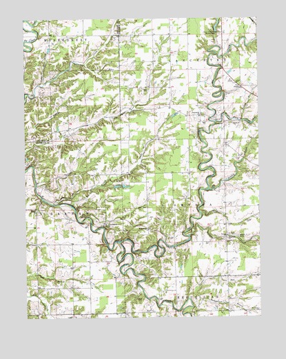
Volga, IN USGS Topographic Map
Click on map above to begin viewing in our Map Viewer.

This topographic map contains these locations and features:
Feature Name Type Latitude Longitude GNIS ID View Map
Camp Louis ErnstParkN38.8687°W85.5214°432044View Map
Chicken RunStreamN38.7578°W85.5389°432473View Map
Clashman CemeteryCemeteryN38.8275°W85.5326°432580View Map
College Hill CemeteryCemeteryN38.8316°W85.5139°432771View Map
Five PointsPopulated PlaceN38.8462°W85.5091°434542View Map
Ford CemeteryCemeteryN38.7814°W85.5271°434638View Map
Goose CreekStreamN38.7937°W85.5316°435192View Map
Graham Post Office (historical)Post OfficeN38.7917°W85.6086°453026View Map
Harberts CreekStreamN38.7839°W85.5383°435719View Map
Hensley CreekStreamN38.8034°W85.5283°436043View Map
Hopewell CemeteryCemeteryN38.7815°W85.5182°436448View Map
Hopewell ChurchChurchN38.7828°W85.5175°436454View Map
Kinnear CemeteryCemeteryN38.7901°W85.5072°437341View Map
LancasterPopulated PlaceN38.8314°W85.5186°437590View Map
Lancaster ChurchChurchN38.8348°W85.5314°437594View Map
Lawler CemeteryCemeteryN38.7831°W85.5487°437660View Map
Lick Branch ChurchChurchN38.7881°W85.5816°437852View Map
Little Bear CreekStreamN38.8473°W85.6175°437988View Map
Little CreekStreamN38.7812°W85.5752°438032View Map
Lloyd CemeteryCemeteryN38.7581°W85.5544°438192View Map
McKay CemeteryCemeteryN38.8165°W85.5101°438887View Map
Middle Fork CreekStreamN38.8314°W85.5233°439097View Map
Miller LakeReservoirN38.8699°W85.5223°448894View Map
Miller Lake DamDamN38.8684°W85.5233°448893View Map
Neavill CemeteryCemeteryN38.7848°W85.5136°439959View Map
Neavill GrovePopulated PlaceN38.7834°W85.5116°439960View Map
Neils Creek Post Office (historical)Post OfficeN38.8326°W85.5869°453025View Map
Nelson CemeteryCemeteryN38.8453°W85.5586°439993View Map
Ogden CemeteryCemeteryN38.8317°W85.5275°440516View Map
Paradise Acre LakeReservoirN38.8417°W85.5683°447209View Map
Pisgah ChurchChurchN38.7951°W85.6191°441194View Map
Scotland CemeteryCemeteryN38.7527°W85.5028°443135View Map
Shiloh CemeteryCemeteryN38.7889°W85.5171°443382View Map
Shingleton DamDamN38.8417°W85.5683°447273View Map
Thompson BranchStreamN38.7548°W85.5361°444698View Map
Township of LancasterCivilN38.8651°W85.5136°453539View Map
Township of SmyrnaCivilN38.7931°W85.5149°453855View Map
Turkey BranchStreamN38.8323°W85.5108°444957View Map
VolgaPopulated PlaceN38.7839°W85.5180°445316View Map
WakefieldPopulated PlaceN38.7873°W85.5600°445360View Map
Walton CreekStreamN38.7976°W85.6102°445455View Map

Note: Coordinates in the location and feature list above are referenced to NAD83 datum.


Copyright (C) 2008-2024 Ryan Niemi / Sunset Dynamics ... All Rights Reserved